
Lake Moogerah
Encyclopedia
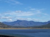
Lake Moogerah, formed by Moogerah Dam, is a water supply and irrigation dam on Reynolds Creek, a tributary of the Bremer River in Southeast Queensland
's Fassifern Valley
. The lake
is used for recreation, fishing and camping. "Moogerah" comes from the aboriginal word Moojirah meaning home of the thunderstorm.
The lake is located around 60 km southwest of Ipswich
and about 90 minutes drive from Brisbane
. Aratula
is the nearest town, about 11 km from the lake.
The dam supplies drinking water to the towns of Boonah
and Ipswich
, although the main user is the Swanbank Power Station
. It also supplies irrigation water to small crop farms in the Fassifern Valley. SunWater is undertaking a dam spillway
capacity upgrade program to ensure the continued safety of the dam.
in Moogerah Peaks National Park
.
During the 1995 drought dam levels declined to a low of 1% total capacity. The dam reached 100% capacity due to rainfall associated with the 2010–2011 Queensland floods
, with water flowing over the spillway for the first time since 1991 on 6 December 2010.
Pepperina Hill Campsite, which is primarily used for grade 8-10 camps.
As well as the barbecues and picnic areas available at Lake Moogerah Caravan Park there are a number of barbecues, covered picnic tables, toilet facilities and playgrounds on the opposite side of the lake at Haig Park. This side also provides access to the dam wall. Across the wall is Mount Edwards - a walking trail and hike. The road uphill behind the old kiosk (now a house) leads to a lookout and downhill to a further picnic area and playground at the bottom of the wall on the banks of Reynolds Creek.
operate a caravan park at the end of Muller Park road. It offers a variety of accommodation (powered, unpowered tent and caravan sites, overnight cabin and house and permanent cabins). Other site facilities include electric and wood barbecues, two boat ramps, kiosk (bread, milk, ice, firewood and sundries), kayak hire and children's playground. Lake Moogerah Caravan Park is located near many of the areas attractions and activities, including wineries, national parks and Lake Moogerah.
Queensland
Queensland is a state of Australia, occupying the north-eastern section of the mainland continent. It is bordered by the Northern Territory, South Australia and New South Wales to the west, south-west and south respectively. To the east, Queensland is bordered by the Coral Sea and Pacific Ocean...
's Fassifern Valley
Fassifern Valley
Fassifern Valley is a valley of the Scenic Rim in South East Queensland. Towns found in the valley include Harrisville, Kalbar, Roadvale, Warril View and Aratula...
. The lake
Lake
A lake is a body of relatively still fresh or salt water of considerable size, localized in a basin, that is surrounded by land. Lakes are inland and not part of the ocean and therefore are distinct from lagoons, and are larger and deeper than ponds. Lakes can be contrasted with rivers or streams,...
is used for recreation, fishing and camping. "Moogerah" comes from the aboriginal word Moojirah meaning home of the thunderstorm.
The lake is located around 60 km southwest of Ipswich
Ipswich, Queensland
Ipswich is a city in South-East Queensland, Australia. Situated along the Bremer River Valley approximately 40 kilometres away from the state's capital Brisbane. The suburb by the same name forms the city's Central Business District and administrative centre...
and about 90 minutes drive from Brisbane
Brisbane
Brisbane is the capital and most populous city in the Australian state of Queensland and the third most populous city in Australia. Brisbane's metropolitan area has a population of over 2 million, and the South East Queensland urban conurbation, centred around Brisbane, encompasses a population of...
. Aratula
Aratula, Queensland
Aratula is a small town in South East Queensland, approximately 60 kilometres southwest of Ipswich, just east of Cunninghams Gap. Warril Creek passes very close to the town...
is the nearest town, about 11 km from the lake.
The dam supplies drinking water to the towns of Boonah
Boonah, Queensland
Boonah is a town in south eastern Queensland, Australia. At the 2006 census, the town had a population of 2,285. The area produces vegetables for the nearby Brisbane Markets notably carrots, potatoes, and cereal crops. Beef, pork and timber are also produced locally.The town is positioned near the...
and Ipswich
Ipswich, Queensland
Ipswich is a city in South-East Queensland, Australia. Situated along the Bremer River Valley approximately 40 kilometres away from the state's capital Brisbane. The suburb by the same name forms the city's Central Business District and administrative centre...
, although the main user is the Swanbank Power Station
Swanbank Power Station, Queensland
Swanbank Power Station is located in Swanbank within South East Queensland, Australia. It is coal, natural gas, and landfill gas powered with a combined generation capacity of 865 MW of electricity....
. It also supplies irrigation water to small crop farms in the Fassifern Valley. SunWater is undertaking a dam spillway
Spillway
A spillway is a structure used to provide the controlled release of flows from a dam or levee into a downstream area, typically being the river that was dammed. In the UK they may be known as overflow channels. Spillways release floods so that the water does not overtop and damage or even destroy...
capacity upgrade program to ensure the continued safety of the dam.
History
Construction on the dam began in 1959, although land for the project was resumed as early as 1916. Moogerah Dam was completed in 1961 as the central catchment of the Warrill Valley Water Supply Scheme. The dam wall at Lake Moogerah allows access to Mount EdwardsMount Edwards
Mount Edwards is a mountain in South East Queensland, Australia. The mountain rises 634 m above sea level and is part of the Moogerah Peaks National Park. It lies approximately 100 km south west of Brisbane just outside the town of Boonah. The mountain is the closest of the Moogerah Peaks to...
in Moogerah Peaks National Park
Moogerah Peaks National Park
Moogerah Peaks is a National Park in the Fassifern Valley of South East Queensland, Australia, located approximately 70 km south west of the state capital Brisbane...
.
During the 1995 drought dam levels declined to a low of 1% total capacity. The dam reached 100% capacity due to rainfall associated with the 2010–2011 Queensland floods
2010–2011 Queensland floods
A series of floods hit Australia, beginning in December 2010, primarily in the state of Queensland including its capital city, Brisbane. The floods forced the evacuation of thousands of people from towns and cities. At least seventy towns and over 200,000 people were affected. Damage initially was...
, with water flowing over the spillway for the first time since 1991 on 6 December 2010.
Recreation
There is a caravan park at Moogerah Dam. Camp Moogerah is on the eastern shore of the lake, offering cabin accommodation and outdoor activity camps for schools, churches, youth groups, sports clubs etc.. On the western shore are Camp Mallon and Camp Laurence which offer group accommodation camps with educational and adventure activities for school students, family and church groups. On the southern shore is the privately owned and used, Brisbane Grammar SchoolBrisbane Grammar School
Brisbane Grammar School is an independent, non-denominational, day and boarding school for boys, located in Spring Hill, an inner suburb of Brisbane, Queensland, Australia...
Pepperina Hill Campsite, which is primarily used for grade 8-10 camps.
As well as the barbecues and picnic areas available at Lake Moogerah Caravan Park there are a number of barbecues, covered picnic tables, toilet facilities and playgrounds on the opposite side of the lake at Haig Park. This side also provides access to the dam wall. Across the wall is Mount Edwards - a walking trail and hike. The road uphill behind the old kiosk (now a house) leads to a lookout and downhill to a further picnic area and playground at the bottom of the wall on the banks of Reynolds Creek.
Camping
Scenic Rim Regional CouncilScenic Rim Regional Council
The Scenic Rim Region is a Local Government Area located in West Moreton region of South East Queensland, Australia. Established in 2008, it was preceded by several previous local government areas with histories extending back to the early 1900s and beyond....
operate a caravan park at the end of Muller Park road. It offers a variety of accommodation (powered, unpowered tent and caravan sites, overnight cabin and house and permanent cabins). Other site facilities include electric and wood barbecues, two boat ramps, kiosk (bread, milk, ice, firewood and sundries), kayak hire and children's playground. Lake Moogerah Caravan Park is located near many of the areas attractions and activities, including wineries, national parks and Lake Moogerah.