
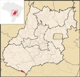
Lagoa Santa, Goiás
Encyclopedia
| Lagoa Santa | |
|---|---|
| State | Goiás Goiás Goiás is a state of Brazil, located in the central part of the country. The name Goiás comes from the name of an indigenous community... |
| Coordinates: | 19°10′55"S 51°23′01"W |
| Area: | 458.8 km² |
| Population: | 1,225 (IBGE 2007) |
| Elevation: | 456m above sea level |
| Postcode (CEP): | 75819-000 |
| Became a city: | 2001 |
| Mayor: | Álvaro Conrado Francisco (2005) |
| IBGE statistical Microregion: | Quirinópolis Microregion Quirinópolis Microregion The Quirinópolis Microregion is a region in south Goiás state, Brazil. It includes 8 municipalities with a population of 95,094 and a total area of 16,117.60 km². The population density was 5.89 km²... |
| Distance to Goiânia Goiânia -Climate:The city has a tropical wet and dry climate with an average temperature of . There's a wet season, from October to April, and a dry one, from May to September. Annual rainfall is around 1,520 mm.... : |
330 km. |
| Website: | none (March 2008) |
Municipality
A municipality is essentially an urban administrative division having corporate status and usually powers of self-government. It can also be used to mean the governing body of a municipality. A municipality is a general-purpose administrative subdivision, as opposed to a special-purpose district...
in southeast Goiás
Goiás
Goiás is a state of Brazil, located in the central part of the country. The name Goiás comes from the name of an indigenous community...
state, Brazil
Brazil
Brazil , officially the Federative Republic of Brazil , is the largest country in South America. It is the world's fifth largest country, both by geographical area and by population with over 192 million people...
. Lagoa Santa is one of the most recent municipalities in the state, having been installed on 1 January 2001. It has hot water springs and is being developed as a resort.
Location
Lagoa Santa is located on the border with the state of Mato Grosso do SulMato Grosso do Sul
Mato Grosso do Sul is one of the states of Brazil.Neighboring Brazilian states are Mato Grosso, Goiás, Minas Gerais, São Paulo and Paraná. It also borders the countries of Paraguay and Bolivia to the west. The economy of the state is largely based on agriculture and cattle-raising...
, divided by the Aporé River, a tributary of the Paraná
Paraná River
The Paraná River is a river in south Central South America, running through Brazil, Paraguay and Argentina for some . It is second in length only to the Amazon River among South American rivers. The name Paraná is an abbreviation of the phrase "para rehe onáva", which comes from the Tupi language...
. It is 483 kilometers from the state capital, Goiânia
Goiânia
-Climate:The city has a tropical wet and dry climate with an average temperature of . There's a wet season, from October to April, and a dry one, from May to September. Annual rainfall is around 1,520 mm....
and is connected by highways BR-153 and BR-060, leaving from São Paulo, and from Goiânia, by highways Br-060 and BR-164 and GO-206 and GO-302.
Connections with the state capital are made by BR-060 / Abadia de Goiás
Abadia de Goiás
Abadia de Goiás is a small town and municipality in central Goiás state, Brazil, located on the western edge of the Goiânia metropolitan area.-Geographical Data:The distance to Goiânia is 27 km...
/ Guapó
Guapó
Guapó is a small town and municipality in central Goiás state, Brazil. The population was 13,586 and the total area of the municipality was 517.0 km² .Guapó is part of the Goiânia Microregion...
/ Indiara
Indiara
Indiara is a small city and municipality in central-south Goiás state, Brazil. Indiara is a large producer of soybeans and cotton.-Location:Indiara is located in the Vale do Rio dos Bois and has municipal boundaries with:*north: Palmeiras de Goiás...
/ Acreúna
Acreúna
Acreúna is a small city and municipality in western Goiás state, Brazil.-Location:Acreúna is located in the statistical micro-region of Vale do Rio dos Bois, southwest of the state capital, Goiânia, on BR-060, which links Goiânia with Rio Verde...
/ Rio Verde
Rio Verde, Goiás
Rio Verde is a city and municipality in the Brazilian state of Goiás. It is a fast-growing center and is the largest producer of grains in the state.-Location:...
/ GO-174 / GO-422 / Caçu
Caçu
Caçu is a small town and municipality in southwest Goiás state, Brazil.-Location:Caçu is part of the Quirinópolis Microregion. It is located 330 kilometers from the state capital, Goiânia and is crossed by highway GO-206, which links the city with Quirinópolis...
/ GO-206 / Itarumã
Itarumã
Itarumã is a small town and municipality in south Goiás state, Brazil. , it has a population of 6,298. Itarumã is a large producer of cattle with a herd of almost three hundred thousand head.-Location:...
/ GO-178 / Itajá / GO-302.
It has boundaries on the north, east, and west with Itajá, and on the south with the state of Mato Grosso do Sul
Mato Grosso do Sul
Mato Grosso do Sul is one of the states of Brazil.Neighboring Brazilian states are Mato Grosso, Goiás, Minas Gerais, São Paulo and Paraná. It also borders the countries of Paraguay and Bolivia to the west. The economy of the state is largely based on agriculture and cattle-raising...
.
Geography
The average elevation is 380 meters and the average annual temperature is approximately 20°C to 24°C, with the minimum of 17°C and the maximum of 31°C. It is not uncommon to have cold fronts in the region, which come from the south. The climate is very humid, with humidity around 70%.The town is crossed by the Rio Aporé, on the border with Mato Grosso do Sul
Mato Grosso do Sul
Mato Grosso do Sul is one of the states of Brazil.Neighboring Brazilian states are Mato Grosso, Goiás, Minas Gerais, São Paulo and Paraná. It also borders the countries of Paraguay and Bolivia to the west. The economy of the state is largely based on agriculture and cattle-raising...
. In the tropical forest along the river there is a natural lake, Lagoa Santa, with water temperatures of around 31°C. This lake gave the town its name and is visited by tourists from all over the country, who seek a cure in the warm and medicinal waters of the lake.
Demographics
- Population density in 2007: 2.67 inhab/km²
- Total population in 2007: 5,409
- Urban population in 2007: 852
- Rural population in 2007: 373
The economy
The economy is based on services, government jobs, modest agriculture and cattle raising, and income generated from tourism. The cattle herd was 48,000 (2006).Economic Data (2007)
- Industrial establishments: 0
- Retail establishments in 2007: 22
- Automobiles: 60 (2007)
poo[
Main agricultural products in ha.(2006)
- rice: 100
- corn: 200
Farm Data (2006)in ha.
- Number of farms: 81
- Total area: 42,940
- Area of permanent crops: 33
- Area of perennial crops: 166
- Area of natural pasture: 31,372
- Persons dependent on farming: 212
- Farms with tractors: 37
- Number of tractors: 66 IBGE
Education and Health
There were 02 schools in activity (2006) and no hospitals.- Literacy Rate: n/a
- Infant mortality rate: n/a (in 1,000 live births)
Lagoa Santa was first created a district of Itajá in 1988 with the name Termas de Lagoa Santa. In 1998 it became a municipality with the present name.