
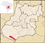
Itarumã
Encyclopedia
Itarumã is a small town
and municipality
in south Goiás
state, Brazil
. , it has a population of 6,298. Itarumã is a large producer of cattle with a herd of almost three hundred thousand head.
and is connected by paved roads with Caçu
, 40 kilometers to the north; and Itajá
, 45 kilometers to the south. It is 366 kilometers to the state capital, Goiânia
, which is connected by BR-060 / Abadia de Goiás
/ Guapó
/ Indiara
/ Acreúna
/ Rio Verde
/ GO-174 / GO-422 / Caçu
/ GO-206. See Sepin for all the distances.
Municipal boundaries are with:
Itarumã has one district: Olaria do Angico
Economic Data (2007)
Main agricultural products in ha.(2006)
Farm Data (2006)in ha.
Education and Health
There were 4 schools (2006) and 1 hospital with 13 beds (2007).
History
The documented history of European settlement of Itarumã begins in 1874 when Heitor Severino built the first house of palm fronds. The village was given the name of São Sebestião da Pimenta, honoring the saint and Dona Francisca Pimenta, a rich landowner of the region. The district was created in 1901, belonging to Jataí
, and on an unknown date the name was shortened to Pimenta. In 1943 the name was changed to Itarumã. In 1953 it was dismembered from Jataí and became a municipality.
Town
A town is a human settlement larger than a village but smaller than a city. The size a settlement must be in order to be called a "town" varies considerably in different parts of the world, so that, for example, many American "small towns" seem to British people to be no more than villages, while...
and municipality
Municipality
A municipality is essentially an urban administrative division having corporate status and usually powers of self-government. It can also be used to mean the governing body of a municipality. A municipality is a general-purpose administrative subdivision, as opposed to a special-purpose district...
in south Goiás
Goiás
Goiás is a state of Brazil, located in the central part of the country. The name Goiás comes from the name of an indigenous community...
state, Brazil
Brazil
Brazil , officially the Federative Republic of Brazil , is the largest country in South America. It is the world's fifth largest country, both by geographical area and by population with over 192 million people...
. , it has a population of 6,298. Itarumã is a large producer of cattle with a herd of almost three hundred thousand head.
Location
Itarumã is located in the Quirinópolis MicroregionQuirinópolis Microregion
The Quirinópolis Microregion is a region in south Goiás state, Brazil. It includes 8 municipalities with a population of 95,094 and a total area of 16,117.60 km². The population density was 5.89 km²...
and is connected by paved roads with Caçu
Caçu
Caçu is a small town and municipality in southwest Goiás state, Brazil.-Location:Caçu is part of the Quirinópolis Microregion. It is located 330 kilometers from the state capital, Goiânia and is crossed by highway GO-206, which links the city with Quirinópolis...
, 40 kilometers to the north; and Itajá
Itajá, Goiás
Itajá is a city in southwest Goiás state, Brazil. Itajá is a large producer of beef cattle.Itajá is part of the Quirinópolis Microregion. It is located eight kilometers north of the Aporá River, which forms the boundary between the states of Goiás and Mato Grosso do Sul.Itajá is 408 kilometers from...
, 45 kilometers to the south. It is 366 kilometers to the state capital, Goiânia
Goiânia
-Climate:The city has a tropical wet and dry climate with an average temperature of . There's a wet season, from October to April, and a dry one, from May to September. Annual rainfall is around 1,520 mm....
, which is connected by BR-060 / Abadia de Goiás
Abadia de Goiás
Abadia de Goiás is a small town and municipality in central Goiás state, Brazil, located on the western edge of the Goiânia metropolitan area.-Geographical Data:The distance to Goiânia is 27 km...
/ Guapó
Guapó
Guapó is a small town and municipality in central Goiás state, Brazil. The population was 13,586 and the total area of the municipality was 517.0 km² .Guapó is part of the Goiânia Microregion...
/ Indiara
Indiara
Indiara is a small city and municipality in central-south Goiás state, Brazil. Indiara is a large producer of soybeans and cotton.-Location:Indiara is located in the Vale do Rio dos Bois and has municipal boundaries with:*north: Palmeiras de Goiás...
/ Acreúna
Acreúna
Acreúna is a small city and municipality in western Goiás state, Brazil.-Location:Acreúna is located in the statistical micro-region of Vale do Rio dos Bois, southwest of the state capital, Goiânia, on BR-060, which links Goiânia with Rio Verde...
/ Rio Verde
Rio Verde, Goiás
Rio Verde is a city and municipality in the Brazilian state of Goiás. It is a fast-growing center and is the largest producer of grains in the state.-Location:...
/ GO-174 / GO-422 / Caçu
Caçu
Caçu is a small town and municipality in southwest Goiás state, Brazil.-Location:Caçu is part of the Quirinópolis Microregion. It is located 330 kilometers from the state capital, Goiânia and is crossed by highway GO-206, which links the city with Quirinópolis...
/ GO-206. See Sepin for all the distances.
Municipal boundaries are with:
- north: CaçuCaçuCaçu is a small town and municipality in southwest Goiás state, Brazil.-Location:Caçu is part of the Quirinópolis Microregion. It is located 330 kilometers from the state capital, Goiânia and is crossed by highway GO-206, which links the city with Quirinópolis...
, SerranópolisSerranópolisSerranópolis is a small town and municipality in southeast Goiás state, Brazil. It is one of the largest municipalities in the state in area and one of the most sparsely inhabited. It is a large producer of cattle and soybeans.-Location:...
, and JataíJataíJataí is a municipality in southern Goiás state, Brazil. Its population was 88,048 in a total area of 7,174.2 km². Jataí is a major producer of agricultural products, including soybeans, rice, and corn. It has the largest herd of cattle in the state and is a large producer of poultry and... - south: ItajáItajá, GoiásItajá is a city in southwest Goiás state, Brazil. Itajá is a large producer of beef cattle.Itajá is part of the Quirinópolis Microregion. It is located eight kilometers north of the Aporá River, which forms the boundary between the states of Goiás and Mato Grosso do Sul.Itajá is 408 kilometers from...
- east: Limeira do OesteLimeira do OesteLimeira do Oeste is a municipality in the west of the Brazilian state of Minas Gerais. As of 2007 the population was 6,492 in a total area of 1,318 km². It became a municipality in 1993.-Location:...
(Minas Gerais) - west: AporéAporéAporé is a small town and municipality in southwest Goiás state, Brazil. The municipality is a large producer of cattle. Aporé belongs to the Southwest Goiás Microregion.-Geography:...
and SerranópolisSerranópolisSerranópolis is a small town and municipality in southeast Goiás state, Brazil. It is one of the largest municipalities in the state in area and one of the most sparsely inhabited. It is a large producer of cattle and soybeans.-Location:...
Demographics
- Population density in 2007: 1.55 inhab/km²
- Population growth rate 1996/2007: 1.00.%
- Total population in 2007: 5,338
- Total population in 1980: 5,579
- Urban population in 2007: 3,479
- Rural population in 2007: 1,859
- Population change: the population has decreased by about 240 inhabitants since 1980.
Itarumã has one district: Olaria do Angico
The economy
The economy is based on cattle raising and cultivation of soybeans, rice, corn, sugarcane, and beans. The cattle herd is one of the largest in the state with 292,000 head.Economic Data (2007)
- Industrial establishments: 11
- Retail establishments in 2007: 62
- Dairies: Laticínios ABC Ind. e Comércio Ltda. Parmalat Brasil S/A - Indústria de Alimentos. (22/05/2006)
- Financial institutions: Banco do Brasil S.A. (August/2007)
- Automobiles: 373 (2007)
Main agricultural products in ha.(2006)
- rice: 400
- corn: 1,400
- soybeans: 1,500
Farm Data (2006)in ha.
- Number of farms: 411
- Total area: 254,132
- Area of permanent crops: 123
- Area of perennial crops: 263
- Area of natural pasture: 206,464
- Persons dependent on farming: 950
- Farms with tractors: 146
- Number of tractors: 211 IBGE
Education and Health
There were 4 schools (2006) and 1 hospital with 13 beds (2007).
- Literacy Rate: 85.3%
- Infant mortality rate: 28.88 (in 1,000 live births)
- Ranking on the Municipal Human Development IndexHuman Development IndexThe Human Development Index is a composite statistic used to rank countries by level of "human development" and separate "very high human development", "high human development", "medium human development", and "low human development" countries...
: 0.735 (medium) - State ranking: 126 (out of 242 municipalities in 2000)
- National ranking: 2,307 (out of 5,507 municipalities in 2000) For a complete list see Frigoletto.com
History
The documented history of European settlement of Itarumã begins in 1874 when Heitor Severino built the first house of palm fronds. The village was given the name of São Sebestião da Pimenta, honoring the saint and Dona Francisca Pimenta, a rich landowner of the region. The district was created in 1901, belonging to Jataí
Jataí
Jataí is a municipality in southern Goiás state, Brazil. Its population was 88,048 in a total area of 7,174.2 km². Jataí is a major producer of agricultural products, including soybeans, rice, and corn. It has the largest herd of cattle in the state and is a large producer of poultry and...
, and on an unknown date the name was shortened to Pimenta. In 1943 the name was changed to Itarumã. In 1953 it was dismembered from Jataí and became a municipality.