
Kratzerville, Pennsylvania
Encyclopedia
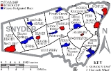
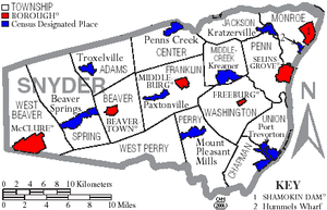
Kratzerville is a census-designated place
(CDP) in Snyder County
, Pennsylvania
, United States
. The population was 391 at the 2000 census.
According to the United States Census Bureau
, the CDP has a total area of 1 square miles (2.6 km²), all of it land.
of 2000, there were 391 people, 160 households, and 122 families residing in the CDP. The population density
was 398.6 people per square mile (154.0/km²). There were 167 housing units at an average density of 170.2/sq mi (65.8/km²). The racial makeup of the CDP was 98.98% White, 0.51% African American, 0.51% from other races
. Hispanic or Latino of any race were 0.51% of the population.
There were 160 households out of which 25.6% had children under the age of 18 living with them, 66.3% were married couples
living together, 7.5% had a female householder with no husband present, and 23.8% were non-families. 20.6% of all households were made up of individuals and 8.1% had someone living alone who was 65 years of age or older. The average household size was 2.44 and the average family size was 2.79.
In the CDP the population was spread out with 18.4% under the age of 18, 9.7% from 18 to 24, 29.4% from 25 to 44, 29.7% from 45 to 64, and 12.8% who were 65 years of age or older. The median age was 42 years. For every 100 females there were 92.6 males. For every 100 females age 18 and over, there were 91.0 males.
The median income for a household in the CDP was $42,292, and the median income for a family was $46,250. Males had a median income of $30,682 versus $22,321 for females. The per capita income
for the CDP was $20,008. About 1.6% of families and 3.1% of the population were below the poverty line, including none of those under age 18 and 10.2% of those age 65 or over.
Snyder County is governed by three elected county commissioners.
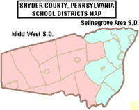 Selinsgrove Area School District
is the local public school system. There are approximately 2700 students clustered on a campus located in Selinsgrove borough. The Pennsylvania Department of Education projects a declining enrollment for the foreseeable future. In 2012, SASD enrollment is projected to be less than 2550.
In 2007, the district was ranked 325 out of 499 Pennsylvania school districts by Pittsburgh Business Times. The ranking is based on three years of Pennsylvania System of Student Assessment test scores.
SASD employes about 350 people in 2007. Two hundred of the employees are teachers. The median teacher salary in 2007 is $58,000 plus benefits. Seventy percent of spending is allocated to employee costs. The district reports spending $9800 per pupil in 2007. According to Hummel, costs for building projects coupled with salaries, transportation costs and increased charges for energy, will mean continued property tax increases.
Selinsgrove Area High School
has about 970 students in grades 9-12. There is a strong emphasis on music education and extracurricular athletics. In 2005 the high school was ranked 306th out of 601 Pennsylvania high schools on the annual state testing.
The Selinsgrove Area Middle School serves students in grades 6-8 using a team teaching approach. The school has been the district leader in providing rigorous instruction that prepares students to be successful on annual state assessments. The middle school ranked 179 out of 506 PA middle schools.
Selinsgrove Area Intermediate School
has students grades 3-5. Test scores for reading and math at this school have been lagging both regionally and statewide. The 3rd grade ranked 1215th out of 1779 Pennsylvania third grades.
Primary grades are at Selinsgrove Area Elementary School. Kindergarten is located at Jackson Penn School. In 2007, the district implemented All Day Kindergarten as a method of improving the low elementary math and reading scores. Selinsgrove Elementary will be renovated and enlarged to hold all kindergarten, first and second grades.
In 2005, Standard & Poors reported the district's student teacher ratio was 15.9 to 1.
Public school busing is provided.
Residents also have a wide selection of alternative schools. By law, the local public school must provide transportation to schools within 10 miles of the borders of the school district at no charge to the student.
The State Library of Pennsylvania Commonwealth & Walnut Sts., Harrisburg, PA. This library provides information for State Government and citizens, collects and preserves Pennsylvania's written heritage through materials published for, by, and about Pennsylvania.
Census-designated place
A census-designated place is a concentration of population identified by the United States Census Bureau for statistical purposes. CDPs are delineated for each decennial census as the statistical counterparts of incorporated places such as cities, towns and villages...
(CDP) in Snyder County
Snyder County, Pennsylvania
Snyder County is a county located in the U.S. state of Pennsylvania. As of 2010, the population was 39,702. Snyder County was formed in 1855 from parts of Union County...
, Pennsylvania
Pennsylvania
The Commonwealth of Pennsylvania is a U.S. state that is located in the Northeastern and Mid-Atlantic regions of the United States. The state borders Delaware and Maryland to the south, West Virginia to the southwest, Ohio to the west, New York and Ontario, Canada, to the north, and New Jersey to...
, United States
United States
The United States of America is a federal constitutional republic comprising fifty states and a federal district...
. The population was 391 at the 2000 census.
Geography
Kratzerville is located at 40°51′26"N 76°53′38"W (40.857229, -76.893989).According to the United States Census Bureau
United States Census Bureau
The United States Census Bureau is the government agency that is responsible for the United States Census. It also gathers other national demographic and economic data...
, the CDP has a total area of 1 square miles (2.6 km²), all of it land.
Demographics
As of the censusCensus
A census is the procedure of systematically acquiring and recording information about the members of a given population. It is a regularly occurring and official count of a particular population. The term is used mostly in connection with national population and housing censuses; other common...
of 2000, there were 391 people, 160 households, and 122 families residing in the CDP. The population density
Population density
Population density is a measurement of population per unit area or unit volume. It is frequently applied to living organisms, and particularly to humans...
was 398.6 people per square mile (154.0/km²). There were 167 housing units at an average density of 170.2/sq mi (65.8/km²). The racial makeup of the CDP was 98.98% White, 0.51% African American, 0.51% from other races
Race (United States Census)
Race and ethnicity in the United States Census, as defined by the Federal Office of Management and Budget and the United States Census Bureau, are self-identification data items in which residents choose the race or races with which they most closely identify, and indicate whether or not they are...
. Hispanic or Latino of any race were 0.51% of the population.
There were 160 households out of which 25.6% had children under the age of 18 living with them, 66.3% were married couples
Marriage
Marriage is a social union or legal contract between people that creates kinship. It is an institution in which interpersonal relationships, usually intimate and sexual, are acknowledged in a variety of ways, depending on the culture or subculture in which it is found...
living together, 7.5% had a female householder with no husband present, and 23.8% were non-families. 20.6% of all households were made up of individuals and 8.1% had someone living alone who was 65 years of age or older. The average household size was 2.44 and the average family size was 2.79.
In the CDP the population was spread out with 18.4% under the age of 18, 9.7% from 18 to 24, 29.4% from 25 to 44, 29.7% from 45 to 64, and 12.8% who were 65 years of age or older. The median age was 42 years. For every 100 females there were 92.6 males. For every 100 females age 18 and over, there were 91.0 males.
The median income for a household in the CDP was $42,292, and the median income for a family was $46,250. Males had a median income of $30,682 versus $22,321 for females. The per capita income
Per capita income
Per capita income or income per person is a measure of mean income within an economic aggregate, such as a country or city. It is calculated by taking a measure of all sources of income in the aggregate and dividing it by the total population...
for the CDP was $20,008. About 1.6% of families and 3.1% of the population were below the poverty line, including none of those under age 18 and 10.2% of those age 65 or over.
Government
Snyder County Government directorySnyder County is governed by three elected county commissioners.
Schools
Selinsgrove Area School District
Selinsgrove Area School District is a school district centered in Selinsgrove, Pennsylvania. Enrollment has declined to approximately 2700 students clustered on a campus located in Selinsgrove borough. The Pennsylvania Department of Education projects a continued decline in enrollment to 2500 in 2010...
is the local public school system. There are approximately 2700 students clustered on a campus located in Selinsgrove borough. The Pennsylvania Department of Education projects a declining enrollment for the foreseeable future. In 2012, SASD enrollment is projected to be less than 2550.
In 2007, the district was ranked 325 out of 499 Pennsylvania school districts by Pittsburgh Business Times. The ranking is based on three years of Pennsylvania System of Student Assessment test scores.
SASD employes about 350 people in 2007. Two hundred of the employees are teachers. The median teacher salary in 2007 is $58,000 plus benefits. Seventy percent of spending is allocated to employee costs. The district reports spending $9800 per pupil in 2007. According to Hummel, costs for building projects coupled with salaries, transportation costs and increased charges for energy, will mean continued property tax increases.
Selinsgrove Area High School
Selinsgrove Area High School
Selinsgrove Area High School is a public school located in Selinsgrove, Snyder County, Pennsylvania. It is a part of the Selinsgrove Area School District. The school's enrollment has declined to less than 850 students in grades nine through twelve. Further decline in enrollment is anticipated...
has about 970 students in grades 9-12. There is a strong emphasis on music education and extracurricular athletics. In 2005 the high school was ranked 306th out of 601 Pennsylvania high schools on the annual state testing.
The Selinsgrove Area Middle School serves students in grades 6-8 using a team teaching approach. The school has been the district leader in providing rigorous instruction that prepares students to be successful on annual state assessments. The middle school ranked 179 out of 506 PA middle schools.
Selinsgrove Area Intermediate School
Selinsgrove Area Intermediate School
Selinsgrove Area Intermediate School is a midsized, suburban public school located in Selinsgrove, Snyder County, Pennsylvania. It is a part of the Selinsgrove Area School District. In June 2011, the school board voted to realign the schools to make more effective use of school space and to...
has students grades 3-5. Test scores for reading and math at this school have been lagging both regionally and statewide. The 3rd grade ranked 1215th out of 1779 Pennsylvania third grades.
Primary grades are at Selinsgrove Area Elementary School. Kindergarten is located at Jackson Penn School. In 2007, the district implemented All Day Kindergarten as a method of improving the low elementary math and reading scores. Selinsgrove Elementary will be renovated and enlarged to hold all kindergarten, first and second grades.
In 2005, Standard & Poors reported the district's student teacher ratio was 15.9 to 1.
Public school busing is provided.
Residents also have a wide selection of alternative schools. By law, the local public school must provide transportation to schools within 10 miles of the borders of the school district at no charge to the student.
Libraries
The Selinsgrove Community Library is a public library that is part of the Snyder County Library system. Patrons have free use of the PA Power Library and Access Pennsylvania which provide extensive onlline resources for children and adults. The library is on the corner of High Street and Pine Street, one block west of Market Street in downtown Selinsgrove. A small book exchange cart is hosted in the U.S. Post Office building on Rte 11&15, Shamokin Dam.The State Library of Pennsylvania Commonwealth & Walnut Sts., Harrisburg, PA. This library provides information for State Government and citizens, collects and preserves Pennsylvania's written heritage through materials published for, by, and about Pennsylvania.