

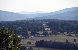
Knob Lick, Missouri
Encyclopedia
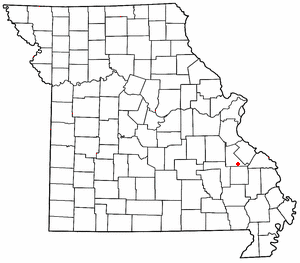
Saint Francois County, Missouri
St. Francois County is a county located in the Lead Belt region in Missouri in the United States. As of the 2000 U.S. Census, the county's population was 55,641. The 2010 Census, showed the population to be 65,359. The largest city and county seat is Farmington. The county was officially organized...
. It is located on U.S. Route 67
U.S. Route 67
U.S. Route 67 is a 1,560 mile long north–south U.S. highway in the Central United States. The southern terminus of the route is at the United States-Mexico border in Presidio, Texas, where it continues south as Mexican Federal Highway 16 upon crossing the Rio Grande. The northern...
about eight miles south of Farmington
Farmington, Missouri
Farmington is a city in St. Francois County located south of St. Louis in the Lead Belt region in Missouri in the United States. As of the 2010 U.S. Census, the population was 16,240. It is the county seat of St. Francois County. The Farmington Micropolitan Statistical Area embraces St...
. Knob Lick has a post office
United States Postal Service
The United States Postal Service is an independent agency of the United States government responsible for providing postal service in the United States...
with zip code
ZIP Code
ZIP codes are a system of postal codes used by the United States Postal Service since 1963. The term ZIP, an acronym for Zone Improvement Plan, is properly written in capital letters and was chosen to suggest that the mail travels more efficiently, and therefore more quickly, when senders use the...
63651.
The community was named in 1876 for the nearby Knob Lick Mountain. In the Ozarks, knob typically refers to an isolated summit, and lick is a natural "salt lick
Salt lick
A mineral lick is a natural mineral deposit where animals in nutrient-poor ecosystems can obtain essential mineral nutrients...
" or salt
Salt
In chemistry, salts are ionic compounds that result from the neutralization reaction of an acid and a base. They are composed of cations and anions so that the product is electrically neutral...
spring. The mountain is across U.S. Route 67
U.S. Route 67
U.S. Route 67 is a 1,560 mile long north–south U.S. highway in the Central United States. The southern terminus of the route is at the United States-Mexico border in Presidio, Texas, where it continues south as Mexican Federal Highway 16 upon crossing the Rio Grande. The northern...
from the town at 37.6645°N 90.3859°W. Eighty 80 acres (32.4 ha) of the summit are protected by the Missouri Department of Conservation
Missouri Department of Conservation
The Missouri Department of Conservation and the Missouri Conservation Commission were created by Article IV Sections 40-42 of the Missouri Constitution, which were adopted by the voters of the state in 1936 as Amendment 4 to the constitution...
. A gravel
Gravel
Gravel is composed of unconsolidated rock fragments that have a general particle size range and include size classes from granule- to boulder-sized fragments. Gravel can be sub-categorized into granule and cobble...
road leads to the conservation area
Conservation area
A conservation areas is a tract of land that has been awarded protected status in order to ensure that natural features, cultural heritage or biota are safeguarded...
which includes a granite
Granite
Granite is a common and widely occurring type of intrusive, felsic, igneous rock. Granite usually has a medium- to coarse-grained texture. Occasionally some individual crystals are larger than the groundmass, in which case the texture is known as porphyritic. A granitic rock with a porphyritic...
glade
Glade (geography)
A glade or clearing is an open area within a woodland. Glades are often grassy meadows under the canopy of deciduous trees such as red alder or quaking aspen in western North America. They also represent openings in forests where local conditions such as avalanches, poor soils, or fire damage have...
, picnic facilities, and a closed fire lookout tower
Fire lookout tower
A fire lookout tower, fire tower or lookout tower, provides housing and protection for a person known as a "fire lookout" whose duty it is to search for wildfires in the wilderness...
.
The St Louis and Iron Mountain Railroad
St. Louis, Iron Mountain and Southern Railway
The St. Louis, Iron Mountain and Southern Railway was a historic railroad that operated in Missouri, and Arkansas during the late 19th and early 20th centuries....
had a stop at Knob Lick that was a shipping point for granite mines in the area. There were also lead mines nearby, including Mine La Motte
Mine La Motte, Missouri
Mine La Motte is an unincorporated community in Madison County, Missouri, United States. It is located about six miles north of Fredericktown. Europeans discovered lead here, and Antoine de la Mothe Cadillac brought several hundred workers, including slaves from Santo Domingo, to develop mines in...
. Knob Lick has been home to the S-F Scout Ranch since 1965.