
Kingston Range
Encyclopedia
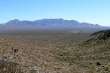
The Kingston Range, sometimes called the Kingston Mountains, is located in Inyo and San Bernardino counties in the Mojave Desert
in eastern California
. The range reaches a height of 7323 feet (2,232.1 m) above sea level at Kingston Peak.
The range is located southeast of the Nopah Range
, and north of the Shadow Mountains
and Interstate 15
. The small community of Halloran Springs
is about 22 miles (35.4 km) south of the Kingston Range. The range stretches about 18 mi (29 km) in a northeast-southwest direction. Tecopa Pass, at 5100 ft (1,554.5 m), is located at the northeastern end of the mountains.
Mojave Desert
The Mojave Desert occupies a significant portion of southeastern California and smaller parts of central California, southern Nevada, southwestern Utah and northwestern Arizona, in the United States...
in eastern California
California
California is a state located on the West Coast of the United States. It is by far the most populous U.S. state, and the third-largest by land area...
. The range reaches a height of 7323 feet (2,232.1 m) above sea level at Kingston Peak.
The range is located southeast of the Nopah Range
Nopah Range
The Nopah Range is located in Inyo County, California, USA, near the eastern border with Nevada.-Geography:The mountain range lies east of the adjacent Resting Spring Range, the Owlshead Mountains and lower Death Valley, and are north of the Kingston Range. The Amargosa River is to the west...
, and north of the Shadow Mountains
Shadow Mountains
The Shadow Mountains are located in the Mojave Desert of eastern California in the United States. The mountains lie in a generally north-south direction south of the Kingston Range and east of the Avawatz Mountains and the Silurian Hills....
and Interstate 15
Interstate 15 in California
In the U.S. state of California, Interstate 15 is a major north–south route through the San Bernardino, Riverside, and San Diego Counties, and it has a length of in the state. It is a major thoroughfare for traffic between Southern California and Las Vegas, Nevada, as well as points beyond...
. The small community of Halloran Springs
Halloran Springs, California
Halloran Springs is an unincorporated community in San Bernardino County, California, USA. It lies at in the Mojave Desert approximately 15 miles northeast of Baker, California on Interstate 15 between Baker and Las Vegas, Nevada....
is about 22 miles (35.4 km) south of the Kingston Range. The range stretches about 18 mi (29 km) in a northeast-southwest direction. Tecopa Pass, at 5100 ft (1,554.5 m), is located at the northeastern end of the mountains.