
King William Island
Encyclopedia
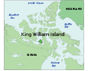
King William Island is an island in the Kitikmeot Region
of Nunavut
and forms part of the Canadian Arctic Archipelago
. In area it is between 12516 km² (4,832.5 sq mi) and 13111 km² (5,062.2 sq mi) making it the 61st largest island in the world and Canada's 15th largest island. Its population, as of the 2006 census
, was 1,064, all of which live in the island's only community Gjoa Haven
.
The island is separated from the Boothia Peninsula
by the James Ross Strait
to the northeast, and the Rae Strait
to the east. To the west is the Victoria Strait
and beyond it Victoria Island. Within the Simpson Strait
, to the south of the island, is Todd Island, and beyond it, further to the south, is the Adelaide Peninsula
. Queen Maud Gulf
lies to the southwest.
Victory Point is on its north coast. Gore Point, Point Le Vesconte, Erebus Bay and Terror Bay are on the west coast. Douglas Bay, Booth Point, and Gjoa Haven are on the south coast.
The island is known for its large populations of caribou
who summer there, before walking south over the sea ice
in the autumn.
, a number of polar explorers
visited, or spent their winters on, King William Island.
people, was originally named 'King William Land' for the reigning British
King William IV
in 1830 by the Arctic explorer John Ross
, who thought it was a peninsula.
's 1845 expedition became stranded in the sea ice northwest of the island. After the ships were abandoned, most of the crew gradually perished from exposure and starvation as they attempted to walk south near the western coastline. Two of Franklin's men are buried at Hall Point on the island's south coast.
, looking for the Northwest Passage, sailed through the James Ross Strait and stopped at a natural harbour on the island's south coast. There, unable to proceed due to sea ice, he spent the winters of 1903-4 and 1904-5. During his stays there he learned Arctic
living skills from the local Netsilik Inuit
that were later to be invaluable in his expedition to the South Pole
. He used his ship Gjøa
as a base for explorations in the summer of 1904, sledding the Boothia Peninsula and travelling to the North Magnetic Pole
. Amundsen finally left, after 22 months on the island, in August 1905. The harbour where he lived is now the island's only settlement, Gjoa Haven.
Kitikmeot Region, Nunavut
Kitikmeot Region is an administrative region of Nunavut, Canada. It consists of the southern and eastern parts of Victoria Island with the adjacent part of the mainland as far as the Boothia Peninsula, together with King William Island and the southern portion of Prince of Wales Island...
of Nunavut
Nunavut
Nunavut is the largest and newest federal territory of Canada; it was separated officially from the Northwest Territories on April 1, 1999, via the Nunavut Act and the Nunavut Land Claims Agreement Act, though the actual boundaries had been established in 1993...
and forms part of the Canadian Arctic Archipelago
Canadian Arctic Archipelago
The Canadian Arctic Archipelago, also known as the Arctic Archipelago, is a Canadian archipelago north of the Canadian mainland in the Arctic...
. In area it is between 12516 km² (4,832.5 sq mi) and 13111 km² (5,062.2 sq mi) making it the 61st largest island in the world and Canada's 15th largest island. Its population, as of the 2006 census
Canada 2006 Census
The Canada 2006 Census was a detailed enumeration of the Canadian population. Census day was May 16, 2006. The next census following will be the 2011 Census. Canada's total population enumerated by the 2006 census was 31,612,897...
, was 1,064, all of which live in the island's only community Gjoa Haven
Gjoa Haven, Nunavut
Gjoa Haven is a hamlet in Nunavut, above the Arctic Circle, located in the Kitikmeot Region, northeast of Yellowknife, Northwest Territories. It is the only settlement on King William Island...
.
The island is separated from the Boothia Peninsula
Boothia Peninsula
Boothia Peninsula is a large peninsula in Nunavut's northern Canadian Arctic, south of Somerset Island. The northern part, Murchison Promontory, is the northernmost point of mainland Canada, and thus North America....
by the James Ross Strait
James Ross Strait
James Ross Strait, an arm of the Arctic Ocean, is a channel between King William Island and the Boothia Peninsula in the Canadian province of Nunavut. long, and to wide, it connects M'Clintock Channel to the Rae Strait to the south...
to the northeast, and the Rae Strait
Rae Strait
Rae Strait, named after Arctic explorer John Rae, is a small strait in the Kitikmeot Region of Nunavut, Canada. It is located between King William Island and the Boothia Peninsula on the mainland to the east.-Source:* at the Atlas of Canada...
to the east. To the west is the Victoria Strait
Victoria Strait
Victoria Strait is a strait in northern Canada that lies in Nunavut off the mainland in the Arctic Ocean. It is between Victoria Island to the west and King William Island to the east. From the north the strait links the M'Clintock Channel and the Larsen Sound with the Queen Maud Gulf to the south...
and beyond it Victoria Island. Within the Simpson Strait
Simpson Strait
The Simpson Strait is a natural, shallow waterway separating King William Island to the north from Adelaide Peninsula on Nunavut's mainland to the south...
, to the south of the island, is Todd Island, and beyond it, further to the south, is the Adelaide Peninsula
Adelaide Peninsula
Adelaide Peninsula , ancestral home to the Illuilirmiut Inuit, is a large peninsula in Nunavut, Canada. It is located at south of King William Island....
. Queen Maud Gulf
Queen Maud Gulf
Queen Maud Gulf lies between the northern coast of the mainland and the southeastern corner of Victoria Island in Nunavut, Canada. At its western end lies Cambridge Bay, leading to Dease Strait; to the east lies Simpson Strait; and to the north, Victoria Strait.It was named by the Norwegian...
lies to the southwest.
Victory Point is on its north coast. Gore Point, Point Le Vesconte, Erebus Bay and Terror Bay are on the west coast. Douglas Bay, Booth Point, and Gjoa Haven are on the south coast.
The island is known for its large populations of caribou
Barren-ground Caribou
Barren-ground Caribou is a subspecies of the caribou that is found mainly in the Canadian territories Nunavut and the Northwest Territories and western Greenland. It sometimes includes the similar porcupine caribou, in which case the barren-ground caribou also is found in Alaska...
who summer there, before walking south over the sea ice
Sea ice
Sea ice is largely formed from seawater that freezes. Because the oceans consist of saltwater, this occurs below the freezing point of pure water, at about -1.8 °C ....
in the autumn.
Role in Arctic exploration
While searching for the Northwest PassageNorthwest Passage
The Northwest Passage is a sea route through the Arctic Ocean, along the northern coast of North America via waterways amidst the Canadian Arctic Archipelago, connecting the Atlantic and Pacific Oceans...
, a number of polar explorers
Arctic exploration
Arctic exploration is the physical exploration of the Arctic region of the Earth. The region that surrounds the North Pole. It refers to the historical period during which mankind has explored the region north of the Arctic Circle...
visited, or spent their winters on, King William Island.
John Ross
The island, long occupied by InuitInuit
The Inuit are a group of culturally similar indigenous peoples inhabiting the Arctic regions of Canada , Denmark , Russia and the United States . Inuit means “the people” in the Inuktitut language...
people, was originally named 'King William Land' for the reigning British
United Kingdom of Great Britain and Ireland
The United Kingdom of Great Britain and Ireland was the formal name of the United Kingdom during the period when what is now the Republic of Ireland formed a part of it....
King William IV
William IV of the United Kingdom
William IV was King of the United Kingdom of Great Britain and Ireland and of Hanover from 26 June 1830 until his death...
in 1830 by the Arctic explorer John Ross
John Ross (Arctic explorer)
Sir John Ross, CB, was a Scottish rear admiral and Arctic explorer.Ross was the son of the Rev. Andrew Ross, minister of Inch, near Stranraer in Scotland. In 1786, aged only nine, he joined the Royal Navy as an apprentice. He served in the Mediterranean until 1789 and then in the English Channel...
, who thought it was a peninsula.
John Franklin
John FranklinJohn Franklin
Rear-Admiral Sir John Franklin KCH FRGS RN was a British Royal Navy officer and Arctic explorer. Franklin also served as governor of Tasmania for several years. In his last expedition, he disappeared while attempting to chart and navigate a section of the Northwest Passage in the Canadian Arctic...
's 1845 expedition became stranded in the sea ice northwest of the island. After the ships were abandoned, most of the crew gradually perished from exposure and starvation as they attempted to walk south near the western coastline. Two of Franklin's men are buried at Hall Point on the island's south coast.
Roald Amundsen
In 1903, explorer Roald AmundsenRoald Amundsen
Roald Engelbregt Gravning Amundsen was a Norwegian explorer of polar regions. He led the first Antarctic expedition to reach the South Pole between 1910 and 1912 and he was the first person to reach both the North and South Poles. He is also known as the first to traverse the Northwest Passage....
, looking for the Northwest Passage, sailed through the James Ross Strait and stopped at a natural harbour on the island's south coast. There, unable to proceed due to sea ice, he spent the winters of 1903-4 and 1904-5. During his stays there he learned Arctic
Arctic
The Arctic is a region located at the northern-most part of the Earth. The Arctic consists of the Arctic Ocean and parts of Canada, Russia, Greenland, the United States, Norway, Sweden, Finland, and Iceland. The Arctic region consists of a vast, ice-covered ocean, surrounded by treeless permafrost...
living skills from the local Netsilik Inuit
Netsilik Inuit
The Netsilik Inuit live predominantly in the communities of Kugaaruk and Gjoa Haven of the Kitikmeot Region, Nunavut and to a smaller extent in Taloyoak and the north Qikiqtaaluk Region...
that were later to be invaluable in his expedition to the South Pole
South Pole
The South Pole, also known as the Geographic South Pole or Terrestrial South Pole, is one of the two points where the Earth's axis of rotation intersects its surface. It is the southernmost point on the surface of the Earth and lies on the opposite side of the Earth from the North Pole...
. He used his ship Gjøa
Gjøa
Gjøa was the first vessel to transit the Northwest Passage. With a crew of six, Roald Amundsen traversed the passage in a three year journey, finishing in 1906.- History :- Construction :...
as a base for explorations in the summer of 1904, sledding the Boothia Peninsula and travelling to the North Magnetic Pole
North Magnetic Pole
The Earth's North Magnetic Pole is the point on the surface of the Northern Hemisphere at which the Earth's magnetic field points vertically downwards . Though geographically in the north, it is, by the direction of the magnetic field lines, physically the south pole of the Earth's magnetic field...
. Amundsen finally left, after 22 months on the island, in August 1905. The harbour where he lived is now the island's only settlement, Gjoa Haven.