

King Street, Alexandria, Virginia
Encyclopedia
Alexandria, Virginia
Alexandria is an independent city in the Commonwealth of Virginia. As of 2009, the city had a total population of 139,966. Located along the Western bank of the Potomac River, Alexandria is approximately six miles south of downtown Washington, D.C.Like the rest of northern Virginia, as well as...
, USA and historic Old Town Alexandria. It extends westward from the Potomac River
Potomac River
The Potomac River flows into the Chesapeake Bay, located along the mid-Atlantic coast of the United States. The river is approximately long, with a drainage area of about 14,700 square miles...
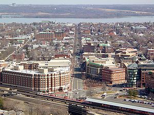
waterfront near the Torpedo Factory Art Center and nearby bustling tourist gift shops and restaurants, passing City Hall. On reaching the Washington Metro
Washington Metro
The Washington Metro, commonly called Metro, and unofficially Metrorail, is the rapid transit system in Washington, D.C., United States, and its surrounding suburbs. It is administered by the Washington Metropolitan Area Transit Authority , which also operates Metrobus service under the Metro name...
and Amtrak
Amtrak
The National Railroad Passenger Corporation, doing business as Amtrak , is a government-owned corporation that was organized on May 1, 1971, to provide intercity passenger train service in the United States. "Amtrak" is a portmanteau of the words "America" and "track". It is headquartered at Union...
stations and the George Washington National Masonic Memorial, King Street bends and narrows to just two lanes as it passes T.C. Williams High School and several historic churches, becoming Leesburg Pike as it passes out of Alexandria near the Bailey's Crossroads area. King Street becomes State Route 7 west of Washington Street (State Route 400). In Old Town Alexandria, King Street is designated as the dividing line between north and south in the addressing system
Address (geography)
An address is a collection of information, presented in a mostly fixed format, used for describing the location of a building, apartment, or other structure or a plot of land, generally using political boundaries and street names as references, along with other identifiers such as house or...
, while Duke Street (State Route 236) is designated as the dividing line in the West End area of Alexandria.
The line of King Street follows the original southwest border for the District of Columbia, becoming the Leesburg Pike as it extends westward into Fairfax County. The border is close to the edge of King Street between Seminary Road and just before George Mason Drive. Route 7 then follows in close proximity the continuation of the original District border that now forms the southern edge of Arlington County, Virginia
Arlington County, Virginia
Arlington County is a county in the Commonwealth of Virginia. The land that became Arlington was originally donated by Virginia to the United States government to form part of the new federal capital district. On February 27, 1801, the United States Congress organized the area as a subdivision of...
, until Seven Corners, where it enters the City of Falls Church, Virginia.
The Washington Metro
Washington Metro
The Washington Metro, commonly called Metro, and unofficially Metrorail, is the rapid transit system in Washington, D.C., United States, and its surrounding suburbs. It is administered by the Washington Metropolitan Area Transit Authority , which also operates Metrobus service under the Metro name...
has a station at King Street, just west of Old Town, on the Blue
Blue Line (Washington Metro)
The Blue Line of the Washington Metro in the United States consists of 27 rapid transit stations from Franconia–Springfield to Largo Town Center. It has stations in Fairfax County, Alexandria and Arlington, Virginia, the District of Columbia, and Prince George's County, Maryland...
and Yellow Lines
Yellow Line (Washington Metro)
The Yellow Line of the Washington Metro consists of 17 rapid transit stations from Huntington to Fort Totten. The line terminates at the Mount Vernon Square station during peak hours.Peak hours are 5 a.m. to 9:30 a.m. and 3 p.m. to 7 p.m. Service is extended to the Green Line stations during...
. Also, the King Street Trolley often takes tourists on a ride along King Street.