
Khibiny Massif
Encyclopedia
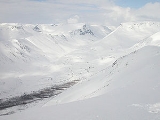
The Khibiny Massif, Khibiny Mountains, Khibinsky Mountains or Khibins, Khibinsky tundras, Khibiny ( xʲiˈbʲinɨ) is one of the two main mountain range
s of the Kola Peninsula
, Russia
, within the Arctic Circle
, located between Imandra and Umbozero lakes.
The massif is of oval shape of about 1,300 sq.km. and occupies the central part of the peninsula at a relative elevation of 900-1000 m above the surrounding plain. The mountains are not particularly high; the two highest peaks are the Yudytchvumtchchorr, which stands 1201 metres (3,940.3 ft), and the Chasnachorr, which stands 1191 metres (3,907.5 ft). The average elevation is 1116 metres (3,661.4 ft). The mountains form the shape of a horseshoe topped by a high plateau
, drained by a series of deep canyons. The peaks are of plateau
type, with steep slopes, with glacier
s, icefields and snowfields in some places. The overall terrain is alpine tundra
.
About 5 km from the easternmost point of Khibins, the second massif, Lovozero Massif is situated. They are one of two major mountain ranges, the Khibinsky and Lovozero
, on the peninsula.
The massif is seismically active.
The massif is extremely rich in various minerals, mainly apatite
and nepheline
ores. 477 valid minerals have been reported and 108 of those are type localities
or minerals first described in the Khibiny.
The Khibinskys are mostly uninhabited, except for one of the world's richest mineral quarries, with approximately 10% of all new minerals discovered there, including one that can potentially absorb radioactivity from nuclear waste. By the foot of the massif the cities of Apatity
and Kirovsk
are situated.
extending from northern Russia
into the Barents
and White
seas. The total land area of the peninsula is approximately 100000 square kilometre. It is found to be rich in minerals due to the removal of a layer of soil during the last ice age
.
temperature
of -5oC (23oF). However, the temperature can potentially drop to -30oC (-22oF) during the night. The Gulf Stream
, which brings warmer water to the Kolsky Peninsula from the north, moderates the climate, making it slightly warmer than other Arctic regions.
Mountain range
A mountain range is a single, large mass consisting of a succession of mountains or narrowly spaced mountain ridges, with or without peaks, closely related in position, direction, formation, and age; a component part of a mountain system or of a mountain chain...
s of the Kola Peninsula
Kola Peninsula
The Kola Peninsula is a peninsula in the far northwest of Russia. Constituting the bulk of the territory of Murmansk Oblast, it lies almost completely to the north of the Arctic Circle and is washed by the Barents Sea in the north and the White Sea in the east and southeast...
, Russia
Russia
Russia or , officially known as both Russia and the Russian Federation , is a country in northern Eurasia. It is a federal semi-presidential republic, comprising 83 federal subjects...
, within the Arctic Circle
Arctic Circle
The Arctic Circle is one of the five major circles of latitude that mark maps of the Earth. For Epoch 2011, it is the parallel of latitude that runs north of the Equator....
, located between Imandra and Umbozero lakes.
The massif is of oval shape of about 1,300 sq.km. and occupies the central part of the peninsula at a relative elevation of 900-1000 m above the surrounding plain. The mountains are not particularly high; the two highest peaks are the Yudytchvumtchchorr, which stands 1201 metres (3,940.3 ft), and the Chasnachorr, which stands 1191 metres (3,907.5 ft). The average elevation is 1116 metres (3,661.4 ft). The mountains form the shape of a horseshoe topped by a high plateau
Plateau
In geology and earth science, a plateau , also called a high plain or tableland, is an area of highland, usually consisting of relatively flat terrain. A highly eroded plateau is called a dissected plateau...
, drained by a series of deep canyons. The peaks are of plateau
Plateau
In geology and earth science, a plateau , also called a high plain or tableland, is an area of highland, usually consisting of relatively flat terrain. A highly eroded plateau is called a dissected plateau...
type, with steep slopes, with glacier
Glacier
A glacier is a large persistent body of ice that forms where the accumulation of snow exceeds its ablation over many years, often centuries. At least 0.1 km² in area and 50 m thick, but often much larger, a glacier slowly deforms and flows due to stresses induced by its weight...
s, icefields and snowfields in some places. The overall terrain is alpine tundra
Alpine tundra
Alpine tundra is a natural region that does not contain trees because it is at high altitude. Alpine tundra is distinguished from arctic tundra, because alpine soils are generally better drained than arctic soils...
.
About 5 km from the easternmost point of Khibins, the second massif, Lovozero Massif is situated. They are one of two major mountain ranges, the Khibinsky and Lovozero
Lovozero Tundras
The Lovozero Massif is a mountain range located in the center of the Kola Peninsula in Russia, between Lovozero and Lake Umbozero, and constitutes a horseshoe-shaped ridge of picturesque hills, that surround the Seydozero Lake. The slopes are covered mainly with spruce and pine. The highest point...
, on the peninsula.
The massif is seismically active.
The massif is extremely rich in various minerals, mainly apatite
Apatite
Apatite is a group of phosphate minerals, usually referring to hydroxylapatite, fluorapatite, chlorapatite and bromapatite, named for high concentrations of OH−, F−, Cl− or Br− ions, respectively, in the crystal...
and nepheline
Nepheline
Nepheline, also called nephelite , is a feldspathoid: a silica-undersaturated aluminosilicate, Na3KAl4Si4O16, that occurs in intrusive and volcanic rocks with low silica, and in their associated pegmatites...
ores. 477 valid minerals have been reported and 108 of those are type localities
Type locality (geology)
Type locality , also called type area or type locale, is the where a particular rock type, stratigraphic unit, fossil or mineral species is first identified....
or minerals first described in the Khibiny.
The Khibinskys are mostly uninhabited, except for one of the world's richest mineral quarries, with approximately 10% of all new minerals discovered there, including one that can potentially absorb radioactivity from nuclear waste. By the foot of the massif the cities of Apatity
Apatity
Apatity is a town in Murmansk Oblast, Russia, located along the Murmansk Railway between Lake Imandra and Khibiny Massif, west of Kirovsk and south of Murmansk, the administrative center of the oblast...
and Kirovsk
Kirovsk, Murmansk Oblast
Kirovsk , known as Khibinogorsk until 1934, is a town in Murmansk Oblast, Russia, located at the spurs of the Khibiny Massif on the shores of the Lake Bolshoy Vudyavr, south of Murmansk...
are situated.
Geography
The Khibinsky Mountains lie within the Kolsky Peninsula, a large peninsulaPeninsula
A peninsula is a piece of land that is bordered by water on three sides but connected to mainland. In many Germanic and Celtic languages and also in Baltic, Slavic and Hungarian, peninsulas are called "half-islands"....
extending from northern Russia
Russia
Russia or , officially known as both Russia and the Russian Federation , is a country in northern Eurasia. It is a federal semi-presidential republic, comprising 83 federal subjects...
into the Barents
Barents Sea
The Barents Sea is a marginal sea of the Arctic Ocean, located north of Norway and Russia. Known in the Middle Ages as the Murman Sea, the sea takes its current name from the Dutch navigator Willem Barents...
and White
White Sea
The White Sea is a southern inlet of the Barents Sea located on the northwest coast of Russia. It is surrounded by Karelia to the west, the Kola Peninsula to the north, and the Kanin Peninsula to the northeast. The whole of the White Sea is under Russian sovereignty and considered to be part of...
seas. The total land area of the peninsula is approximately 100000 square kilometre. It is found to be rich in minerals due to the removal of a layer of soil during the last ice age
Ice age
An ice age or, more precisely, glacial age, is a generic geological period of long-term reduction in the temperature of the Earth's surface and atmosphere, resulting in the presence or expansion of continental ice sheets, polar ice sheets and alpine glaciers...
.
Climate
The Khibinskys have an Arctic-moderate climate, with an average winterWinter
Winter is the coldest season of the year in temperate climates, between autumn and spring. At the winter solstice, the days are shortest and the nights are longest, with days lengthening as the season progresses after the solstice.-Meteorology:...
temperature
Temperature
Temperature is a physical property of matter that quantitatively expresses the common notions of hot and cold. Objects of low temperature are cold, while various degrees of higher temperatures are referred to as warm or hot...
of -5oC (23oF). However, the temperature can potentially drop to -30oC (-22oF) during the night. The Gulf Stream
Gulf Stream
The Gulf Stream, together with its northern extension towards Europe, the North Atlantic Drift, is a powerful, warm, and swift Atlantic ocean current that originates at the tip of Florida, and follows the eastern coastlines of the United States and Newfoundland before crossing the Atlantic Ocean...
, which brings warmer water to the Kolsky Peninsula from the north, moderates the climate, making it slightly warmer than other Arctic regions.
Toponyms in Khibins
- Mount Aikuaiventchorr
- Mount Eveslogchorr
- Hackman Valley
- Kaskasnyunchorr
- Khibinpakhchorr
- Mount Koashkar
- Mount Koashva
- Kuniok Valley
- Mount Maly Mannepakhk
- Mount Kukisvumchorr
- Marchenko Peak
- Mount Rasvumchorr
- Mount Restin'yun
- Mount Yukspor
- Loparskaya Valley
- Mount Nyorkpakhk (Niorkpakhk, N'orkpukhk, N'Yourpakhk)
- Mount Partomchorr
- Petrelius River
- Mount Rischorr
- Mount Takhtarvumchorr
- Tuliylukht Bay
- Vuonnemiok River
- Imandra Lake
- Yum'egor Pass
- Mount Vud'yavrchorr (with botanical garden of polar-alpine flora)