
Kentucky Camp, Arizona
Encyclopedia
Kentucky Camp is a ghost town
and former mining camp along the Arizona Trail
in Pima County
, Arizona
, United States
, near the community of Sonoita
. The Kentucky Camp Historic District is listed on the National Register of Historic Places
and has been since 1995. As it is located within Coronado National Forest
, the United States Forest Service is responsible for the upkeep of the remaining buildings within the Kentucky Camp Historic District.
s, oak
s, tall grasses and cacti
. The plans for the Kentucky Camp area in the realm of gold mining were ambitious but never really came to fruition.
. The area became known as the Greaterville mining district and proved to be one of the richest placer deposit
s in southern Arizona. Placer deposits consist of a mixture of gold, sand and gravel; to separate the substances, water is required. Generally, water is readily available to wash the mixture of sand, gravel, and gold. However, the arroyos
of the Santa Rita Mountains are dry. Miners were required to haul the sacks of dirt to the few running streams in the area. Sometimes they would carry packed water, in canvas and goatskin bags, on the backs of burros to their claims. By 1886, much of the rich deposits that made such an effort worth it were worked out and many miners gave up and moved on.
In 1902 a California mining engineer, James Stetson, had an idea to solve the water problem. His scheme involved channeling seasonal runoff from the mountain streams into a reservoir that would hold enough water to last ten months allowing him to keep a mine in operation. Stetson was able to convince a wealthy Californian, George McAneny
to invest in his plan and with other investors from Tucson they formed the Santa Rita Water and Mining Company. The pair prospected the area of Greaterville and finally settled on a mining site in Boston Gulch. The headquarters was set up at nearby Kentucky Gulch and from 1902 until 1906, the buildings at Kentucky Camp served as the offices and residences for the mine employees.
By mid-1904, the company's water system was complete and they were doing hydraulic mining at Kentucky Camp.
. The Forest Service is currently working with volunteers and others to preserve and interpret Kentucky Camp as a historic site related to mining in the American west.
house remains at the far end of the site.
When the USFS acquired the property the buildings were in bad shape. The roofs had to be repaired first to keep water run off from contacting the crumbling adobe walls. The project was made possible by a $10,000 donation from the producers of the 1989-1992 TV show The Young Riders
, which happened to be shooting in the area.
As of 2005 the Forest Service planned to restore the buildings to their original appearance during the mining era.
Ghost town
A ghost town is an abandoned town or city. A town often becomes a ghost town because the economic activity that supported it has failed, or due to natural or human-caused disasters such as floods, government actions, uncontrolled lawlessness, war, or nuclear disasters...
and former mining camp along the Arizona Trail
Arizona Trail
The Arizona National Scenic Trail is a National Scenic Trail from Mexico to Utah that traverses the whole north-south length of Arizona. The trail begins at the Coronado National Memorial near the US-Mexico border and moves north through parts of the Huachuca, Santa Rita, and Rincon Mountains; it...
in Pima County
Pima County, Arizona
-2010:Whereas according to the 2010 U.S. Census Bureau:*74.3% White*3.5% Black*3.3% Native American*2.6% Asian*0.2% Native Hawaiian or Pacific Islander*3.7% Two or more races*12.4% Other races*34.6% Hispanic or Latino -2000:...
, Arizona
Arizona
Arizona ; is a state located in the southwestern region of the United States. It is also part of the western United States and the mountain west. The capital and largest city is Phoenix...
, United States
United States
The United States of America is a federal constitutional republic comprising fifty states and a federal district...
, near the community of Sonoita
Sonoita, Arizona
Sonoita is a census-designated place in Santa Cruz County, Arizona, United States. The population was 826 at the 2000 census....
. The Kentucky Camp Historic District is listed on the National Register of Historic Places
National Register of Historic Places
The National Register of Historic Places is the United States government's official list of districts, sites, buildings, structures, and objects deemed worthy of preservation...
and has been since 1995. As it is located within Coronado National Forest
Coronado National Forest
The Coronado National Forest includes an area of about 1.78 million acres spread throughout mountain ranges in southeastern Arizona and southwestern New Mexico....
, the United States Forest Service is responsible for the upkeep of the remaining buildings within the Kentucky Camp Historic District.
History
A freak accident that killed a mining engineer allowed Kentucky Camp to persist as it is today, a scenic canyon dotted with mesquiteMesquite
Mesquite is a leguminous plant of the Prosopis genus found in northern Mexico through the Sonoran Desert and Chihuahuan Deserts, and up into the Southwestern United States as far north as southern Kansas, west to the Colorado Desert in California,and east to the eastern fifth of Texas, where...
s, oak
Oak
An oak is a tree or shrub in the genus Quercus , of which about 600 species exist. "Oak" may also appear in the names of species in related genera, notably Lithocarpus...
s, tall grasses and cacti
Cacti
-See also:* RRDtool The underlying software upon which Cacti is built* MRTG The original Multi Router Traffic Grapher from which RRDtool was "extracted".* Munin -External links:******...
. The plans for the Kentucky Camp area in the realm of gold mining were ambitious but never really came to fruition.
Early days
In 1874 gold was discovered on the eastern slope of the Santa Rita MountainsSanta Rita Mountains
The Santa Rita Mountains, located about 65 km southeast of Tucson, Arizona, extend 42 km from north to south, then trending southeast. They merge again southeastwards into the Patagonia Mountains, trending northwest by southeast...
. The area became known as the Greaterville mining district and proved to be one of the richest placer deposit
Placer deposit
In geology, a placer deposit or placer is an accumulation of valuable minerals formed by gravity separation during sedimentary processes. The name is from the Spanish word placer, meaning "alluvial sand". Placer mining is an important source of gold, and was the main technique used in the early...
s in southern Arizona. Placer deposits consist of a mixture of gold, sand and gravel; to separate the substances, water is required. Generally, water is readily available to wash the mixture of sand, gravel, and gold. However, the arroyos
Arroyo (creek)
An arroyo , a Spanish word translated as brook, and also called a wash is usually a dry creek or stream bed—gulch that temporarily or seasonally fills and flows after sufficient rain. Wadi is a similar term in Africa. In Spain, a rambla has a similar meaning to arroyo.-Types and processes:Arroyos...
of the Santa Rita Mountains are dry. Miners were required to haul the sacks of dirt to the few running streams in the area. Sometimes they would carry packed water, in canvas and goatskin bags, on the backs of burros to their claims. By 1886, much of the rich deposits that made such an effort worth it were worked out and many miners gave up and moved on.
In 1902 a California mining engineer, James Stetson, had an idea to solve the water problem. His scheme involved channeling seasonal runoff from the mountain streams into a reservoir that would hold enough water to last ten months allowing him to keep a mine in operation. Stetson was able to convince a wealthy Californian, George McAneny
George McAneny
George McAneny was Manhattan Borough President from 1910 to 1913.-Biography:He was born in 1869 in Greenville, New Jersey and attended Jersey City High School and worked as a journalist after graduation. He became executive secretary of the New York Civil Service Commission then secretary of the...
to invest in his plan and with other investors from Tucson they formed the Santa Rita Water and Mining Company. The pair prospected the area of Greaterville and finally settled on a mining site in Boston Gulch. The headquarters was set up at nearby Kentucky Gulch and from 1902 until 1906, the buildings at Kentucky Camp served as the offices and residences for the mine employees.
By mid-1904, the company's water system was complete and they were doing hydraulic mining at Kentucky Camp.
The fall of a camp and engineer
One day before a meeting with stockholders in 1905 tragedy befell Stetson. He was killed in a fall from a window at the Santa Rita Hotel in Tucson. His partner's finances and health deteriorated and despite the effort of the other partners to keep the operation going, Kentucky Camp was abandoned by 1912.The town after 1912
The buildings and land were purchased by an attorney for the McAneny family and until the 1960s the lands were used as a cattle ranch. During the 1960s the land was sold to ANAMAX Mining. The U.S. Forest Service acquired the land in 1989 and added it to the Coronado National ForestCoronado National Forest
The Coronado National Forest includes an area of about 1.78 million acres spread throughout mountain ranges in southeastern Arizona and southwestern New Mexico....
. The Forest Service is currently working with volunteers and others to preserve and interpret Kentucky Camp as a historic site related to mining in the American west.
Kentucky Camp today
The town was acquired by the U.S. Forest Service in 1989 through a land exchange. Since that time, it has been part of the Coronado National Forest and is being preserved and interpreted for a look at mining camp life.Buildings
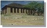
Today there are five adobe buildings at the town site. They were constructed circa 1904 and the largest building was probably the headquarters for the Santa Rita Water and Mining Company. Later, that same large building became the main ranch house as the land was used for cattle ranching. The small building behind the headquarters building was used to process gold samples, evidenced by liners that came from an assay furnace. Opposite a small house where Stetson may have lived are the remains of a ruined barn and another small adobeAdobe
Adobe is a natural building material made from sand, clay, water, and some kind of fibrous or organic material , which the builders shape into bricks using frames and dry in the sun. Adobe buildings are similar to cob and mudbrick buildings. Adobe structures are extremely durable, and account for...
house remains at the far end of the site.
Preservation
Historic preservation has been underway at Kentucky Camp since 1991. The Forest Service has worked to stabilize the remaining buildings, including repairing roofs and walls in hopes of preventing further deterioration. Much of the work has been done by volunteers under the auspices of the Forest Service's Passport In Time program and the Friends of Kentucky Camp.When the USFS acquired the property the buildings were in bad shape. The roofs had to be repaired first to keep water run off from contacting the crumbling adobe walls. The project was made possible by a $10,000 donation from the producers of the 1989-1992 TV show The Young Riders
The Young Riders
The Young Riders is an American Western television series created by Ed Spielman that presents a fictionalized account of a group of young Pony Express riders based at the Sweetwater Station in the Nebraska Territory during the years leading up to the American Civil War...
, which happened to be shooting in the area.
As of 2005 the Forest Service planned to restore the buildings to their original appearance during the mining era.