

Katy Trail (Dallas)
Encyclopedia
Oak Lawn, Dallas
Oak Lawn is a neighborhood in Dallas, Texas , defined in Dallas City Ordinance 21859 as . The unofficial boundaries are Turtle Creek Boulevard, Central Expressway, the City of Highland Park, Inwood Road, and Harry Hines Boulevard. It is over in area...
areas of Dallas
Dallas, Texas
Dallas is the third-largest city in Texas and the ninth-largest in the United States. The Dallas-Fort Worth Metroplex is the largest metropolitan area in the South and fourth-largest metropolitan area in the United States...
, Texas
Texas
Texas is the second largest U.S. state by both area and population, and the largest state by area in the contiguous United States.The name, based on the Caddo word "Tejas" meaning "friends" or "allies", was applied by the Spanish to the Caddo themselves and to the region of their settlement in...
(USA
United States
The United States of America is a federal constitutional republic comprising fifty states and a federal district...
), following the path of the old Missouri-Kansas-Texas Railroad
Missouri-Kansas-Texas Railroad
The Missouri–Kansas–Texas Railroad was incorporated May 23, 1870. In its earliest days the MKT was commonly referred to as "the K-T", which was its stock exchange symbol; this common designation soon evolved into "the Katy"....
, which was known as MKT or the Katy.
About
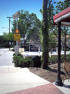
In Dallas, Texas, abandoned railroad tracks that once divided the downtown core are rapidly being transformed into the unifying Katy Trail, a linear 3.5 miles (5.6 km) long landscaped pedestrian, inline skating, and bicycle trail system that runs through the most densely developed section of the city. Construction started in Spring 2000. Several features have already been completed, including the 12 feet (3.7 m)-wide primary trail, two of four new entrance plazas, and four of the six planned pedestrian bridges. Construction was completed in 2007 on the Thomsen Overlook plaza overlooking Reverchon Park. An 8 feet (2.4 m)-wide secondary jogging trail only has 1 miles (1.6 km) left of construction, which will be completed once more funding is secured. The work is being carried out by The Friends of Katy Trail under a Master Plan created by The SWA Group office in Dallas.The trail consists of a 12 feet (3.7 m) wide concrete path for pedestrian
Pedestrian
A pedestrian is a person traveling on foot, whether walking or running. In some communities, those traveling using roller skates or skateboards are also considered to be pedestrians. In modern times, the term mostly refers to someone walking on a road or footpath, but this was not the case...
s and cyclists that runs 3.5 miles (5.6 km) from the American Airlines Center
American Airlines Center
The American Airlines Center is a multi-purpose arena, located in the Victory Park neighborhood, near downtown Dallas, Texas.It is home to the Dallas Mavericks of the NBA, and the Dallas Stars of the NHL....
in Victory Park
Victory Park
Victory Park is a master planned development northwest of downtown Dallas, Texas and north of Spur 366 . It is along Interstate 35E, part of the Stemmons Corridor and Uptown....
to Mockingbird Station
Mockingbird Station
Mockingbird is a DART Light Rail station located in north Dallas, Texas at Mockingbird Lane and North Central Expressway . It opened in January 1997 and is a station on the , and Lines, serving the Mockingbird Station residential and retail development and nearby Southern Methodist...
(a DART
Dallas Area Rapid Transit
The Dallas Area Rapid Transit authority is a transit agency based in Dallas, Texas . It operates buses, light rail, commuter rail, and high-occupancy vehicle lanes in Dallas and 12 of its suburbs...
light rail
Light rail
Light rail or light rail transit is a form of urban rail public transportation that generally has a lower capacity and lower speed than heavy rail and metro systems, but higher capacity and higher speed than traditional street-running tram systems...
station) near Southern Methodist University
Southern Methodist University
Southern Methodist University is a private university in Dallas, Texas, United States. Founded in 1911 by the Methodist Episcopal Church, South, SMU operates campuses in Dallas, Plano, and Taos, New Mexico. SMU is owned by the South Central Jurisdiction of the United Methodist Church...
. Next to the concrete path, a soft recycled-rubber track is built parallel for runners.
This adaptive re-use of unused railroad tracks—long a public eyesore and nuisance—unifies several important Dallas districts and provides a major recreational amenity for the more than 300,000 people who live and work within a mile of the Trail. (The southernmost trailhead is just
0.5 miles (804.7 m) from downtown Dallas
Dallas, Texas
Dallas is the third-largest city in Texas and the ninth-largest in the United States. The Dallas-Fort Worth Metroplex is the largest metropolitan area in the South and fourth-largest metropolitan area in the United States...
at the American Airlines Center
American Airlines Center
The American Airlines Center is a multi-purpose arena, located in the Victory Park neighborhood, near downtown Dallas, Texas.It is home to the Dallas Mavericks of the NBA, and the Dallas Stars of the NHL....
.) This new, partly completed linear greenway already attracts pedestrians and nature-lovers, both Dallas residents and visitors.
The Katy Trail is also directly responsible for an upsurge in property values and retail/restaurant sales in adjacent neighborhoods and developments. The April 21, 2006, The Dallas Morning News
The Dallas Morning News
The Dallas Morning News is the major daily newspaper serving the Dallas, Texas area, with a circulation of 264,459 subscribers, the Audit Bureau of Circulations reported in September 2010...
called Katy Trail “one of our city’s favorite outdoor spaces.” Katy Trail has become such a popular jogging location that some Dallasites quip, “The trains don’t run here any more . . . Dallas does.”
History
The trail's life began when the Union Pacific RailroadUnion Pacific Railroad
The Union Pacific Railroad , headquartered in Omaha, Nebraska, is the largest railroad network in the United States. James R. Young is president, CEO and Chairman....
, which had bought the Katy, donated the abandoned lines to the city in 1993.
The train tracks that are now the location of the Katy Trail formed the major east-bound route through Dallas of the former Missouri-Kansas-Texas (MKT or “Katy”) Railroad, which shut down in the late 1980s. The stations, which had served Dallas residents on their trips back East for so many years, were torn down, but the tracks remained.
In the early 1980s The Katy was initially considered for DART's
Dallas Area Rapid Transit
The Dallas Area Rapid Transit authority is a transit agency based in Dallas, Texas . It operates buses, light rail, commuter rail, and high-occupancy vehicle lanes in Dallas and 12 of its suburbs...
Red
Red Line (Dallas Area Rapid Transit)
The Red Line is a light rail line in the system of mass transit in Dallas, Texas operated by the Dallas Area Rapid Transit system. Along with the , it is one of the original modern rail lines in Dallas....
and Blue
Blue Line (Dallas Area Rapid Transit)
The Blue Line is a light rail line in the system of mass transit in Dallas, Texas , operated by the Dallas Area Rapid Transit system. Along with the , it is one of the original modern rail lines in Dallas....
lines to the Northeast, but the current route beneath Central Expressway
Central Expressway (Dallas)
Central Expressway is a north–south highway in Dallas, Texas and surrounding areas.- North Central Expressway :The best-known section is the North Central Expressway, a name for a freeway section of U.S. Highway 75 between downtown Dallas and McKinney, Texas...
was chosen instead.
By the early 1990s, Dallas residents, business people, and city and county officials proposed restoring the greenbelt along the railroad route and creating an urban park as part of the national Rails to Trails Conservancy program, established in 1986 and based in Washington, D.C.
The Katy Trail is intended to provide an effective way of connecting the various city parks running from White Rock Lake
White Rock Lake
White Rock Lake is a reservoir located in east Dallas, Texas . The lake was formed by damming White Rock Creek, which today widens into the lake before continuing south out of the spillway and emptying into the Trinity River...
to the planned park system along the Trinity River
Trinity River (Texas)
The Trinity River is a long river that flows entirely within the U.S. state of Texas. It rises in extreme north Texas, a few miles south of the Red River. The headwaters are separated by the high bluffs on the south side of the Red River....
—it runs alongside Reverchon Park
Reverchon Park
Reverchon Park is a public park in the Oak Lawn area of Dallas, Texas . It lies along Turtle Creek and is adjacent to the Katy Trail. The main entrance to the park is at Maple Avenue and Turtle Creek Boulevard. Southern Methodist University baseball existed briefly at the ballpark from 1977-1980...
and the park system along Turtle Creek
Turtle Creek, Dallas
Turtle Creek is a neighborhood running along Turtle Creek and adjacent Turtle Creek Boulevard in the Oak Lawn area of Dallas, Texas .Turtle Creek has also become an adopted nickname for the Oak Lawn neighborhood, though never an official one...
.
Master plan
Originally, the Dallas Park & Recreation Department planned a basic concrete pathway system along the railroad right of way. The Friends of the Katy Trail have greatly expanded that vision by hiring The SWA Group, an international landscape architecture, planning, and urban design firm, to create a $23 million master plan for two trails and an urban park connecting the West End district to Mockingbird Station.When completed over the next few years, Katy Trail will have a 3.5 miles (5.6 km) long 12 feet (3.7 m) wide concrete path for bicyclists and in-line skaters, an adjacent 3.1 miles (5 km) long 8 feet (2.4 m) wide soft surface track for pedestrians, 4 major entrance plazas, ADA-compliant entrances, benches, landscaping, and drinking fountains for all users, including pets.
The planting plan is dominated by native Texas trees and plants, including Chinquapin
Chinquapin
-Plants:* Chinquapin or chinkapin, any of the shrubs in the genus Castanopsis* Chinquapin or chinkapin, any of the several trees and shrubs in the genus Chrysolepis* Chinquapin or chinkapin, some of the species in the chestnut genus Castanea...
and Lacey Oak
Lacey Oak
Quercus laceyi, the Lacey Oak, is a small to medium-size deciduous Oak tree which is native to NE Mexico and the Texas Hill Country in Texas, United States. It seldom grows more than 35 feet tall, and has a stocky trunk. Its blue-green leaves are oblong and unlobed; they turn yellow or brown in...
s, perennial grasses, Flame Acanthus, and numerous species of native salvia
Salvia
Salvia is the largest genus of plants in the mint family, Lamiaceae, with approximately 700-900 species of shrubs, herbaceous perennials, and annuals. It is one of several genera commonly referred to as sage. When used without modifiers, sage generally refers to Salvia officinalis ; however, it is...
s and other plans which support water conservation.
For years, the abandoned railroad tracks had been populated by the homeless, drug dealers, and gangs. The master plan includes strategies to transform negative public perceptions of the Katy Trail through landscaping, lighting, and particularly in the design of nine public spaces at important crossings and intersections. For night-time safety without adding light pollution
Light pollution
Light pollution, also known as photopollution or luminous pollution, is excessive or obtrusive artificial light.The International Dark-Sky Association defines light pollution as:...
, reflective shield lamps atop 25 feet (7.6 m)-poles direct light onto the trail. The public spaces have more intimate lighting and distinctive light fixtures.