
Kativik Regional Government
Encyclopedia
Kativik redirects here. For the statistical area, see Kativik (territory equivalent to a regional county municipality).
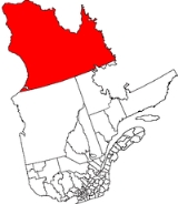
 The Kativik Regional Government (in French, Administration régionale Kativik) encompasses most of the Nunavik
region of Quebec
. Nunavik is the northern half of the Nord-du-Québec
administrative region and includes all the territory north of the 55th parallel
. The administrative capital is Kuujjuaq
, on the Koksoak River
, about 50 kilometers inland from the southern end of the Ungava Bay
.
Created in 1978 in accordance with the James Bay and Northern Quebec Agreement
, the Kativik Regional Government is elected by all the inhabitants of the Nunavik region, both Inuit
and non-Inuit. The Regional Government is financed by the Government of Québec (50%) and the Government of Canada (25%).
The Cree village Whapmagoostui
, near the northern village of Kuujjuarapik
, on the eastern shore of Hudson Bay
, is an enclave in the Nunavik region and its inhabitants do not participate in the Kativik Regional Government. Whapmagoostui (village and reserved lands: 316 km²) is part of the Cree Regional Authority and the Grand Council of the Cree (Eeyou Istchee).
The Kativik Regional Government includes 14 northern villages, 14 Inuit reserved lands and one Naskapi reserved land. Each Inuit reserved land is near a northern village; the Naskapi reserved land is near the village of Kawawachikamach, south of the 55th parallel in the Côte-Nord
region of Québec. The Kativik Regional Government covers a territory of about 500,000 km² and includes a population of just over 10,000 persons, of which about 90% are Inuit.
The Inuit
of Nunvavik are also represented by the Makivik Corporation
in their relations with the governments of Quebec and Canada on issues specifically pertaining to their indigenous rights (hunting and land use). The Makivik corporation favors greater autonomy for the Nunavik region and is headquartered in Kuujjuaq.
Nunavik
Nunavik comprises the northern third of the province of Quebec, Canada. Covering a land area of 443,684.71 km² north of the 55th parallel, it is the homeland of the Inuit of Quebec...
region of Quebec
Quebec
Quebec or is a province in east-central Canada. It is the only Canadian province with a predominantly French-speaking population and the only one whose sole official language is French at the provincial level....
. Nunavik is the northern half of the Nord-du-Québec
Nord-du-Québec
Nord-du-Québec is the largest of the seventeen administrative regions of Quebec, Canada. With , of which are lakes and rivers, it covers much of the Labrador Peninsula and about 55% of the total land surface area of Quebec....
administrative region and includes all the territory north of the 55th parallel
55th parallel north
The 55th parallel north is a circle of latitude that is 55 degrees north of the Earth's equatorial plane. It crosses Europe, Asia, the Pacific Ocean, North America, and the Atlantic Ocean....
. The administrative capital is Kuujjuaq
Kuujjuaq, Quebec
Kuujjuaq is the largest Inuit village in Nunavik, Quebec, Canada with a population of 2,132 as of the 2006 census. This is up roughly 10% from 1,932 as of the 2001 Census. It is the administrative capital of Nunavik and lies on the western shore of the Koksoak River.Kuujjuaq previously was known...
, on the Koksoak River
Koksoak River
The Koksoak River is a river in northern Quebec, Canada, the largest river in the Nunavik region. The Inuit village and region's administrative center Kuujjuaq lies on the shores of the Koksoak, about south from its mouth.The name Koksoak is believed to originate from Moravian missionaries who...
, about 50 kilometers inland from the southern end of the Ungava Bay
Ungava Bay
Ungava Bay is a large bay in northeastern Canada separating Nunavik from Baffin Island. The bay is shaped like a rounded square with a side length of about and has an area of approximately...
.
Created in 1978 in accordance with the James Bay and Northern Quebec Agreement
James Bay and Northern Quebec Agreement
The James Bay And Northern Quebec Agreement was an Aboriginal land claim settlement, approved in 1975 by the Cree and Inuit of northern Quebec, and later slightly modified in 1978 by the Northeastern Quebec Agreement, through which Quebec's Naskapi First Nations joined the treaty...
, the Kativik Regional Government is elected by all the inhabitants of the Nunavik region, both Inuit
Inuit
The Inuit are a group of culturally similar indigenous peoples inhabiting the Arctic regions of Canada , Denmark , Russia and the United States . Inuit means “the people” in the Inuktitut language...
and non-Inuit. The Regional Government is financed by the Government of Québec (50%) and the Government of Canada (25%).
The Cree village Whapmagoostui
Whapmagoostui, Quebec
Whapmagoostui |beluga]]") is the northernmost Cree village in Quebec, located at the mouth of the Great Whale River on the coast of Hudson Bay in Nunavik, Quebec, Canada. About 500 people, mostly Inuit, live in the neighbouring northern village of Kuujjuarapik. The community is only accessible by...
, near the northern village of Kuujjuarapik
Kuujjuarapik, Quebec
Kuujjuarapik is the southernmost Inuit village at the mouth of the Great Whale River on the coast of Hudson Bay in Nunavik, Quebec, Canada. About 800 people, mostly Cree, live in the adjacent village of Whapmagoostui. The community is only accessible by air and, in late summer, by boat...
, on the eastern shore of Hudson Bay
Hudson Bay
Hudson Bay , sometimes called Hudson's Bay, is a large body of saltwater in northeastern Canada. It drains a very large area, about , that includes parts of Ontario, Quebec, Saskatchewan, Alberta, most of Manitoba, southeastern Nunavut, as well as parts of North Dakota, South Dakota, Minnesota,...
, is an enclave in the Nunavik region and its inhabitants do not participate in the Kativik Regional Government. Whapmagoostui (village and reserved lands: 316 km²) is part of the Cree Regional Authority and the Grand Council of the Cree (Eeyou Istchee).
The Kativik Regional Government includes 14 northern villages, 14 Inuit reserved lands and one Naskapi reserved land. Each Inuit reserved land is near a northern village; the Naskapi reserved land is near the village of Kawawachikamach, south of the 55th parallel in the Côte-Nord
Côte-Nord
Côte-Nord is the second largest administrative region by land area in Quebec, Canada, after Nord-du-Québec...
region of Québec. The Kativik Regional Government covers a territory of about 500,000 km² and includes a population of just over 10,000 persons, of which about 90% are Inuit.
The Inuit
Inuit
The Inuit are a group of culturally similar indigenous peoples inhabiting the Arctic regions of Canada , Denmark , Russia and the United States . Inuit means “the people” in the Inuktitut language...
of Nunvavik are also represented by the Makivik Corporation
Makivik Corporation
The Makivik Corporation is the legal representative of Quebec's Inuit people, established in 1978 under the terms of the James Bay and Northern Quebec Agreement, the agreement that established the institutions of Nunavik...
in their relations with the governments of Quebec and Canada on issues specifically pertaining to their indigenous rights (hunting and land use). The Makivik corporation favors greater autonomy for the Nunavik region and is headquartered in Kuujjuaq.