

Johnson Mesa
Encyclopedia
Johnson Mesa is a prominent mesa
in Colfax County
in northeastern New Mexico
just south of the Colorado
border. The city of Raton
is on the west and Folsom
on the east.
Johnson Mesa is a high plateau with a top-of-the-world atmosphere looking out over the Great Plains
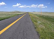
far below. New Mexico Highway 72 traverses the mesa east to west, part of the Dry Cimarron State Scenic & Historic Byway. Several volcanic cones, including Red Mountain, Towndrow Peak, and Dale Mountain rise about 400 feet (122 mts) above the mostly flat and treeless terrain. The cliffs surrounding the mesa are wooded with Pinyon, Juniper
, and Ponderosa Pine
, but the top is grassland. The source of the Dry Cimarron River is on the Mesa, but, before the coming of settlers, the only water sources were depressions in which water collected after rains. Several shallow lakes and ponds, including Berry and Bellisle lakes, have been created as watering holes for cattle. Below the south rim of Johnson Mesa is Johnson Park, about 3 miles (5 km) by 2 miles (3 km), at an elevation of 6,800 feet (2,073 mts). The earliest access to the Mesa was through the Park.
The high altitude moderates summer temperatures, but winters are very cold and windy. The Mesa receives about 18 inches (457 mm) of precipitation annually as does nearby Raton.
 There is no achaeological evidence that American Indians inhabited the Mesa although just below the eastern rim of the Mesa in Wild Horse Arroyo
the first trace of early man in the Americas was discovered.
The first White settler was Elijah (Lige) Johnson who established a ranch in Johnson Park about 1882 and pastured cattle on the Mesa. Grazing on top of mesas was a traditional practice throughout northern New Mexico
, where some mesas to this day are known as potrero
s. About 1887, Marion Bell, railway construction worker, led a group of dissatisfied and unemployed railroad workers and coal miners from Blossberg (near Raton) and began homesteading
the Mesa. The settlers congregated around the home of Lon Bell and the post office of Bell was established here. Soon the entire mesa was full of homesteads, each with their 160 acres of free land
The community of Bell and Johnson Mesa peaked in population about 1900 with 487 residents. Bell had a Methodist Church and a cemetery, five schools were scattered around the Mesa, and the residents of the mesa held annual celebrations on July 4 and August 14, the date the church was dedicated. The principal crops raised in the fertile volcanic soils of the Mesa were oats, potatoes, vegetables, and hay. Many of the men worked at both farming and coal mining. Carrier pigeons were dispatched from the mines to the top of the Mesa when workers were needed.
The long, cold winters defeated many farmers and by 1910 the population had dropped to 335. By 1920 after an influenza epidemic it was only 215 and by 1950 it had fallen to 56. The Post Office at Bell was closed in 1933. Today, nobody lives on Johnson Mesa year round although some ranchers pass the summer here tending their cattle. Surviving at Bell is a cemetery and St. John's Methodist Episcopal Church, dating from 1897.
Mesa
A mesa or table mountain is an elevated area of land with a flat top and sides that are usually steep cliffs. It takes its name from its characteristic table-top shape....
in Colfax County
Colfax County, New Mexico
-2010:Whereas according to the 2010 U.S. Census Bureau:*83.8% White*0.5% Black*1.5% Native American*0.4% Asian*0.1% Native Hawaiian or Pacific Islander*3.6% Two or more races*10.1% Other races*47.2% Hispanic or Latino -2000:...
in northeastern New Mexico
New Mexico
New Mexico is a state located in the southwest and western regions of the United States. New Mexico is also usually considered one of the Mountain States. With a population density of 16 per square mile, New Mexico is the sixth-most sparsely inhabited U.S...
just south of the Colorado
Colorado
Colorado is a U.S. state that encompasses much of the Rocky Mountains as well as the northeastern portion of the Colorado Plateau and the western edge of the Great Plains...
border. The city of Raton
Raton, New Mexico
Raton is a city in Colfax County, New Mexico, United States. The population was 7,282 at the 2000 census. It is the county seat of Colfax County. The city is located just south of Raton Pass.-Name:...
is on the west and Folsom
Folsom, New Mexico
Folsom is a village in Union County, New Mexico, United States. The population was 75 at the 2000 census. The town was named after Frances Folsom, the fiancee of President Grover Cleveland.-Geography:Folsom is located at ....
on the east.
Description
Johnson Mesa is about 14 miles (22.5 km) long, running east to west, and 2 miles (3.2 km) to 6 miles (9.7 km) wide, north to south. The lava-topped tableland slopes downward from 8,650 feet (2,637 mts) to 7,600 feet (2,316 mts) from west to east. Steep-sides and ciffs from 500 feet (152 mts) to 1,900 feet (579 mts) high ring the Mesa.Johnson Mesa is a high plateau with a top-of-the-world atmosphere looking out over the Great Plains
Great Plains
The Great Plains are a broad expanse of flat land, much of it covered in prairie, steppe and grassland, which lies west of the Mississippi River and east of the Rocky Mountains in the United States and Canada. This area covers parts of the U.S...
far below. New Mexico Highway 72 traverses the mesa east to west, part of the Dry Cimarron State Scenic & Historic Byway. Several volcanic cones, including Red Mountain, Towndrow Peak, and Dale Mountain rise about 400 feet (122 mts) above the mostly flat and treeless terrain. The cliffs surrounding the mesa are wooded with Pinyon, Juniper
Juniper
Junipers are coniferous plants in the genus Juniperus of the cypress family Cupressaceae. Depending on taxonomic viewpoint, there are between 50-67 species of juniper, widely distributed throughout the northern hemisphere, from the Arctic, south to tropical Africa in the Old World, and to the...
, and Ponderosa Pine
Ponderosa Pine
Pinus ponderosa, commonly known as the Ponderosa Pine, Bull Pine, Blackjack Pine, or Western Yellow Pine, is a widespread and variable pine native to western North America. It was first described by David Douglas in 1826, from eastern Washington near present-day Spokane...
, but the top is grassland. The source of the Dry Cimarron River is on the Mesa, but, before the coming of settlers, the only water sources were depressions in which water collected after rains. Several shallow lakes and ponds, including Berry and Bellisle lakes, have been created as watering holes for cattle. Below the south rim of Johnson Mesa is Johnson Park, about 3 miles (5 km) by 2 miles (3 km), at an elevation of 6,800 feet (2,073 mts). The earliest access to the Mesa was through the Park.
The high altitude moderates summer temperatures, but winters are very cold and windy. The Mesa receives about 18 inches (457 mm) of precipitation annually as does nearby Raton.
History
Wild Horse Arroyo
Wild Horse Arroyo is an archeological site which was excavated in 1926 near Folsom, New Mexico. This site is significant because it was the first time that artifacts indisputably made by humans were found directly associated with faunal remains from an extinct form of bison from the Late Pleistocene...
the first trace of early man in the Americas was discovered.
The first White settler was Elijah (Lige) Johnson who established a ranch in Johnson Park about 1882 and pastured cattle on the Mesa. Grazing on top of mesas was a traditional practice throughout northern New Mexico
Northern New Mexico
Northern New Mexico may simply mean the northern part of New Mexico, but in cultural terms it usually means the area of heavy Spanish settlement in the north-central part....
, where some mesas to this day are known as potrero
Potrero
-See also:*Potrero Hill, San Francisco, a neighborhood in San Francisco, California, USA*Potrero Chico, a rock climbing area in Mexico*Potrero Point, a land mass extending into San Francisco Bay, San Francisco, California*Point Potrero, Richmond, California...
s. About 1887, Marion Bell, railway construction worker, led a group of dissatisfied and unemployed railroad workers and coal miners from Blossberg (near Raton) and began homesteading
Homestead Act
A homestead act is one of three United States federal laws that gave an applicant freehold title to an area called a "homestead" – typically 160 acres of undeveloped federal land west of the Mississippi River....
the Mesa. The settlers congregated around the home of Lon Bell and the post office of Bell was established here. Soon the entire mesa was full of homesteads, each with their 160 acres of free land
The community of Bell and Johnson Mesa peaked in population about 1900 with 487 residents. Bell had a Methodist Church and a cemetery, five schools were scattered around the Mesa, and the residents of the mesa held annual celebrations on July 4 and August 14, the date the church was dedicated. The principal crops raised in the fertile volcanic soils of the Mesa were oats, potatoes, vegetables, and hay. Many of the men worked at both farming and coal mining. Carrier pigeons were dispatched from the mines to the top of the Mesa when workers were needed.
The long, cold winters defeated many farmers and by 1910 the population had dropped to 335. By 1920 after an influenza epidemic it was only 215 and by 1950 it had fallen to 56. The Post Office at Bell was closed in 1933. Today, nobody lives on Johnson Mesa year round although some ranchers pass the summer here tending their cattle. Surviving at Bell is a cemetery and St. John's Methodist Episcopal Church, dating from 1897.