
Jirisan
Encyclopedia
Jirisan is a mountain in the southern region of South Korea
. It is often considered one of the three most important mountains in South Korea (the mainland highest point), with Hallasan
and Seoraksan
being the other two.
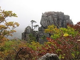
The mountain rises to 1915 metres above sea level and is located in a designated national park of the same name. Jirisan National Park
spans three provinces: North, South Jeolla and South Gyeongsang and is the largest in Korea. The largest proportion of the national park is in the province of South Gyeongsang. The highest peak of the mountain, Cheonhwangbong is also located in this province. Another well-known peak is Samshin-bong (Three Spirits Peak).
Jirisan is considered the southern end of the Sobaek
mountain range, and therefore also the southern end of the Baekdudaegan
mountain range, the "spine" of the Korean Peninsula
incorporating the Sobaek
mountain range and most of the Taebaek
mountain range.
There are seven Buddhist temples on Jirisan that are considered major Buddhist temples. Hwaeomsa
is the largest and best-known temple among these, and contains a number of national treasures (mostly stone artworks from about 600–900 CE). The mountain is also home to the Cheonghak-dong (Azure Crane Village) alpine valley, which includes the Samseong-gung (Three Sages Palace), which is a recently-developed site to celebrate one of Korea's foundation myths.
Jirisan is the most loved mountain in South Korea. Every year more than 280,000 people visit Jirisan during all of four seasons. Especially summer and fall seasons are popular to those people who want to spend summer vacation and want to enjoy the beauty of autumn colors of mountain. It has ten scenic views which are ‘Sunrise from Cheonwang-bong peak’, ‘Nogodan Sea of Clouds’, 'Banyabong’s Nakjo’, ‘Full moon at Byukso-ryung’, ‘Piagol Autumn Leaves’, ‘Royal Azalea Blossoming’, ‘Chilseon Valley’, ‘Seomjincheongryu’, ‘Buril water fall’, ‘Yeonha-Sunkyung’. These are memorable and breathtaking for hikers. Jirisan National Park has numbers of routes for hikers to enjoy the beautiful sceneries and also has few regulations to reserve its nature by emphasizing Eco-Tourism.
(the sa suffix indicates a Buddhist temple), the peak can be reached in 4 hours at a steady pace. It takes about 3 hours to get down; it is an extremely steep hike. Climbers are advised to bring plenty of water as it is only available from streams beyond the temple grounds. This peak can also be climbed from the back of Cheonghak-dong Village.
South Korea
The Republic of Korea , , is a sovereign state in East Asia, located on the southern portion of the Korean Peninsula. It is neighbored by the People's Republic of China to the west, Japan to the east, North Korea to the north, and the East China Sea and Republic of China to the south...
. It is often considered one of the three most important mountains in South Korea (the mainland highest point), with Hallasan
Hallasan
Hallasan is a shield volcano on Jeju Island of South Korea. Hallasan is the highest mountain of South Korea. The area around the mountain is a designated national park, the Hallasan National Park...
and Seoraksan
Seoraksan
Seoraksan is the highest mountain in the Taebaek mountain range in the Gangwon province in eastern South Korea. It is located in a national park near the city of Sokcho. After the Hallasan volcano on Jeju Island and Jirisan in the south, Seoraksan is the third highest mountain in South Korea. The...
being the other two.
The mountain rises to 1915 metres above sea level and is located in a designated national park of the same name. Jirisan National Park
Jirisan National Park
Jirisan National Park is a national park in South Korea, located on the boundaries of Jeollanam-do, Jeollabuk-do, and Gyeongsangnam-do. Jirisan was the first park to be designated as a national park in South Korea, in 1967...
spans three provinces: North, South Jeolla and South Gyeongsang and is the largest in Korea. The largest proportion of the national park is in the province of South Gyeongsang. The highest peak of the mountain, Cheonhwangbong is also located in this province. Another well-known peak is Samshin-bong (Three Spirits Peak).
Jirisan is considered the southern end of the Sobaek
Sobaek Mountains
The Sobaek Mountains are a mountain range cutting across the southern Korean peninsula. They split off from the Taebaek Mountains and trend southwest across the center of the peninsula. They are traditionally considered to reach their southwestern limit at Jirisan, which is also the highest peak...
mountain range, and therefore also the southern end of the Baekdudaegan
Baekdudaegan
The Baekdudaegan is a mountain range and watershed-crest-line which runs through most of the length of the Korean Peninsula, from Baekdu Mountain in the north to Jirisan in the south. It is important in traditional Korean thought, a key aspect of Pungsujiri philosophy and practices...
mountain range, the "spine" of the Korean Peninsula
Korean Peninsula
The Korean Peninsula is a peninsula in East Asia. It extends southwards for about 684 miles from continental Asia into the Pacific Ocean and is surrounded by the Sea of Japan to the south, and the Yellow Sea to the west, the Korea Strait connecting the first two bodies of water.Until the end of...
incorporating the Sobaek
Sobaek Mountains
The Sobaek Mountains are a mountain range cutting across the southern Korean peninsula. They split off from the Taebaek Mountains and trend southwest across the center of the peninsula. They are traditionally considered to reach their southwestern limit at Jirisan, which is also the highest peak...
mountain range and most of the Taebaek
Taebaek Mountains
The Taebaek Mountains are a mountain range in both North Korea and South Korea. They form the main ridge of the Korean peninsula.-Geography:...
mountain range.
There are seven Buddhist temples on Jirisan that are considered major Buddhist temples. Hwaeomsa
Hwaeomsa
Hwaeomsa is a head temple of the Jogye Order of Korean Buddhism. It is located on the slopes of Jiri-san, in Masan-myeon, Gurye County, in the province of Jeollanam-do, South Korea...
is the largest and best-known temple among these, and contains a number of national treasures (mostly stone artworks from about 600–900 CE). The mountain is also home to the Cheonghak-dong (Azure Crane Village) alpine valley, which includes the Samseong-gung (Three Sages Palace), which is a recently-developed site to celebrate one of Korea's foundation myths.
Jirisan is the most loved mountain in South Korea. Every year more than 280,000 people visit Jirisan during all of four seasons. Especially summer and fall seasons are popular to those people who want to spend summer vacation and want to enjoy the beauty of autumn colors of mountain. It has ten scenic views which are ‘Sunrise from Cheonwang-bong peak’, ‘Nogodan Sea of Clouds’, 'Banyabong’s Nakjo’, ‘Full moon at Byukso-ryung’, ‘Piagol Autumn Leaves’, ‘Royal Azalea Blossoming’, ‘Chilseon Valley’, ‘Seomjincheongryu’, ‘Buril water fall’, ‘Yeonha-Sunkyung’. These are memorable and breathtaking for hikers. Jirisan National Park has numbers of routes for hikers to enjoy the beautiful sceneries and also has few regulations to reserve its nature by emphasizing Eco-Tourism.
Legends
At the entrance to Baemsagol Valley, some 1,300 years ago, there used to be Songnimsa Temple. This temple practiced an annual rite on the Chilwolbaekjung holiday (full moon day of July by the lunar calendar) wherein they selected the most pious monk and prayed earnestly for his safe passage to paradise as a deity. In a certain year, the then highest monk Seosandaesa visited the temple, heard about this Buddhist rite, and guessed that there must be a secret behind it. Seosandesa allowed that year’s chosen monk to pray wearing a silk robe anointed with poison, linked by a silk thread to Sinseodae Terrace. Seosandaesa then hid himself behind a rock to watch. At around 1 am, an imugi (anaconda, which was sorry not to have turned into a dragon, slithered up from the valley below Sinseondae Terrace to the sound of roaring water. The imugi jumped upon the praying monk, bit him in the mouth, and disappeared into the water. Seosandaesa returned to the temple, and waited until dawn. Early in the morning, he, together with the villagers, went to Sinseondae Terrace to find that the imugi had died dead, having failed to swallow the whole body of the monk. Seosandaesa now came to know about Songnimsa Temple’s secret of sacrificing a monk to an imugi every year. Thereafter, the valley was named as Baemsagol, which means the valley where an imugi, which failed to become a dragon, died. The village at the entrance to Baemsagol Valley was named Banseon (meaning a “half deity”) in memory of the dead monk because he was sacrificed without becoming a deity.Peaks
Samshinbong (bong means "peak") is 1,284 meters high and a popular, but strenuous, day-hike from the Ssanggye Temple entry point (it is the closest major peak from this trailhead). From Ssanggyesa, a trail winds up 2.3 km to Bul-il Falls. From the left turn in the path just before the waterfall, the track continues 6.9 km to the peak (for a grand round-trip total of 18.4 km). Starting from SsanggyesaSsanggyesa
Ssanggyesa is a head temple of the Jogye Order of Korean Buddhism. It is located on the southern slopes of Jirisan, southwest of sacred Samshin-bong Peak, in the Hwagye-dong Valley of Hwagae-myeon, Hadong County, in the province of Gyeongsangnam-do, South Korea.The temple was founded in 722 by two...
(the sa suffix indicates a Buddhist temple), the peak can be reached in 4 hours at a steady pace. It takes about 3 hours to get down; it is an extremely steep hike. Climbers are advised to bring plenty of water as it is only available from streams beyond the temple grounds. This peak can also be climbed from the back of Cheonghak-dong Village.
See also
- National parks of South KoreaNational parks of South KoreaThe national parks of South Korea are preserved parcels of public land in South Korea, on which most forms of development are prohibited. They cover a total of 3.7% of the country's area, and are typically located in mountainous or coastal regions...
- List of Korea-related topics
- List of mountains in Korea
- Geography of South KoreaGeography of South KoreaSouth Korea is located in East Asia, on the southern half of the Korean Peninsula jutting out from the far east of the Asian land mass. The only country with a land border to South Korea is North Korea, lying to the north with of border running along the DMZ. South Korea is mostly surrounded by...
External links
- Jirisan National Park-Official KNPS Homepage
- Online mashup/interactive map of Jirisan hiking trails (in Korean)
- Korea in the Clouds: A Detailed Guide to Hiking Korea's Mountains
- Jiri-san as a Sacred Mountain, Mason's pages on the religious character and sites of this remarkable set of peaks, slopes and gorges.