
Jefferson, Colorado
Encyclopedia
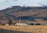
Jefferson is an unincorporated town
and a U.S. Post Office
in Park County
, Colorado
, United States
. It is located the northern end of South Park
, along U.S. Route 285
, approximately 15 miles (24 km) northeast of Fairplay
, at the western foot of Kenosha Pass
. It lies 6 miles (10 km) from Como
, 23 miles (37 km) from Bailey
, and 37 miles (60 km) from Breckenridge
. The town consists largely of a strip of retail businesses along U.S. Route 285, as well as a small unpaved grid of houses and trailers on the south side of the highway. The most notable landmark in town is a historic one-room schoolhouse, highly visible in the surrounding grasslands of South Park. The Jefferson Post Office has the ZIP Code
80456.
Unincorporated area
In law, an unincorporated area is a region of land that is not a part of any municipality.To "incorporate" in this context means to form a municipal corporation, a city, town, or village with its own government. An unincorporated community is usually not subject to or taxed by a municipal government...
and a U.S. Post Office
United States Postal Service
The United States Postal Service is an independent agency of the United States government responsible for providing postal service in the United States...
in Park County
Park County, Colorado
Park County is the 17th most extensive of the 64 counties of the State of Colorado of the United States. The county was named after the large geographic region known as South Park, which was named by early fur traders and trappers in the area. The geographic center of the State of Colorado is...
, Colorado
Colorado
Colorado is a U.S. state that encompasses much of the Rocky Mountains as well as the northeastern portion of the Colorado Plateau and the western edge of the Great Plains...
, United States
United States
The United States of America is a federal constitutional republic comprising fifty states and a federal district...
. It is located the northern end of South Park
South Park (Colorado basin)
South Park is a high intermontane grassland basin, approximately 10,000 ft in elevation, in the Rocky Mountains of central Colorado. It encompasses approximately 1,000 square miles around the headwaters of the South Platte River in Park County approximately 60 mi southwest of Denver...
, along U.S. Route 285
U.S. Route 285
U.S. Route 285 is a north–south United States highway, running 845 miles through the states of Texas, New Mexico and Colorado. The highway's northern terminus is in Denver, Colorado, at exit 201 on Interstate 25. Its southern terminus is in Sanderson, Texas at an intersection with U.S....
, approximately 15 miles (24 km) northeast of Fairplay
Fairplay, Colorado
The Town of Fairplay is a statutory town that is the county seat and the most populous town of Park County, Colorado, United States. Fairplay is located in South Park at an elevation of . The town is the fifth-highest incorporated place in the State of Colorado. The population was 610 at the...
, at the western foot of Kenosha Pass
Kenosha Pass
Kenosha Pass, elevation , is a high mountain pass located in the Rocky Mountains of central Colorado in the United States.The pass is located in the Rocky Mountains southwest of Denver, Colorado, just northeast of the town of Fairplay, Colorado...
. It lies 6 miles (10 km) from Como
Como, Colorado
Como is an unincorporated town and a U.S. Post Office in Park County, Colorado, United States. The Como Post Office has the ZIP Code 80432.Located at the northern end of South Park, the town is a historic mining settlement founded during the Pike's Peak Gold Rush in 1859. It sits approximately...
, 23 miles (37 km) from Bailey
Bailey, Colorado
Bailey is an unincorporated town and U.S. Post Office in northeastern Park County, Colorado, United States.The ZIP Code of the Bailey Post Office is 80421. Bailey is in the Mountain Time Zone. The community is located along U.S...
, and 37 miles (60 km) from Breckenridge
Breckenridge, Colorado
Established in 1859, the historic town of Breckenridge is a home rule municipality that is the county seat of Summit County, Colorado, United States. As of the 2010 Census, the town had a population of 4,540. The town also has many part-time residents, as many people have vacation homes in the area...
. The town consists largely of a strip of retail businesses along U.S. Route 285, as well as a small unpaved grid of houses and trailers on the south side of the highway. The most notable landmark in town is a historic one-room schoolhouse, highly visible in the surrounding grasslands of South Park. The Jefferson Post Office has the ZIP Code
ZIP Code
ZIP codes are a system of postal codes used by the United States Postal Service since 1963. The term ZIP, an acronym for Zone Improvement Plan, is properly written in capital letters and was chosen to suggest that the mail travels more efficiently, and therefore more quickly, when senders use the...
80456.