
Jamestown, Rhode Island
Encyclopedia
Jamestown is a town
located in Newport County
, Rhode Island
, in the United States
. The population was 5,405 at the 2010 census
. Jamestown is situated almost entirely on Conanicut Island
, the second largest island in Narragansett Bay
.
. The rising sea forced humans to higher elevations, and submerged most traces of the earliest inhabitants. The oldest human artifacts found on Conanicut Island
date from around 3000 BC.
In 1524, the Italian navigator Giovanni da Verrazzano and his crew visited Narragansett Bay. In 1636 or 1637, "Dutch Island" was used by fur traders. In 1638 the English made arrangements to use Conanicut Island for grazing sheep.
 Ferries were in operation between Conanicut Island and Newport
by 1675. In 1678, Conanicut Island was incorporated as the town of Jamestown. There were about 150 residents. The town was named for James, Duke of York
, who would become King James II in 1685.
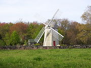
By 1710, many of Conanicut Island's current roads were in place. In 1728, the town of Jamestown built a windmill for grinding corn, which used the sea breeze for power since there was no source of running water to turn a waterwheel.
On December 10, 1775, 200 British and Hessian troops landed at East Ferry on Conanicut Island and marched to West Ferry, where they burned the ferry house. As they returned to East Ferry, they destroyed many buildings, including fourteen homes; which caused more than 200 of Conanicut Island's 556 residents to flee to the mainland.
In December, 1776, a British fleet arrived in Narragansett Bay and occupied Newport. The British took over the colonial militia batteries at Fort Dumpling (now part of Fort Wetherill
) and the Conanicut Battery at Beavertail (just south of Fort Getty, at the end of Battery Lane). The British left Narragansett Bay in October 1779. As they departed, they destroyed the fortifications they had occupied, and burned Beavertail lighthouse.
By 1784, Beavertail Light was back in operation. In 1787, Jamestown rebuilt the Jamestown Windmill
and Quaker Meetinghouse
that had been destroyed during the occupation.
 In 1800 Fort Dumpling was established on the site of previous fortifications overlooking East Passage. A tall stone tower atop the highest cliff could hold eight guns.
In 1872, the town of Jamestown commissioned a steam powered ferryboat. In May 1873, service was initiated between Jamestown and Newport. The availability of reliable and comfortable ferry service to and from Newport had a significant impact on agricultural Conanicut Island. Jamestown became a destination for both day trips and summer vacations.
The 1880s and 1890s saw a construction boom, with hotels, private summer homes and municipal buildings going up. The island's population tripled between 1870 and 1900.
There was a burst of military fortification activity from 1890 to the end of World War I
. The Spanish-American War
, which began in 1898, was a catalyst. Work on Dutch Island's Fort Grebel began. The War Department bought 31 acres (125,452.7 m²) for Fort Getty
and fortifications were quickly erected. Summer homes were condemned near Fort Dumpling to establish Fort Wetherill
. More land was acquired at Prospect Hill, near the Conanicut Battery site, for an observation and fire control station. The Government established a torpedo station and test facility on Gould Island. Then, at the end of the First World War, the Conanicut Island fortifications fell into disuse.
 Meanwhile, Jamestown was a bustling summer destination. In 1903, it had nine hotels. But the golden age of large resort hotels was brief in Jamestown and elsewhere. Patronage rapidly declined in the nineteen-twenties. The Thorndike Hotel was demolished in 1938.
In 1938 a major hurricane caused much property damage and the loss of more than 300 lives in the Narragansett Bay region. It swept much of the sand from the Mackerel Cove beach, destroyed its popular Beach Pavilion and speeded approvals for a bridge to Saunderstown by destroying the West Ferry docks. The first Jamestown Bridge
opened in the summer of 1940, replacing West Ferry service with a continuously available link to the west.
In 1941 the Gardner House, one of the larger hotels, was taken down after being idle for several years. A USO building was constructed on its site. (After the war, the building was purchased by the town and is now known as the Community Center. It was extensively landscaped and remodeled in 2002.)
World War II
brought establishment or reactivatation of military bases around Narragansett Bay, including Forts Getty and Wetherill on Conanicut Island, Fort Greble on Dutch Island, a torpedo factory on Goat Island
and a torpedo station on Gould Island.
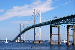
In 1969, the Newport (Pell) Bridge
was completed, establishing Route 138
as a continuous highway from South County to Newport. With its completion, traditional ferry service was eliminated. (The bridge is celebrated on the Rhode Island commemorative quarters.)
 The Bay View Hotel, the last of the very large hotels, ceased operation in the 1960s. The building was demolished in 1985. Four years later, the Bay View Condominiums opened for occupancy. The building exterior was carefully designed to closely resemble the hotel. The Bay Voyage Hotel, operating as a time share resort, is the only survivor of the many hotels that once lined Jamestown's eastern harbor area.
In 1992, the Jamestown-Verrazano Bridge
replaced the narrow steel bridge erected in 1940. It was accompanied by construction of a new western-end access road and a cross-Conanicut Island highway.
Portions of the films Me, Myself and Irene
, American General, Evening
, Dan in Real Life
and Moonrise Kingdom
were filmed in Jamestown, as well as in various nearby Aquidneck Island towns, such as Middletown and Newport.
 According to the United States Census Bureau
, the town has a total area of 35.3 square miles (91.4 km²), of which, 9.7 square miles (25.1 km²) of it is land and 25.6 square miles (66.3 km²) of it is water. The total area is 72.55% water.
of 2000, there are 5,622 people, 2,359 households, and 1,625 families residing in the town. The population density
is 580.0 people per square mile (224.0/km²). There are 2,769 housing units at an average density of 285.7 per square mile (110.3/km²). The racial makeup of the town is 97.55% White, 0.78% African American, 0.21% Native American, 0.39% Asian, 0.00% Pacific Islander, 0.23% from other races, and 0.84% from two or more races. 0.89% of the population are Hispanic or Latino of any race.
There are 2,359 households out of which 28.3% have children under the age of 18 living with them, 58.5% are married couples
living together, 8.0% have a female householder with no husband present, and 31.1% are non-families. 25.9% of all households are made up of individuals and 9.9% have someone living alone who was 65 years of age or older. The average household size is 2.38 and the average family size is 2.88.
In the town, the population is spread out with 22.0% under the age of 18, 4.3% from 18 to 24, 25.4% from 25 to 44, 33.5% from 45 to 64, and 14.7% who are 65 years of age or older. The median age is 44 years. For every 100 females, there are 94.6 males, and for every 100 females age 18 and over, there are 91.6 males.
The median income for a household in the town is $63,073, and the median income for a family is $77,990. Males have a median income of $50,185 versus $35,056 for females. The per capita income
for the town is $38,664. 2.9% of the population and 1.7% of families are below the poverty line. 1.4% of those under the age of 18 and 3.1% of those 65 and older are living below the poverty line.
, which formed south of the equator more than 565 million years ago.
Avalonia drifted northward; eventually colliding with Proto North America about 400 million years ago. The impact contributed most of the land that has become the New England states and created most of the northern Appalachians.
About 350 million years ago, North America and North Africa collided as part of the formation of a supercontinent, Pangaea. For more than 100 million years, Jamestown was located deep within the supercontinent. The layers of shale and coal that are common in the Narraganset Bay area were formed during this period. About 200 million years ago, Pangaea broke up, the Atlantic Ocean formed and slowly widened.
During the past 75,000 years, Jamestown was visited by glaciers at least twice. They gouged out channels in the Narragansett Basin and left deposits of rocks and soil throughout the area. The last glaciers left the area about 12,000 years ago. Sea level was hundreds of feet lower than today; but as additional glaciers melted around the world, the sea rose, covering the continental shelf and eventually filling Narragansett Bay.
New England town
The New England town is the basic unit of local government in each of the six New England states. Without a direct counterpart in most other U.S. states, New England towns are conceptually similar to civil townships in other states, but are incorporated, possessing powers like cities in other...
located in Newport County
Newport County, Rhode Island
-National protected areas:* Sachuest Point National Wildlife Refuge* Touro Synagogue National Historic Site-History:Newport County was constituted on June 22, 1703, as one of the two original counties of the Colony of Rhode Island and Providence Plantations. As originally established, Newport...
, Rhode Island
Rhode Island
The state of Rhode Island and Providence Plantations, more commonly referred to as Rhode Island , is a state in the New England region of the United States. It is the smallest U.S. state by area...
, in the United States
United States
The United States of America is a federal constitutional republic comprising fifty states and a federal district...
. The population was 5,405 at the 2010 census
United States Census, 2010
The Twenty-third United States Census, known as Census 2010 or the 2010 Census, is the current national census of the United States. National Census Day was April 1, 2010 and is the reference date used in enumerating individuals...
. Jamestown is situated almost entirely on Conanicut Island
Conanicut Island
Conanicut Island is the second largest island in Narragansett Bay, in the state of Rhode Island. It is connected on the east to Newport, Rhode Island, on Aquidneck Island by the Claiborne Pell Bridge, commonly known as the Newport Bridge, and on the west to North Kingstown, Rhode Island, on the...
, the second largest island in Narragansett Bay
Narragansett Bay
Narragansett Bay is a bay and estuary on the north side of Rhode Island Sound. Covering 147 mi2 , the Bay forms New England's largest estuary, which functions as an expansive natural harbor, and includes a small archipelago...
.
History
Humans arrived in the area about 10,000 to 12,000 years ago, at the end of the last ice age, when they settled near streams and rivers. Ongoing melting of glaciers caused the sea level to rise, covering low-lying areas and eventually filling Narragansett BayNarragansett Bay
Narragansett Bay is a bay and estuary on the north side of Rhode Island Sound. Covering 147 mi2 , the Bay forms New England's largest estuary, which functions as an expansive natural harbor, and includes a small archipelago...
. The rising sea forced humans to higher elevations, and submerged most traces of the earliest inhabitants. The oldest human artifacts found on Conanicut Island
Conanicut Island
Conanicut Island is the second largest island in Narragansett Bay, in the state of Rhode Island. It is connected on the east to Newport, Rhode Island, on Aquidneck Island by the Claiborne Pell Bridge, commonly known as the Newport Bridge, and on the west to North Kingstown, Rhode Island, on the...
date from around 3000 BC.
In 1524, the Italian navigator Giovanni da Verrazzano and his crew visited Narragansett Bay. In 1636 or 1637, "Dutch Island" was used by fur traders. In 1638 the English made arrangements to use Conanicut Island for grazing sheep.
Newport, Rhode Island
Newport is a city on Aquidneck Island in Newport County, Rhode Island, United States, about south of Providence. Known as a New England summer resort and for the famous Newport Mansions, it is the home of Salve Regina University and Naval Station Newport which houses the United States Naval War...
by 1675. In 1678, Conanicut Island was incorporated as the town of Jamestown. There were about 150 residents. The town was named for James, Duke of York
James II of England
James II & VII was King of England and King of Ireland as James II and King of Scotland as James VII, from 6 February 1685. He was the last Catholic monarch to reign over the Kingdoms of England, Scotland, and Ireland...
, who would become King James II in 1685.
By 1710, many of Conanicut Island's current roads were in place. In 1728, the town of Jamestown built a windmill for grinding corn, which used the sea breeze for power since there was no source of running water to turn a waterwheel.
On December 10, 1775, 200 British and Hessian troops landed at East Ferry on Conanicut Island and marched to West Ferry, where they burned the ferry house. As they returned to East Ferry, they destroyed many buildings, including fourteen homes; which caused more than 200 of Conanicut Island's 556 residents to flee to the mainland.
In December, 1776, a British fleet arrived in Narragansett Bay and occupied Newport. The British took over the colonial militia batteries at Fort Dumpling (now part of Fort Wetherill
Fort Wetherill
Fort Wetherill is a former Coast Artillery fort that occupied the southern portion of the eastern tip of Conanicut Island, located in Jamestown, Rhode Island. The fort sat atop high granite cliffs, overlooking the entrance to Narragansett Bay...
) and the Conanicut Battery at Beavertail (just south of Fort Getty, at the end of Battery Lane). The British left Narragansett Bay in October 1779. As they departed, they destroyed the fortifications they had occupied, and burned Beavertail lighthouse.
By 1784, Beavertail Light was back in operation. In 1787, Jamestown rebuilt the Jamestown Windmill
Jamestown Windmill
The Jamestown Windmill is a smock mill in Jamestown, Rhode Island within the Windmill Hill Historic District on North Road north of Weeden Lane....
and Quaker Meetinghouse
Friends Meetinghouse (Jamestown, Rhode Island)
The Friends Meetinghouse is a historic Quaker meeting house in Jamestown, Rhode Island in the Windmill Hill Historic District.The church was built in 1786 to replace the original meeting house destroyed by the British prior to the Battle of Rhode Island. The building was added to the National...
that had been destroyed during the occupation.
In 1872, the town of Jamestown commissioned a steam powered ferryboat. In May 1873, service was initiated between Jamestown and Newport. The availability of reliable and comfortable ferry service to and from Newport had a significant impact on agricultural Conanicut Island. Jamestown became a destination for both day trips and summer vacations.
The 1880s and 1890s saw a construction boom, with hotels, private summer homes and municipal buildings going up. The island's population tripled between 1870 and 1900.
There was a burst of military fortification activity from 1890 to the end of World War I
World War I
World War I , which was predominantly called the World War or the Great War from its occurrence until 1939, and the First World War or World War I thereafter, was a major war centred in Europe that began on 28 July 1914 and lasted until 11 November 1918...
. The Spanish-American War
Spanish-American War
The Spanish–American War was a conflict in 1898 between Spain and the United States, effectively the result of American intervention in the ongoing Cuban War of Independence...
, which began in 1898, was a catalyst. Work on Dutch Island's Fort Grebel began. The War Department bought 31 acres (125,452.7 m²) for Fort Getty
Fort Getty
Fort Getty is a town park in Jamestown, Rhode Island on Conanicut Island in Narragansett Bay.-History:Fort Getty was used as a U.S. Military fort during World War I and World War II. The State of Rhode Island later received the property and opened it as a state park.-Visiting today:Dutch Island...
and fortifications were quickly erected. Summer homes were condemned near Fort Dumpling to establish Fort Wetherill
Fort Wetherill
Fort Wetherill is a former Coast Artillery fort that occupied the southern portion of the eastern tip of Conanicut Island, located in Jamestown, Rhode Island. The fort sat atop high granite cliffs, overlooking the entrance to Narragansett Bay...
. More land was acquired at Prospect Hill, near the Conanicut Battery site, for an observation and fire control station. The Government established a torpedo station and test facility on Gould Island. Then, at the end of the First World War, the Conanicut Island fortifications fell into disuse.
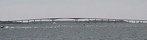
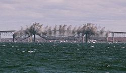
In 1938 a major hurricane caused much property damage and the loss of more than 300 lives in the Narragansett Bay region. It swept much of the sand from the Mackerel Cove beach, destroyed its popular Beach Pavilion and speeded approvals for a bridge to Saunderstown by destroying the West Ferry docks. The first Jamestown Bridge
Jamestown Bridge
The Jamestown Bridge, usually referred to as the Old Jamestown Bridge to avoid confusion with its replacement, the new Jamestown Verrazzano Bridge, was a cantilever truss bridge that connected Conanicut Island to mainland North Kingstown, Rhode Island, spanning the West passage of Narragansett Bay...
opened in the summer of 1940, replacing West Ferry service with a continuously available link to the west.
In 1941 the Gardner House, one of the larger hotels, was taken down after being idle for several years. A USO building was constructed on its site. (After the war, the building was purchased by the town and is now known as the Community Center. It was extensively landscaped and remodeled in 2002.)
World War II
World War II
World War II, or the Second World War , was a global conflict lasting from 1939 to 1945, involving most of the world's nations—including all of the great powers—eventually forming two opposing military alliances: the Allies and the Axis...
brought establishment or reactivatation of military bases around Narragansett Bay, including Forts Getty and Wetherill on Conanicut Island, Fort Greble on Dutch Island, a torpedo factory on Goat Island
Goat Island
-Arts:* Goat Island , a Chicago-based company* Goat Island , Delitto all'isola delle capre, by Ugo Betti-Canada:* Goat Island, one of the Little Bay Islands in Newfoundland and Labrador* Goat Island -Ireland:...
and a torpedo station on Gould Island.
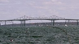
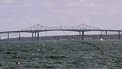
In 1969, the Newport (Pell) Bridge
Claiborne Pell Newport Bridge
The Claiborne Pell Bridge, commonly known as the Newport Bridge, is a suspension bridge operated by the Rhode Island Turnpike and Bridge Authority that spans the East Passage of the Narragansett Bay in Rhode Island , connecting the City of Newport on Aquidneck Island and the Town of Jamestown on...
was completed, establishing Route 138
Route 138 (Rhode Island)
Route 138 is a numbered State Highway running in Rhode Island. It runs from the Connecticut state line to the Massachusetts state line and is the only state-numbered route that traverses the entire state.-Route description:...
as a continuous highway from South County to Newport. With its completion, traditional ferry service was eliminated. (The bridge is celebrated on the Rhode Island commemorative quarters.)
In 1992, the Jamestown-Verrazano Bridge
Jamestown Bridge
The Jamestown Bridge, usually referred to as the Old Jamestown Bridge to avoid confusion with its replacement, the new Jamestown Verrazzano Bridge, was a cantilever truss bridge that connected Conanicut Island to mainland North Kingstown, Rhode Island, spanning the West passage of Narragansett Bay...
replaced the narrow steel bridge erected in 1940. It was accompanied by construction of a new western-end access road and a cross-Conanicut Island highway.
Portions of the films Me, Myself and Irene
Me, Myself and Irene
Me, Myself & Irene is a 2000 American comedy film directed by the Farrelly Brothers, and starring Jim Carrey and Renée Zellweger. Chris Cooper, Robert Forster, Richard Jenkins, Daniel Greene, Anthony Anderson, Jerod Mixon, and Mongo Brownlee co-star...
, American General, Evening
Evening (film)
Evening is a 2007 German-American drama film directed by Lajos Koltai. The screenplay by Susan Minot and Michael Cunningham is based on the 1998 novel of the same name by Susan Minot.-Plot:...
, Dan in Real Life
Dan in Real Life
Dan in Real Life is a 2007 American comedy-drama film directed by Peter Hedges, starring Steve Carell and Juliette Binoche.-Plot:Dan Burns is a newspaper advice columnist, a widower, and a controlling father to his children Jane, Cara and Lilly in the New Jersey suburbs. His column is in...
and Moonrise Kingdom
Moonrise Kingdom
Moonrise Kingdom is an upcoming 2012 film directed by Wes Anderson, written by Anderson and Roman Coppola and starring Bruce Willis alongside Bill Murray and an ensemble cast. Filming took place in Rhode Island from May until June 28, 2011...
were filmed in Jamestown, as well as in various nearby Aquidneck Island towns, such as Middletown and Newport.
Geography
United States Census Bureau
The United States Census Bureau is the government agency that is responsible for the United States Census. It also gathers other national demographic and economic data...
, the town has a total area of 35.3 square miles (91.4 km²), of which, 9.7 square miles (25.1 km²) of it is land and 25.6 square miles (66.3 km²) of it is water. The total area is 72.55% water.
Demographics
As of the censusCensus
A census is the procedure of systematically acquiring and recording information about the members of a given population. It is a regularly occurring and official count of a particular population. The term is used mostly in connection with national population and housing censuses; other common...
of 2000, there are 5,622 people, 2,359 households, and 1,625 families residing in the town. The population density
Population density
Population density is a measurement of population per unit area or unit volume. It is frequently applied to living organisms, and particularly to humans...
is 580.0 people per square mile (224.0/km²). There are 2,769 housing units at an average density of 285.7 per square mile (110.3/km²). The racial makeup of the town is 97.55% White, 0.78% African American, 0.21% Native American, 0.39% Asian, 0.00% Pacific Islander, 0.23% from other races, and 0.84% from two or more races. 0.89% of the population are Hispanic or Latino of any race.
There are 2,359 households out of which 28.3% have children under the age of 18 living with them, 58.5% are married couples
Marriage
Marriage is a social union or legal contract between people that creates kinship. It is an institution in which interpersonal relationships, usually intimate and sexual, are acknowledged in a variety of ways, depending on the culture or subculture in which it is found...
living together, 8.0% have a female householder with no husband present, and 31.1% are non-families. 25.9% of all households are made up of individuals and 9.9% have someone living alone who was 65 years of age or older. The average household size is 2.38 and the average family size is 2.88.
In the town, the population is spread out with 22.0% under the age of 18, 4.3% from 18 to 24, 25.4% from 25 to 44, 33.5% from 45 to 64, and 14.7% who are 65 years of age or older. The median age is 44 years. For every 100 females, there are 94.6 males, and for every 100 females age 18 and over, there are 91.6 males.
The median income for a household in the town is $63,073, and the median income for a family is $77,990. Males have a median income of $50,185 versus $35,056 for females. The per capita income
Per capita income
Per capita income or income per person is a measure of mean income within an economic aggregate, such as a country or city. It is calculated by taking a measure of all sources of income in the aggregate and dividing it by the total population...
for the town is $38,664. 2.9% of the population and 1.7% of families are below the poverty line. 1.4% of those under the age of 18 and 3.1% of those 65 and older are living below the poverty line.
Geological History
All of Rhode Island was part of a volcanic arc or micro-continent called AvaloniaAvalonia
Avalonia was a microcontinent in the Paleozoic era. Crustal fragments of this former microcontinent underlie south-west Great Britain, and the eastern coast of North America. It is the source of many of the older rocks of Western Europe, Atlantic Canada, and parts of the coastal United States...
, which formed south of the equator more than 565 million years ago.
Avalonia drifted northward; eventually colliding with Proto North America about 400 million years ago. The impact contributed most of the land that has become the New England states and created most of the northern Appalachians.
About 350 million years ago, North America and North Africa collided as part of the formation of a supercontinent, Pangaea. For more than 100 million years, Jamestown was located deep within the supercontinent. The layers of shale and coal that are common in the Narraganset Bay area were formed during this period. About 200 million years ago, Pangaea broke up, the Atlantic Ocean formed and slowly widened.
During the past 75,000 years, Jamestown was visited by glaciers at least twice. They gouged out channels in the Narragansett Basin and left deposits of rocks and soil throughout the area. The last glaciers left the area about 12,000 years ago. Sea level was hundreds of feet lower than today; but as additional glaciers melted around the world, the sea rose, covering the continental shelf and eventually filling Narragansett Bay.
National Historic Places and notable sites in Jamestown
- Artillery ParkArtillery ParkArtillery Park is an historic cemetery at North Road and Narragansett Avenue in Jamestown, Rhode Island.Artillery Park has served as a burial ground since the 17th century.-References and external links:**...
- Beavertail Light
- Thomas Carr Farmstead Site (Keeler Site RI-707)Thomas Carr Farmstead Site (Keeler Site RI-707)The Thomas Carr Farmstead Site is a historic archaeological site in Jamestown, Rhode Island on Route 707.Thomas Carr built a homestead on the site in the early 18th century and the site added to the National Register of Historic Places in 1984 as building #84000356.-References:...
- Conanicut BatteryConanicut BatteryConanicut Battery is a colonial and 20th century military battery in Jamestown, Rhode Island, west of Beaver Tail Road.During the American revolution, the British occupied and rebuilt the colonial battery in 1776. During the early 20th century the U.S. military built large underground defensive...
- Conanicut Island Lighthouse
- Dutch Island Lighthouse
- Fort Dumpling Site
- Friends Meetinghouse (Jamestown, Rhode Island)Friends Meetinghouse (Jamestown, Rhode Island)The Friends Meetinghouse is a historic Quaker meeting house in Jamestown, Rhode Island in the Windmill Hill Historic District.The church was built in 1786 to replace the original meeting house destroyed by the British prior to the Battle of Rhode Island. The building was added to the National...
- Hazard Farmstead (Joyner Site RI-706)Hazard Farmstead (Joyner Site RI-706)The Hazard Farmstead is a historic archaeological site in Jamestown, Rhode Island....
- Horsehead-MarbellaHorsehead-MarbellaHorsehead-Marbella is an historic farm at 240 Highland Drive in Jamestown, Rhode Island.C.L. Bevins and J.D. Johnston built the farmhouse in the late-nineteenth century in an American Shingle style. Joseph Wharton, founder of the Wharton School, lived in the home...
- Jamestown Archeological DistrictJamestown Archeological DistrictJamestown Archeological District is an archaeological site in Jamestown, Rhode Island.The archaeological site has diverse Native American, British, and colonial American archaeological remains. The district was added to the National Historic Register in 1989 as District #83004869.-References and...
- Jamestown WindmillJamestown WindmillThe Jamestown Windmill is a smock mill in Jamestown, Rhode Island within the Windmill Hill Historic District on North Road north of Weeden Lane....
- Old Friends Archeological SiteOld Friends Archeological SiteOld Friends Archeological Site is a Quaker historical site in Jamestown, Rhode Island.Jamestown was home to a sizable Friends community in the eighteenth century and this archaeological site relates to that community. The site was added in 1995 to the National Register of Historic Places....
- Windmill Hill Historic DistrictWindmill Hill Historic DistrictWindmill Hill Historic District is a historic district at Eldred Avenue and North Main Road in Jamestown, Rhode Island.The area contains several Colonial American buildings including the Old Jamestown Windmill which operated from 1787 until 1896 on Windmill Hill. There is also an active Quaker...