
Iowa State Highway 9
Encyclopedia
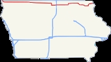
Iowa Highway 9 is the most northern of Iowa
's east–west highways, traversing the entire northern tier of counties. It runs from the eastern terminus of South Dakota Highway 42
at the South Dakota
border east of Sioux Falls, South Dakota
near Benclare
, to the Wisconsin
border at Lansing where it continues as Wisconsin Highway 82. It is largely rural in character, bypassing any large city. Making a few dips north and south, the highway largely follows a very straight east–west alignment.
, northwest of Larchwood
in Lyon County
. It runs south of Lester
, at the northern edge of Rock Rapids
and south of Little Rock
. Crossing into Osceola County
, Iowa Highway 60
crosses it just north and slightly west of Sibley
. Continuing west, is runs to the north of Ocheyedan
. Entering Dickinson County
, the highway passes south of Silver Lake and then across the Little Sioux River
, into Spirit Lake
where it briefly joins U.S. Route 71
. It dips southeasterly as it enters Emmet County
, continuing into
Estherville
where it crosses Iowa Highway 4 and a tributary of the Des Moines River
. Passing just south of Armstrong
it has an intersection with Iowa Highway 15.
In Kossuth County
, it passes through Swea City
. East of Swea City, it is joined by U.S. Route 169
. It passes north of Lakota
, where US 169 turns north. Travelling through Buffalo Center
in Winnebago County
, takes a slight southwesterly dip to pass northeast of Thompson
, continues east, and then south to join U.S. Route 69
at the northern edge of Forest City
where it again turns east.
In Worth County
, it travels past the northern edges of Fertile
and Hanlontown
, where it soon crosses Interstate 35
. West of I-35, it passes through the south side of Manly
.
In Mitchell County
, it makes a straight run to and through Osage
. It swings back north and resumes going west to Riceville
, crossing the Wapsipinicon River
in the process.
In Howard County
, the highway makes a transition into the Driftless Area of Iowa, with progressively more rugged terrain evident as one travels east. West of Cresco
, and south of Lime Springs
, it crosses U.S. Route 63
before going through Cresco. In the process, it crosses two tributaries of the Turkey River
.
In Winneshiek County
, it runs southeasterly, straightening out to go through Decorah
in the valley of the Upper Iowa River
. In Decorah, it crosses U.S. Route 52
. It again takes a southeasterly drift. In Allamakee County
, the highway becomes crooked. Just east of the county line, Iowa Highway 51
meets its northern terminus. Running south of Waukon
, then turns north through Waukon, briefly joined by Iowa Highway 76
. In the northern part of Waukon, it curves north and east, into Lansing
, through the valley of Clear Creek
and downtown Lansing. Just before crossing the Mississippi River
, it meets the southern terminus of Iowa Highway 26
. It then turns onto the Black Hawk Bridge
, where it joins Wisconsin Highway 82.
Iowa
Iowa is a state located in the Midwestern United States, an area often referred to as the "American Heartland". It derives its name from the Ioway people, one of the many American Indian tribes that occupied the state at the time of European exploration. Iowa was a part of the French colony of New...
's east–west highways, traversing the entire northern tier of counties. It runs from the eastern terminus of South Dakota Highway 42
South Dakota Highway 42
South Dakota Highway 42 travels from Ethan, SD to Rowena, SD , then turning to Iowa State Highway 9 in Iowa.Highway 42 travels through Sioux Falls, where it is known as 12th Street from the western city limits to Menlo Avenue. At Menlo Avenue, Highway 42 curves north slightly and becomes 11th...
at the South Dakota
South Dakota
South Dakota is a state located in the Midwestern region of the United States. It is named after the Lakota and Dakota Sioux American Indian tribes. Once a part of Dakota Territory, South Dakota became a state on November 2, 1889. The state has an area of and an estimated population of just over...
border east of Sioux Falls, South Dakota
Sioux Falls, South Dakota
Sioux Falls is the largest city in the U.S. state of South Dakota. Sioux Falls is the county seat of Minnehaha County, and also extends into Lincoln County to the south...
near Benclare
Benclare, South Dakota
Benclare is an unincorporated community in the extreme southeastern corner of Minnehaha County, South Dakota, United States.-Geography:Benclare is located at . Benclare sits 1½ miles west of the Minnesota border and ½ mile north of the border with Iowa...
, to the Wisconsin
Wisconsin
Wisconsin is a U.S. state located in the north-central United States and is part of the Midwest. It is bordered by Minnesota to the west, Iowa to the southwest, Illinois to the south, Lake Michigan to the east, Michigan to the northeast, and Lake Superior to the north. Wisconsin's capital is...
border at Lansing where it continues as Wisconsin Highway 82. It is largely rural in character, bypassing any large city. Making a few dips north and south, the highway largely follows a very straight east–west alignment.
Route description
Iowa Highway 9 enters from South Dakota as a continuation of South Dakota Highway 42South Dakota Highway 42
South Dakota Highway 42 travels from Ethan, SD to Rowena, SD , then turning to Iowa State Highway 9 in Iowa.Highway 42 travels through Sioux Falls, where it is known as 12th Street from the western city limits to Menlo Avenue. At Menlo Avenue, Highway 42 curves north slightly and becomes 11th...
, northwest of Larchwood
Larchwood, Iowa
Larchwood is a city in Lyon County, Iowa, United States. The population was 788 at the 2000 census. Its main employer is the Novartis Animal Vaccines plant located southwest of the city.-History:...
in Lyon County
Lyon County, Iowa
-2010 census:The 2010 census recorded a population of 11,581 in the county, with a population density of . There were 4,848 housing units, of which 4,442 were occupied.-2000 census:...
. It runs south of Lester
Lester, Iowa
Lester is a city in Lyon County, Iowa, United States. The population was 251 at the 2000 census.-Geography:Lester's longitude and latitude coordinatesin decimal form are 43.437475, -96.333322...
, at the northern edge of Rock Rapids
Rock Rapids, Iowa
Rock Rapids is a city in Lyon County in the northwestern part of the U.S. state of Iowa, an area known for its strong Dutch heritage and conservative politics. It is the county seat of Lyon County and home to Central Lyon Schools. The population was 2,549 in the 2010 census, a decline from 2,573...
and south of Little Rock
Little Rock, Iowa
Little Rock is a city in Lyon County, Iowa, United States, along the Little Rock River. The population was 489 at the 2000 census.-Geography:Little Rock is located at ....
. Crossing into Osceola County
Osceola County, Iowa
Osceola County is a county located in the U.S. state of Iowa. It is named for Seminole war chief Osceola. The population was 6,462 in the 2010 census, a decline from 7,003 in the 2000 census. The county seat is Sibley, named for H. H. Sibley of Minnesota....
, Iowa Highway 60
Iowa Highway 60
Iowa Highway 60 is a north–south state highway in northwest Iowa. The highway runs at a southwest-to-northeast angle. The southern end of Iowa Highway 60 is near Le Mars at a freeway interchange with U.S. Route 75 and U.S. Route 75 Business...
crosses it just north and slightly west of Sibley
Sibley, Iowa
Sibley is a city in Osceola County, Iowa, United States. The population was 2,796 at the 2000 census. It is the county seat of Osceola County. It is named after Henry Hastings Sibley, a prominent General during the Dakota War of 1862, who eventually became the first territorial governor of...
. Continuing west, is runs to the north of Ocheyedan
Ocheyedan, Iowa
Ocheyedan is a city in Osceola County, Iowa, United States. The population was 536 at the 2000 census.-Geography:Ocheyedan is located at .According to the United States Census Bureau, the city has a total area of , all of it land....
. Entering Dickinson County
Dickinson County, Iowa
-2010 census:The 2010 census recorded a population of 16,667 in the county, with a population density of . There were 12,849 housing units, of which 7,554 were occupied.-2000 census:...
, the highway passes south of Silver Lake and then across the Little Sioux River
Little Sioux River
The Little Sioux is a river in the United States. It rises in southwest Minnesota near the Iowa border, and continues to flow southwest for across northwest Iowa into the Missouri River at Little Sioux. The Little Sioux River was known as Eaneah-waudepon or "Stone River" to the Sioux Indians...
, into Spirit Lake
Spirit Lake, Iowa
Spirit Lake is a city in Dickinson County, Iowa, United States. The population was 4,261 at the 2000 census. It is the county seat of Dickinson County.The town is located along the western shore of East Okoboji Lake, in the Iowa Great Lakes region....
where it briefly joins U.S. Route 71
U.S. Route 71
U.S. Route 71 is a north–south United States highway. This original 1926 route has remained largely unchanged by encroaching Interstate highways. Currently, the highway's northern terminus is in International Falls, Minnesota at the Canadian border, at the southern end of the Fort...
. It dips southeasterly as it enters Emmet County
Emmet County, Iowa
-2010 census:The 2010 census recorded a population of 10,302 in the county, with a population density of . There were 4,758 housing units, of which 4,236 were occupied.-2000 census:...
, continuing into
Estherville
Estherville, Iowa
Estherville is a city in Emmet County, Iowa, United States. The population was 6,360 in the 2010 census, a decline from 6,656 in the 2000 census. It is the county seat of Emmet County. Estherville is home to the main campus of Iowa Lakes Community College...
where it crosses Iowa Highway 4 and a tributary of the Des Moines River
Des Moines River
The Des Moines River is a tributary river of the Mississippi River, approximately long to its farther headwaters, in the upper Midwestern United States...
. Passing just south of Armstrong
Armstrong, Iowa
Armstrong is a city in Emmet County, Iowa, United States. The population was 979 at the 2000 census. It was originally known as Armstrong Grove.-Geography:Armstrong is located at ....
it has an intersection with Iowa Highway 15.
In Kossuth County
Kossuth County, Iowa
-2010 census:The 2010 census recorded a population of 15,543 in the county, with a population density of . There were 7,486 housing units, of which 6,697 were occupied.-2000 census:...
, it passes through Swea City
Swea City, Iowa
Swea City is a city in Kossuth County, Iowa, United States. The population was 642 at the 2000 census.-History:In February 1893, the town of Reynolds became known as Swea City. Swea City was petitioned for incorporation on December 11, 1894 with a population of 161...
. East of Swea City, it is joined by U.S. Route 169
U.S. Route 169
U.S. Route 169 currently runs for 966 miles from the city of Virginia, Minnesota to Tulsa, Oklahoma at U.S. Route 64.-Oklahoma:U.S. Highway 169 is a major south–north highway spanning in Oklahoma. The southern terminus for US-169 is Memorial Drive...
. It passes north of Lakota
Lakota, Iowa
Lakota is a city in Kossuth County, Iowa, United States. The population was 255 at the 2000 census. Prior to 1920, the town was known as Germania.-Geography:Lakota is located at ....
, where US 169 turns north. Travelling through Buffalo Center
Buffalo Center, Iowa
Buffalo Center is a city in Winnebago County, Iowa, United States. The population was 963 at the 2000 census. Its ZIP code is 50424.-Geography:Buffalo Center is located at ....
in Winnebago County
Winnebago County, Iowa
-2010 census:The 2010 census recorded a population of 10,866 in the county, with a population density of . There were 5,194 housing units, of which 4,597 were occupied.-2000 census:...
, takes a slight southwesterly dip to pass northeast of Thompson
Thompson, Iowa
Thompson is a city in Winnebago County, Iowa, United States. The population was 596 at the 2000 census.-Geography:Thompson is located at .According to the United States Census Bureau, the city has a total area of , all of it land....
, continues east, and then south to join U.S. Route 69
U.S. Route 69
U.S. Route 69 is a north–south United States highway. When it was first created, it was only long, but it has since been expanded into a Minnesota to Texas cross-country route. The highway's southern terminus is in Port Arthur, Texas at an intersection with State Highway 87...
at the northern edge of Forest City
Forest City, Iowa
Forest City is a city in Hancock and Winnebago Counties in the U.S. state of Iowa, and the county seat of Winnebago County. The population was 4,151 in the 2010 census, a decline from the 4,362 population in the 2000 census....
where it again turns east.
In Worth County
Worth County, Iowa
-2010 census:The 2010 census recorded a population of 7,598 in the county, with a population density of . There were 3,548 housing units, of which 3,172 were occupied.-2000 census:...
, it travels past the northern edges of Fertile
Fertile, Iowa
Fertile is a city in Worth County, Iowa, United States. The population was 360 at the 2000 census. It is part of the Mason City Micropolitan Statistical Area.-Geography:Fertile is located at ....
and Hanlontown
Hanlontown, Iowa
Hanlontown is a city in Worth County, Iowa, United States. The population was 229 at the 2000 census. It is part of the Mason City Micropolitan Statistical Area.-Geography:Hanlontown is located at ....
, where it soon crosses Interstate 35
Interstate 35
Interstate 35 is a north–south Interstate Highway in the central United States. I-35 stretches from Laredo, Texas, on the U.S.-Mexico border to Duluth, Minnesota, at Minnesota Highway 61 and 26th Avenue East. Many interstates used to have splits or spurs indicated with suffixed letters , but I-35...
. West of I-35, it passes through the south side of Manly
Manly, Iowa
Manly is a city in Worth County, Iowa, United States. The population was 1,342 at the 2000 census. It is part of the Mason City Micropolitan Statistical Area.-Geography:Manly is located at ....
.
In Mitchell County
Mitchell County, Iowa
-2010 census:The 2010 census recorded a population of 10,776 in the county, with a population density of . There were 4,850 housing units, of which 4,395 were occupied.-2000 census:According to the U.S...
, it makes a straight run to and through Osage
Osage, Iowa
Osage is a city in Mitchell County, Iowa, United States. The population was 3,451 at the 2000 census. It is the county seat of Mitchell County.-Geography:Osage is located at ....
. It swings back north and resumes going west to Riceville
Riceville, Iowa
Riceville is a city in Howard and Mitchell Counties in the U.S. state of Iowa. The population was 840 at the 2000 census.-Geography:Riceville is located at ....
, crossing the Wapsipinicon River
Wapsipinicon River
The Wapsipinicon River is a tributary of the Mississippi River, approximately long, in northeastern Iowa in the United States. It drains a rural farming region of rolling hills and bluffs north of Waterloo and Cedar Rapids. The initial vowel rhymes with "pop".It rises in Mower County, Minnesota...
in the process.
In Howard County
Howard County, Iowa
-2010 census:The 2010 census recorded a population of 9,566 in the county, with a population density of . There were 4,367 housing units, of which 3,944 were occupied.-2000 census:...
, the highway makes a transition into the Driftless Area of Iowa, with progressively more rugged terrain evident as one travels east. West of Cresco
Cresco, Iowa
As of the census of 2000, there were 3,905 people, 1,652 households, and 1,004 families residing in the city. The population density was 1,184.1 people per square mile . There were 1,791 housing units at an average density of 543.1 per square mile...
, and south of Lime Springs
Lime Springs, Iowa
Lime Springs is a city in Howard County, Iowa, United States. The population was 496 at the 2000 census.-Geography:Lime Springs is located at...
, it crosses U.S. Route 63
U.S. Route 63
U.S. Route 63 is a long north–south United States highway primarily in the Midwestern United States. The southern terminus of the route is at Interstate 20 in Ruston, Louisiana. The northern terminus is at U.S. Route 2 in Benoit, Wisconsin, about east of Duluth, Minnesota. It is not related to U.S...
before going through Cresco. In the process, it crosses two tributaries of the Turkey River
Turkey River (Iowa)
The Turkey River is a tributary of the upper Mississippi River. Its main branch rises in Howard County, Iowa, near the city of Cresco. The other counties it or its tributaries cover are Chickasaw, Winneshiek, Fayette, Clayton, Delaware, and Dubuque....
.
In Winneshiek County
Winneshiek County, Iowa
-2010 census:The 2010 census recorded a population of 21,056 in the county, with a population density of . There were 8,721 housing units, of which 7,997 were occupied.-2000 census:...
, it runs southeasterly, straightening out to go through Decorah
Decorah, Iowa
Decorah is a city in and the county seat of Winneshiek County, Iowa, United States. The population was 8,172 at the 2000 census. Decorah is located at the intersection of State Highway 9 and U.S...
in the valley of the Upper Iowa River
Upper Iowa River
The Upper Iowa River is a tributary of the Mississippi River in the upper Midwest of the United States.Its headwaters are in southeastern Minnesota, in Mower County near the border with Iowa. It then flows through the Iowa counties of Howard, Winneshiek, and Allamakee, and finally into the Upper...
. In Decorah, it crosses U.S. Route 52
U.S. Route 52
U.S. Route 52 is a United States highway that runs across the northern, eastern and southeastern regions of the United States. Contrary to most other even-numbered U.S...
. It again takes a southeasterly drift. In Allamakee County
Allamakee County, Iowa
-2010 census:The 2010 census recorded a population of 14,330 in the county, with a population density of . There were 7,617 housing units, of which 5,845 were occupied.-2000 census:...
, the highway becomes crooked. Just east of the county line, Iowa Highway 51
Iowa Highway 51
Iowa Highway 51 is a state highway that runs from north to south in northeast Iowa. Contained entirely by Allamakee County, it is only in length. Its southern terminus is at U.S. Highway 52 and U.S. Highway 18 in Postville. Its northern terminus is at Iowa Highway 9 near Waukon.-Route...
meets its northern terminus. Running south of Waukon
Waukon, Iowa
Waukon is a city in Makee Township,Allamakee County, Iowa, United States, and the county seat of Allamakee County. The population was 4,131 at the 2000 census. It is home to the annual .-History:...
, then turns north through Waukon, briefly joined by Iowa Highway 76
Iowa Highway 76
Iowa Highway 76 is a state highway located in northeastern Iowa, most of which is in Allamakee County. The long highway connects McGregor to Eitzen, Minnesota via Waukon. It begins in McGregor at an intersection with U.S. Route 18; the first of the route are signed as U.S. Route 18 Business...
. In the northern part of Waukon, it curves north and east, into Lansing
Lansing, Iowa
Lansing is a city in Lansing Township, Allamakee County, Iowa, United States. The population was 1,012 at the 2000 census.-Geography:Lansing's longitude and latitude coordinatesin decimal form are 43.361525, -91.223378...
, through the valley of Clear Creek
Clear Creek (Iowa)
Clear Creek is a minor tributary of the Upper Mississippi River entirely contained within Allamakee County, Iowa. It enters the Mississippi into Navigation Pool 9 through the city of Lansing, Iowa. Iowa Highway 9 runs through its canyon. It has been restored as fishing stream for brown trout. The...
and downtown Lansing. Just before crossing the Mississippi River
Upper Mississippi River
The Upper Mississippi River is the portion of the Mississippi River upstream of Cairo, Illinois, United States. From the headwaters at Lake Itasca, Minnesota, the river flows approximately 2000 kilometers to Cairo, where it is joined by the Ohio River to form the Lower Mississippi...
, it meets the southern terminus of Iowa Highway 26
Iowa Highway 26
Iowa Highway 26 is a long state highway that runs from south to north in Allamakee County, Iowa. It begins in Lansing at an intersection with Iowa Highway 9 at the Black Hawk Bridge and ends at the Minnesota border at New Albin. It continues into Minnesota as Minnesota State Highway 26 . Iowa...
. It then turns onto the Black Hawk Bridge
Black Hawk Bridge
The Black Hawk Bridge spans the Mississippi River, joining the town of Lansing, in Allamakee County, Iowa, to rural Crawford County, Wisconsin. It is the northernmost Mississippi River bridge in Iowa....
, where it joins Wisconsin Highway 82.