
Indiana State Road 16
Encyclopedia
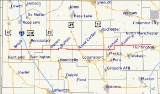
State Road 16 is an east–west road in Northern Indiana
. Its western terminus is at U.S. Route 41
in Ade, Indiana
. Its eastern terminus is at State Road 5
north of Huntington, Indiana
.
. SR 16 passes through Brook
and Monon
where SR 16 meets U.S. Route 421
. After Monon SR 16 passes through Buffalo
, Royal Center
, and Denver
. After Denver SR 16 turns due north onto State Road 19
, after 3 miles (4.8 km) SR 16 turns due east. Then SR 16 eastern terminus is at SR 5 north of Huntington.
to New Albany
. Following the route that State Road 62
does today. Between 1926 and 1934 SR 16 went to the Ohio
State Line. In 1934 U.S. Route 224
was commissioned in Indiana and was route onto SR 16 from Huntington to the Ohio State Line.
Northern Indiana
Northern Indiana is the region of Indiana including 26 counties bordering parts of Illinois, Michigan, and Ohio. The area is generally sub-classified into other regions. The northwest is economically and culturally intertwined with Chicago, and is considered part of the Chicago metropolitan area...
. Its western terminus is at U.S. Route 41
U.S. Route 41 in Indiana
In the U.S. state of Indiana, U.S. Route 41 is a north–south highway that is parallel to the Illinois state line. It enters the state south of Evansville. North of Evansville, it becomes a 4-Lane divided highway passing around Vincennes and traveling North to Terre Haute. In Terre Haute, it...
in Ade, Indiana
Ade, Indiana
Ade is an unincorporated town in Washington Township, Newton County, Indiana....
. Its eastern terminus is at State Road 5
Indiana State Road 5
State Road 5 is a north–south road that runs through northeast Indiana. Its southern terminus is at SR 22 in Upland, and the northern terminus is at SR 120 just north of Shipshewana. The largest city along its path is Huntington...
north of Huntington, Indiana
Huntington, Indiana
Huntington, known as the "Lime City", is a small city in and the county seat of Huntington County, Indiana, United States. It is in Huntington Township and Union Township...
.
Route description
SR 16 begins at US 41 in Ade, then SR 16 heads due east toward HuntingtonHuntington, Indiana
Huntington, known as the "Lime City", is a small city in and the county seat of Huntington County, Indiana, United States. It is in Huntington Township and Union Township...
. SR 16 passes through Brook
Brook, Indiana
Brook is a town located in Iroquois Township, Newton County, Indiana. As of the 2010 census, the town had a total population of 997.-Geography:Brook is located at 40°51'58" North, 87°21'57" West ....
and Monon
Monon, Indiana
Monon is a town in Monon Township,White County, Indiana, United States. The population was 1,777 at the 2010 census.-Geography:According to the United States Census Bureau, the town has a total area of , all of it land.-Demographics:...
where SR 16 meets U.S. Route 421
U.S. Route 421
U.S. Route 421 is a spur route of U.S. 21. It runs for from Michigan City, Indiana, at U.S. 20, to Fort Fisher in North Carolina. The highway goes through the cities of Indianapolis, Indiana, Lexington, Kentucky, Boone, North Carolina, Winston-Salem, North Carolina, Greensboro, North Carolina and...
. After Monon SR 16 passes through Buffalo
Buffalo, Indiana
Buffalo is a census-designated place in White County, Indiana, United States. The population was 672 at the 2000 census.-Geography:Buffalo is located at ....
, Royal Center
Royal Center, Indiana
Royal Center is a town in Boone Township, Cass County, Indiana, United States. The population was 832 at the 2000 census.-Geography:Royal Center is located at ....
, and Denver
Denver, Indiana
Denver is a town in Jefferson Township, Miami County, Indiana, United States. The population was 541 at the 2000 census.-Geography:Denver is located at ....
. After Denver SR 16 turns due north onto State Road 19
Indiana State Road 19
State Road 19 in the U.S. state of Indiana begins at State Road 32 in Noblesville in the south, and runs north to the Michigan state line just north of Elkhart, a distance of...
, after 3 miles (4.8 km) SR 16 turns due east. Then SR 16 eastern terminus is at SR 5 north of Huntington.
History
Between 1917 and 1926, SR 16 was in southern Indiana going from Mt. VernonMount Vernon, Indiana
Mount Vernon is a city in southern Indiana along the Ohio River and the county seat of Posey County. It is located in Black Township. As of the 2010 census, the city's population was 6,687...
to New Albany
New Albany, Indiana
New Albany is a city in Floyd County, Indiana, United States, situated along the Ohio River opposite Louisville, Kentucky. In 1900, 20,628 people lived in New Albany; in 1910, 20,629; in 1920, 22,992; and in 1940, 25,414. The population was 36,372 at the 2010 census. The city is the county seat of...
. Following the route that State Road 62
Indiana State Road 62
State Road 62 in the U.S. State of Indiana is an east–west route that runs from the Illinois state line in the southwest corner of Indiana to the Louisville, Kentucky area, then northeast toward the Cincinnati, Ohio area.-Route description:...
does today. Between 1926 and 1934 SR 16 went to the Ohio
Ohio
Ohio is a Midwestern state in the United States. The 34th largest state by area in the U.S.,it is the 7th‑most populous with over 11.5 million residents, containing several major American cities and seven metropolitan areas with populations of 500,000 or more.The state's capital is Columbus...
State Line. In 1934 U.S. Route 224
U.S. Route 224 in Indiana
U.S. Route 224 is a part of the United States Numbered Highway that runs from Huntington, Indiana to New Castle, Pennsylvania. In Indiana, it is a rural, two-lane route that travels in the northern part of the state. The western terminus is at U.S. Route 24, State Road 5, and State Road 9...
was commissioned in Indiana and was route onto SR 16 from Huntington to the Ohio State Line.