
Indiana State Road 103
Encyclopedia
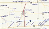
State Road 103 in the U.S. State
of Indiana
is a 14 miles (22.5 km) north–south route in Henry County
.
, between U.S. Route 36
east of Mount Summit
and U.S. Route 40
in Lewisville
. It runs through downtown New Castle
and past the Wilbur Wright Fish and Wildlife Area. It also crosses Interstate 70
, but there is no interchange.
U.S. state
A U.S. state is any one of the 50 federated states of the United States of America that share sovereignty with the federal government. Because of this shared sovereignty, an American is a citizen both of the federal entity and of his or her state of domicile. Four states use the official title of...
of Indiana
Indiana
Indiana is a US state, admitted to the United States as the 19th on December 11, 1816. It is located in the Midwestern United States and Great Lakes Region. With 6,483,802 residents, the state is ranked 15th in population and 16th in population density. Indiana is ranked 38th in land area and is...
is a 14 miles (22.5 km) north–south route in Henry County
Henry County, Indiana
As of the census of 2000, there were 48,508 people, 19,486 households, and 13,971 families residing in the county. The population density was 124 people per square mile . There were 20,592 housing units at an average density of 52 per square mile...
.
Route description
State Road 103 nearly parallels its parent route, State Road 3Indiana State Road 3
State Road 3 in the U.S. State of Indiana is a discontinuous state road running through east central Indiana from near the Michigan state line to near the Ohio River...
, between U.S. Route 36
U.S. Route 36
U.S. Route 36 is an east–west United States highway that runs for from Rocky Mountain National Park, Colorado to Uhrichsville, Ohio. The highway's western terminus is at Deer Ridge Junction, an intersection in Rocky Mountain National Park, Colorado, where it meets U.S. Route 34. Its eastern...
east of Mount Summit
Mount Summit, Indiana
Mount Summit is a town in Prairie Township, Henry County, Indiana, United States. The population was 352 at the 2010 census.-Geography:Mount Summit is located at ....
and U.S. Route 40
U.S. Route 40
U.S. Route 40 is an east–west United States highway. As with most routes whose numbers end in a zero, U.S. 40 once traversed the entire United States. It is one of the original 1920s U.S. Highways, and its first termini were San Francisco, California, and Atlantic City, New Jersey...
in Lewisville
Lewisville, Indiana
Lewisville is a town in Franklin Township, Henry County, Indiana, United States. The population was 366 at the 2010 census.-Geography:Lewisville is located at , along the Flatrock River....
. It runs through downtown New Castle
New Castle, Indiana
As of the census of 2000, there were 17,780 people, 7,462 households, and 4,805 families residing in the city. The population density was 2,987.5 people per square mile . There were 8,042 housing units at an average density of 1,351.3 per square mile...
and past the Wilbur Wright Fish and Wildlife Area. It also crosses Interstate 70
Interstate 70
Interstate 70 is an Interstate Highway in the United States that runs from Interstate 15 near Cove Fort, Utah, to a Park and Ride near Baltimore, Maryland. It was the first Interstate Highway project in the United States. I-70 approximately traces the path of U.S. Route 40 east of the Rocky...
, but there is no interchange.