
Indiana State Road 10
Encyclopedia
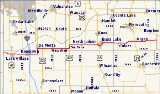
State Road 10 is an east–west road in northwest Indiana. Its western terminus is at the Illinois
state line west of Lake Village
. Its eastern terminus is at State Road 19
(SR 19) south of Etna Green
.
with U.S. Route 41
(US 41). SR 10 then has an interchange
with Interstate 65
(I-65) at exit number 230 on I-65. After I-65, SR 10 has an intersection with State Road 110
and SR 10 heads due north. Then SR 10 turns east onto U.S. Route 231 and both routes go due east until US 231 turns due south on its way to Lafayette
. SR 10 continues due east toward U.S. Route 421
(US 421), passing though Wheatfield where it meets State Road 49
(SR 49). At US 421, SR 10 turns north onto US 421. After a short concurrency with US 421, SR 10 turns east. Then SR 10 meets U.S. Route 35 (US 35); SR 10 and US 35 have a short concurrency heading southeast. Then SR 10 leaves US 35 to the north, northeast, and then east. Near Argos
SR 10 has an intersection with U.S. Route 31 (US 31). After US 31, heads east to its eastern terminus at SR 19.
(US 41). This route was part of the old number system that was in place in Indiana. The current SR 10 route was designated SR 50 from Wheatfield to Argos; the rest was made up of unnumbered roads. Then in 1926, SR 10 changed to its current route.
In the early 1960s, SR 10 was rerouted onto US 35 near Bass Lake
and at that time State Road 210 (SR 210) was decommissioned.
Illinois
Illinois is the fifth-most populous state of the United States of America, and is often noted for being a microcosm of the entire country. With Chicago in the northeast, small industrial cities and great agricultural productivity in central and northern Illinois, and natural resources like coal,...
state line west of Lake Village
Lake Village, Indiana
Lake Village is a census-designated place in Lake Township, Newton County, Indiana, United States. The population was 765 at the 2010 census.-Geography:Lake Village is located at ....
. Its eastern terminus is at State Road 19
Indiana State Road 19
State Road 19 in the U.S. state of Indiana begins at State Road 32 in Noblesville in the south, and runs north to the Michigan state line just north of Elkhart, a distance of...
(SR 19) south of Etna Green
Etna Green, Indiana
Etna Green is a town in Etna Township, Kosciusko County, Indiana, United States. The population was 586 at the 2010 census. Etna Green belongs to Triton School Corporation.-Geography:Etna Green is located at ....
.
Route description
From its western terminus at the Illinois state line, SR 10 heads east; after 3.99 miles (6.4 km) it has an intersectionIntersection (road)
An intersection is a road junction where two or more roads either meet or cross at grade . An intersection may be 3-way - a T junction or fork, 4-way - a crossroads, or 5-way or more...
with U.S. Route 41
U.S. Route 41 in Indiana
In the U.S. state of Indiana, U.S. Route 41 is a north–south highway that is parallel to the Illinois state line. It enters the state south of Evansville. North of Evansville, it becomes a 4-Lane divided highway passing around Vincennes and traveling North to Terre Haute. In Terre Haute, it...
(US 41). SR 10 then has an interchange
Interchange (road)
In the field of road transport, an interchange is a road junction that typically uses grade separation, and one or more ramps, to permit traffic on at least one highway to pass through the junction without directly crossing any other traffic stream. It differs from a standard intersection, at which...
with Interstate 65
Interstate 65 in Indiana
In the U.S. state of Indiana, Interstate 65 traverses the state from south to north. The Indiana portion begins near Louisville, Kentucky and travels north, passing through Columbus, Indianapolis, Lafayette. Interstate 65 terminates near Gary on the Indiana Toll Road. Interstate 65 covers 261.27...
(I-65) at exit number 230 on I-65. After I-65, SR 10 has an intersection with State Road 110
Indiana State Road 110
State Road 110 in Northern Indiana consists of two discontinuous east–west segments. Neither segment passes through any towns.-Route description:The western portion of State Road 110 is long and connects State Road 10 with U.S...
and SR 10 heads due north. Then SR 10 turns east onto U.S. Route 231 and both routes go due east until US 231 turns due south on its way to Lafayette
Lafayette, Indiana
Lafayette is a city in and the county seat of Tippecanoe County, Indiana, United States, northwest of Indianapolis. As of the 2010 census, the city had a total population of 67,140. West Lafayette, on the other side of the Wabash River, is home to Purdue University, which has a large impact on...
. SR 10 continues due east toward U.S. Route 421
U.S. Route 421 in Indiana
U.S. Route 421 enters Indiana from Kentucky, proceeding northwest to Indianapolis, joining Interstate 465, then continuing northwest to Michigan City....
(US 421), passing though Wheatfield where it meets State Road 49
Indiana State Road 49
State Road 49 in the U.S. State of Indiana is a state highway in northwest Indiana. It runs from just north of Chesterton at the intersection with U.S. Route 12 south to a rural interchange 10 miles northeast of Rensselaer with State Road 14...
(SR 49). At US 421, SR 10 turns north onto US 421. After a short concurrency with US 421, SR 10 turns east. Then SR 10 meets U.S. Route 35 (US 35); SR 10 and US 35 have a short concurrency heading southeast. Then SR 10 leaves US 35 to the north, northeast, and then east. Near Argos
Argos, Indiana
Argos is a town in Green and Walnut townships, Marshall County, Indiana, United States. The population was 1,691 at the 2010 census.-Geography:Argos is located at ....
SR 10 has an intersection with U.S. Route 31 (US 31). After US 31, heads east to its eastern terminus at SR 19.
History
From 1918 to 1926, SR 10 followed a portion of the route of the modern U.S. Route 41U.S. Route 41 in Indiana
In the U.S. state of Indiana, U.S. Route 41 is a north–south highway that is parallel to the Illinois state line. It enters the state south of Evansville. North of Evansville, it becomes a 4-Lane divided highway passing around Vincennes and traveling North to Terre Haute. In Terre Haute, it...
(US 41). This route was part of the old number system that was in place in Indiana. The current SR 10 route was designated SR 50 from Wheatfield to Argos; the rest was made up of unnumbered roads. Then in 1926, SR 10 changed to its current route.
In the early 1960s, SR 10 was rerouted onto US 35 near Bass Lake
Bass Lake, Indiana
Bass Lake is a census-designated place in California and North Bend Townships, Starke County, Indiana, United States. The population was 1,249 at the 2000 census...
and at that time State Road 210 (SR 210) was decommissioned.