
Immatain
Encyclopedia
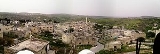
Immatain is a Palestinian
village located in the Qalqilya Governorate
in the northwestern West Bank
, about seventeen kilometers southwest of Nablus
. The current mayor of Immatain is Haythem Sawan. The village's nickname is the "olive orchard".
, Immatain had a population of approximately 2,450 inhabitants in mid-year 2006. Almost double the amount live abroad for political and economical reasons. Each year an average of two family units immigrate from Immatain. Immatain has four families. They are Sawan, Ghanim, Albaree, and Matanee.
and support from descendants who reside abroad. The nearest locality is the village of Fara'ata
, which is about one kilometer away. Immatain and the surrounding villages make Amra Area. These villages are: Fara'ata, Jit
, Kafr Qaddum
, Baqat al-Hatab
, Hajja, Jinsafut
and al-Fanduq.
Caliph
, Umar bin al-Khattab
more than 1400 years ago.
People of Immatain and the surrounidng villages are very proud mountain people. Local history tells that those mountain people defeated Napolion armies in May 1797 when the French army
was on its way to occupy Acca
in Palestine
. The fleeing French army called that area the mountain of Fire. This name for that area is still being in use. The French army eventually made it to Acca and was defeated on its wall.
Palestinian territories
The Palestinian territories comprise the West Bank and the Gaza Strip. Since the Palestinian Declaration of Independence in 1988, the region is today recognized by three-quarters of the world's countries as the State of Palestine or simply Palestine, although this status is not recognized by the...
village located in the Qalqilya Governorate
Qalqilya Governorate
The Qalqilya Governorate is an administrative area of the Palestinian National Authority in the northwestern West Bank. Its capital or muhfaza is the city of Qalqilya that borders the Green Line.-Towns and villages:* Azzun 'Atma* Baqah...
in the northwestern West Bank
West Bank
The West Bank ) of the Jordan River is the landlocked geographical eastern part of the Palestinian territories located in Western Asia. To the west, north, and south, the West Bank shares borders with the state of Israel. To the east, across the Jordan River, lies the Hashemite Kingdom of Jordan...
, about seventeen kilometers southwest of Nablus
Nablus
Nablus is a Palestinian city in the northern West Bank, approximately north of Jerusalem, with a population of 126,132. Located in a strategic position between Mount Ebal and Mount Gerizim, it is the capital of the Nablus Governorate and a Palestinian commercial and cultural center.Founded by the...
. The current mayor of Immatain is Haythem Sawan. The village's nickname is the "olive orchard".
Population
According to the Palestinian Central Bureau of StatisticsPalestinian Central Bureau of Statistics
The Palestinian Central Bureau of Statistics is the statistical organization under the umbrella of the Palestinian Cabinet of the Palestinian National Authority....
, Immatain had a population of approximately 2,450 inhabitants in mid-year 2006. Almost double the amount live abroad for political and economical reasons. Each year an average of two family units immigrate from Immatain. Immatain has four families. They are Sawan, Ghanim, Albaree, and Matanee.
| Family name | Population est. | Percent of the population |
|---|---|---|
| Sawan | 1220 | 49.8% |
| Ghanim | 850 | 34.7% |
| Albaree | 255 | 10.4% |
| Matanee | 125 | 5.1% |
Geography
The village's lands are mostly filled with olive trees, forests, and blooming vegetation and is a prime farming location. Immatain relies on agricultureAgriculture
Agriculture is the cultivation of animals, plants, fungi and other life forms for food, fiber, and other products used to sustain life. Agriculture was the key implement in the rise of sedentary human civilization, whereby farming of domesticated species created food surpluses that nurtured the...
and support from descendants who reside abroad. The nearest locality is the village of Fara'ata
Fara'ata
Fara'ata is a Palestinian town in the Qalqilya Governorate in the Western area of the West Bank, located 16 kilometers Southwest of Nablus. According to the Palestinian Central Bureau of Statistics, the village had a population of approximately 657 inhabitants in 2006....
, which is about one kilometer away. Immatain and the surrounding villages make Amra Area. These villages are: Fara'ata, Jit
Jit, Qalqilya
Jit is a Palestinian town in the northern West Bank, located 10 kilometers west of Nablus. According to the Palestinian Central Bureau of Statistics, the village had a population of approximately 2,320 inhabitants in 2006....
, Kafr Qaddum
Kafr Qaddum
Kafr Qaddum is a Palestinian town in the northern West Bank, located 13 kilometers west of Nablus and 17 kilometers east of Qalqilya in the Qalqilya Governorate. Surrounding towns include Jit to the east and Hajjah to the south...
, Baqat al-Hatab
Baqat al-Hatab
Baqat al-Hatab is a Palestinian town in the Qalqilya Governorate in the Western area of the West Bank, located 20 kilometers southwest of Nablus. According to the Palestinian Central Bureau of Statistics, the village had a population of approximately 1,748 inhabitants in 2006....
, Hajja, Jinsafut
Jinsafut
Jinsafut is a Palestinian village in the Qalqilya Governorate in the northeastern West Bank, located fifteen kilometers east of Qalqilya, and sixteen kilometers east of Nablus. It lies at an elevation of around 430 meters above sea level...
and al-Fanduq.
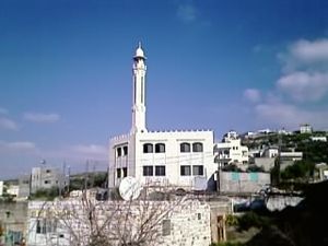
History
Immatain is an ancient village in Palestine. The old mosque is dated back to the rule of the RashidunRashidun
The Rightly Guided Caliphs or The Righteous Caliphs is a term used in Sunni Islam to refer to the first four Caliphs who established the Rashidun Caliphate. The concept of "Rightly Guided Caliphs" originated with the Abbasid Dynasty...
Caliph
Caliph
The Caliph is the head of state in a Caliphate, and the title for the ruler of the Islamic Ummah, an Islamic community ruled by the Shari'ah. It is a transcribed version of the Arabic word which means "successor" or "representative"...
, Umar bin al-Khattab
Umar
`Umar ibn al-Khattāb c. 2 November , was a leading companion and adviser to the Islamic prophet Muhammad who later became the second Muslim Caliph after Muhammad's death....
more than 1400 years ago.
People of Immatain and the surrounidng villages are very proud mountain people. Local history tells that those mountain people defeated Napolion armies in May 1797 when the French army
French Army
The French Army, officially the Armée de Terre , is the land-based and largest component of the French Armed Forces.As of 2010, the army employs 123,100 regulars, 18,350 part-time reservists and 7,700 Legionnaires. All soldiers are professionals, following the suspension of conscription, voted in...
was on its way to occupy Acca
Acca
-ACCA as an abbreviation:ACCA may refer to:In Biology* Acetyl-CoA carboxylaseIn Business:* American Corporate Counsel Association, now Association of Corporate Counsel , is a group for attorneys who practice in the legal departments of corporations, associations and other private-sector...
in Palestine
Palestine
Palestine is a conventional name, among others, used to describe the geographic region between the Mediterranean Sea and the Jordan River, and various adjoining lands....
. The fleeing French army called that area the mountain of Fire. This name for that area is still being in use. The French army eventually made it to Acca and was defeated on its wall.