

Honobia, Oklahoma
Encyclopedia
Honobia is a community
on the border between western LeFlore County, Oklahoma and eastern Pushmataha County, Oklahoma
, 15 miles southeast of Talihina
.
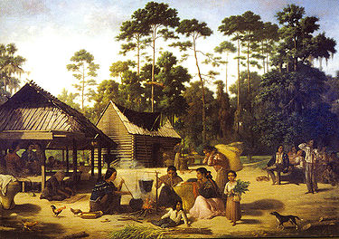 The community is named for O-no-bi-a, Choctaw Indian land allottee. The name of the community is pronounced “Hono-bee”.
Following the Choctaw Indians' relocation to the area over the Trail of Tears
, and the establishment of the Choctaw Nation there, Honobia became home to a Choctaw settlement. Until statehood the area was part of Wade County in the Apukshunnubbee District
of the Choctaw Nation. Although the national capital and its stately Choctaw Capitol Building
were located only 32 miles away, at Tuskahoma
, Honobia was (and remains) isolated.
, near its confluences with Honobia Creek and Rock Creek. The community is located in a particularly picturesque part of the Little River valley. The river at this point is a fast-flowing mountain stream, and its narrow valley is framed by steep mountains on both north and south whose summits reach between 1,600 and 1,800 feet in elevation. The mountains are part of the Kiamichi Mountains
.
Oklahoma State Highway 144 connects Honobia with the rural communities of Fewell
, Nolia
, and Nashoba
on the west -- and with U.S. Highway 271 at Nashoba -- and with the even more sparsely populated Pickens and Battiest areas on the east, and then with U.S. Highway 259.
During recent years the Choctaw Nation
has improved transportation in the Honobia area significantly by constructing a paved, all-weather road over the mountains from U.S. Highway 271 near Albion
south over the steep mountain range to Honobia. Locals refer to this as the "Indian Highway". To accomplish its route the Indian Highway travels in a series of switchbacks up the northern side of the mountains and down again on the southern side, allowing for scenic views and vistas.
Each fall residents promote the Annual Bigfoot Festival and Conference, dedicated to the theory that a super-sized humanoid
lives in the forests surrounding the area. This conference is led by veteran Bigfoot researcher Troy Hudson of Henryetta, Oklahoma. This is one of the only mainstay economical boosts to the Honobia area. Locals appear somewhat tongue-in-cheek regarding the possibility that Bigfoot
exists, even as they cheerfully welcome visitors to the festival
.
More information on Honobia and the Little River
valley may be found in the Pushmataha County Historical Society
.
Community
The term community has two distinct meanings:*a group of interacting people, possibly living in close proximity, and often refers to a group that shares some common values, and is attributed with social cohesion within a shared geographical location, generally in social units larger than a household...
on the border between western LeFlore County, Oklahoma and eastern Pushmataha County, Oklahoma
Pushmataha County, Oklahoma
-Administrative History:* Ca. 1000-1500: Caddoan Mississippian civilization at Spiro Mounds* 1492-1718: Spain* 1718-1763: France* 1763-1800: Spain* 1800-1803: France* 1803–present: United States...
, 15 miles southeast of Talihina
Talihina, Oklahoma
Talihina is a town in Le Flore County, Oklahoma, United States, its name originating from two Choctaw words, tully and hena, meaning iron road. Iron road is reference to the railroad that the town was built around. It is part of the Fort Smith, Arkansas-Oklahoma Metropolitan Statistical Area...
.
History
A United States Post Office was established here on August 30, 1919. Located on the county line of Pushmataha County, the post office has at times operated in Pushmataha County.Following the Choctaw Indians' relocation to the area over the Trail of Tears
Trail of Tears
The Trail of Tears is a name given to the forced relocation and movement of Native American nations from southeastern parts of the United States following the Indian Removal Act of 1830...
, and the establishment of the Choctaw Nation there, Honobia became home to a Choctaw settlement. Until statehood the area was part of Wade County in the Apukshunnubbee District
Apukshunnubbee District
Apukshunnubbee District was one of three administrative super-regions comprising the former Choctaw Nation in the Indian Territory. Also called the Second District, it encompassed the southeastern one-third of the nation....
of the Choctaw Nation. Although the national capital and its stately Choctaw Capitol Building
Choctaw Capitol Building
The Choctaw Capitol Building is a historic site in Pushmataha County, Oklahoma two miles north of Tuskahoma, Oklahoma. The Choctaw National Council House is located here, as well as the Old Town Cemetery of Tuskahoma....
were located only 32 miles away, at Tuskahoma
Tuskahoma, Oklahoma
Tuskahoma is a community in northern Pushmataha County, Oklahoma, four miles east of Clayton, Oklahoma.-History:A United States Post Office was established at Tushka Homma, Indian Territory on February 27, 1884. On October 28, 1891, the spelling changed to Tushkahomma. On December 6, 1910 the...
, Honobia was (and remains) isolated.
Geography
Honobia is located on Little RiverLittle River (Red River)
The Little River is a tributary of the Red River, about long, in southeastern Oklahoma and southwestern Arkansas in the United States. Via the Red, it is part of the watershed of the Mississippi River.-Course:...
, near its confluences with Honobia Creek and Rock Creek. The community is located in a particularly picturesque part of the Little River valley. The river at this point is a fast-flowing mountain stream, and its narrow valley is framed by steep mountains on both north and south whose summits reach between 1,600 and 1,800 feet in elevation. The mountains are part of the Kiamichi Mountains
Kiamichi Mountains
The Kiamichi Mountains are a mountain range in southeastern Oklahoma. A subrange within the larger Ouachita Mountains that extend from Oklahoma to western Arkansas, the Kiamichi Mountains sit within Le Flore, Pushmataha, and McCurtain counties near the towns of Poteau and Albion...
.
Oklahoma State Highway 144 connects Honobia with the rural communities of Fewell
Fewell, Oklahoma
Fewell is a community in eastern Pushmataha County, Oklahoma.A United States Post Office operated here from November 4, 1913 to October 15, 1943. It was named for Benjamin F...
, Nolia
Nolia, Oklahoma
Nolia is a former community in eastern Pushmataha County, Oklahoma, five miles east of Nashoba, Oklahoma.A United States Post Office operated here from October 26, 1912 to December 15, 1920. It was named for Nolia Johnson, wife of Ben F. Johnson , its first postmaster. Nolia was located in the...
, and Nashoba
Nashoba, Oklahoma
Nashoba is a community in Pushmataha County, Oklahoma, 11 miles southeast of Tuskahoma.A United States Post Office opened at Nashoba, Indian Territory on September 13, 1886. The community took its name from Nashoba County, Choctaw Nation. The county took its name from nashoba, the word in the...
on the west -- and with U.S. Highway 271 at Nashoba -- and with the even more sparsely populated Pickens and Battiest areas on the east, and then with U.S. Highway 259.
During recent years the Choctaw Nation
Choctaw Nation of Oklahoma
The Choctaw Nation of Oklahoma is a semi-autonomous Native American homeland comprising twelve tribal districts. The Choctaw Nation maintains a special relationship with both the United States and Oklahoma governments...
has improved transportation in the Honobia area significantly by constructing a paved, all-weather road over the mountains from U.S. Highway 271 near Albion
Albion, Oklahoma
Albion is a town in Pushmataha County, Oklahoma, United States. The population was 143 at the 2000 census.- History :A United States Post Office opened at Albion, Indian Territory on December 6, 1887 and is still in operation....
south over the steep mountain range to Honobia. Locals refer to this as the "Indian Highway". To accomplish its route the Indian Highway travels in a series of switchbacks up the northern side of the mountains and down again on the southern side, allowing for scenic views and vistas.
Economy
Most of the areas to the north and south of Honobia are vast tree plantations owned by timber companies. As such these areas remain wildernesses covering many square miles. Logging provides an important source of jobs for the area.Each fall residents promote the Annual Bigfoot Festival and Conference, dedicated to the theory that a super-sized humanoid
Humanoid
A humanoid is something that has an appearance resembling a human being. The term first appeared in 1912 to refer to fossils which were morphologically similar to, but not identical with, those of the human skeleton. Although this usage was common in the sciences for much of the 20th century, it...
lives in the forests surrounding the area. This conference is led by veteran Bigfoot researcher Troy Hudson of Henryetta, Oklahoma. This is one of the only mainstay economical boosts to the Honobia area. Locals appear somewhat tongue-in-cheek regarding the possibility that Bigfoot
Bigfoot
Bigfoot, also known as sasquatch, is an ape-like cryptid that purportedly inhabits forests, mainly in the Pacific Northwest region of North America. Bigfoot is usually described as a large, hairy, bipedal humanoid...
exists, even as they cheerfully welcome visitors to the festival
Festival
A festival or gala is an event, usually and ordinarily staged by a local community, which centers on and celebrates some unique aspect of that community and the Festival....
.
More information on Honobia and the Little River
Little River (Red River)
The Little River is a tributary of the Red River, about long, in southeastern Oklahoma and southwestern Arkansas in the United States. Via the Red, it is part of the watershed of the Mississippi River.-Course:...
valley may be found in the Pushmataha County Historical Society
Pushmataha County Historical Society
The Pushmataha County Historical Society is a historical society devoted to collecting and preserving the history of Pushmataha County, Oklahoma...
.