
.gif)
Highway 41 (Ontario)
Encyclopedia
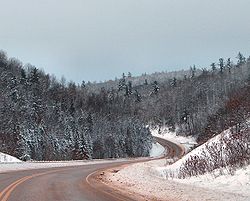
King's Highway 41, commonly referred to as Highway 41, is a provincially maintained highway in the Canadian
province of Ontario
. It travels from Highway 7
in Kaladar
north to Highway 17 on the outskirts of Pembroke
.
, Vennachar Junction, Denbigh, Griffith, Khartum, Eganville
and Rankin.
Highway 41 proceeds through the counties of Lennox/Addington
, Frontenac
, and Renfrew
. Its routing is shared with Highway 60
from Eganville to a point approximately 4 km north of Eganville.
Just over two years later, the route was extended to Highway 60 at Golden Lake. The DHO assumed the portion within Lennox and Addington on October 6, 1937, followed two weeks later by the portion within Renfrew County on October 20. This extended the highway by 125.4 kilometres (77.9 mi).
Both Highway 60 and Highway 41 shared a terminus at a junction in Golden Lake until 1957, when the Eganville to Pembroke Road was designated as Highway 41. The section of highway between Eganville and Golden Lake became an extension of Highway 60.
On January 1, 1998, the section of Highway 41 between Highway 2 in Napanee and Highway 7 in Kaladar was transferred to the county of Lennox and Addington, truncating the highway by 48.9 kilometres (30.4 mi).
{| class="wikitable"
|-
!Division
!Location
!km
!Destinations
!Notes
|-
|rowspan="4"|Lennox and Addington
|bgcolor=#d3d3d3|Greater Napanee
|bgcolor=#d3d3d3|−50.9
|bgcolor=#d3d3d3|
|bgcolor=#d3d3d3|Section decommissioned January 1, 1998
|-
|Kaladar
|0.0
|
|
|-
|Northbrook
|11.3
|
|Beaver Creek Bridge
|-
|rowspan="2"|Cloyne
|18.5
|Hunt Road
|Formerly Highway 506
|-
|rowspan="2"|Frontenac
|21.6
|Skootamatta Lake Road
|
|-
|Bon Echo
|30.4
|
|Bon Echo Provincial Park
entrance
|-
|Lennox and Addington
|Denbigh
|63.5
|
|
|-
|rowspan="10"|Renfrew
|Griffith
|79.0
|
|Madawaska River Bridge
|-
|Bonnechere Valley
|101.7
|
|Historic Ottawa and Opeongo Road
|-
|rowspan="3"|Eganville
|122.1
|
|Southern limits of Eganville; beginning of Connecting Link
agreement;
|-
|123.2
|
|Beginning of Highway 60 concurrency
|-
|124.0
|
|Northern limits of Eganville; end of Connecting Link agreement
|-
|North Algona Wilberforce
|127.1
|
|End of Highway 60 concurrency
|-
|Lake Dore
|136.4
|
|
|-
|Huckabones Corners
|145.0
|
|
|-
|rowspan="2"|Pembroke
|156.5
|
|
|- bgcolor="#d3d3d3"
|160.5
|
|Connecting Link decommissioned by 1998
Canada
Canada is a North American country consisting of ten provinces and three territories. Located in the northern part of the continent, it extends from the Atlantic Ocean in the east to the Pacific Ocean in the west, and northward into the Arctic Ocean...
province of Ontario
Ontario
Ontario is a province of Canada, located in east-central Canada. It is Canada's most populous province and second largest in total area. It is home to the nation's most populous city, Toronto, and the nation's capital, Ottawa....
. It travels from Highway 7
Ontario Highway 7
King's Highway 7, commonly referred to as Highway 7 and historically as the Northern Highway, is a provincially maintained highway in the Canadian province of Ontario...
in Kaladar
Kaladar, Ontario
Kaladar is a community in the municipality of Addington Highlands in Lennox and Addington County Ontario, Canada. It is located at the junction of Highway 7 and Highway 41.To the north is Bon Echo Provincial Park...
north to Highway 17 on the outskirts of Pembroke
Pembroke, Ontario
Pembroke is a city in the province of Ontario, Canada, at the confluence of the Muskrat River and the Ottawa River in the Ottawa Valley...
.
Route description
Highway 41 travels through the following communities: Northbrook, CloyneCloyne, Ontario
Cloyne is a small village in the township of Addington Highlands, Lennox and Addington County, Ontario, Canada. It is located on Ontario Highway 41 about by road north of Kaladar at the crossroads of Highway 41 with Ontario Highway 7, with the settlements of Bishop Corners and Northbrook in...
, Vennachar Junction, Denbigh, Griffith, Khartum, Eganville
Eganville, Ontario
Eganville is a small community occupying a deep limestone valley carved at the Fifth Chute of the Bonnechere River in Renfrew County, Ontario, Canada. It is in the township of Bonnechere Valley. This village also has two of the most popular restaurants in the upper Ottawa Valley: The Granary and...
and Rankin.
Highway 41 proceeds through the counties of Lennox/Addington
Lennox and Addington County, Ontario
Lennox and Addington County, Ontario is a county and census division of the Canadian province of Ontario. The county seat is Greater Napanee. It is located in the subregion of Southern Ontario named Eastern Ontario.It includes the following municipalities:...
, Frontenac
Frontenac County, Ontario
Frontenac County, as defined by Statistics Canada, is a census division of the Canadian province of Ontario. It is located in the eastern portion of Southern Ontario. The City of Kingston is included in the census division, but is politically separated from the County of Frontenac. It has a land...
, and Renfrew
Renfrew County, Ontario
Renfrew is a county in the Canadian province of Ontario. In 2006, the population was 97,545 and county covered , giving a population density of . There are 17 official municipalities.-Government:...
. Its routing is shared with Highway 60
Highway 60 (Ontario)
King's Highway 60, commonly referred to as Highway 60, is a provincially maintained highway in the Canadian province of Ontario. The highway serves as the primary corridor through Algonquin Provincial Park, where it is dedicated as the Frank McDougall Parkway. East of Algonquin Park, the route...
from Eganville to a point approximately 4 km north of Eganville.
History
Highway 41 was first assumed in the mid-1930s, though ironically it is the only section that is no longer part of the route. On May 1, 1935, the Department of Highways (DHO) designated the Napanee–Kaladar Road through Lennox and Addington County, a distance of 49.5 kilometres (30.8 mi), and numbered it as Highway 41.Just over two years later, the route was extended to Highway 60 at Golden Lake. The DHO assumed the portion within Lennox and Addington on October 6, 1937, followed two weeks later by the portion within Renfrew County on October 20. This extended the highway by 125.4 kilometres (77.9 mi).
Both Highway 60 and Highway 41 shared a terminus at a junction in Golden Lake until 1957, when the Eganville to Pembroke Road was designated as Highway 41. The section of highway between Eganville and Golden Lake became an extension of Highway 60.
On January 1, 1998, the section of Highway 41 between Highway 2 in Napanee and Highway 7 in Kaladar was transferred to the county of Lennox and Addington, truncating the highway by 48.9 kilometres (30.4 mi).
 |
Major intersections
The following table lists the major junctions along Highway 41. In addition, it includes some minor junctions that are noted by the Ministry of Transportation of Ontario.{| class="wikitable"
|-
!Division
!Location
!km
!Destinations
!Notes
|-
|rowspan="4"|Lennox and Addington
|bgcolor=#d3d3d3|Greater Napanee
|bgcolor=#d3d3d3|−50.9
|bgcolor=#d3d3d3|
|bgcolor=#d3d3d3|Section decommissioned January 1, 1998
|-
|Kaladar
|0.0
|
|
|-
|Northbrook
|11.3
|
|Beaver Creek Bridge
|-
|rowspan="2"|Cloyne
Cloyne, Ontario
Cloyne is a small village in the township of Addington Highlands, Lennox and Addington County, Ontario, Canada. It is located on Ontario Highway 41 about by road north of Kaladar at the crossroads of Highway 41 with Ontario Highway 7, with the settlements of Bishop Corners and Northbrook in...
|18.5
|Hunt Road
|Formerly Highway 506
|-
|rowspan="2"|Frontenac
|21.6
|Skootamatta Lake Road
|
|-
|Bon Echo
|30.4
|
|Bon Echo Provincial Park
Bon Echo Provincial Park
Bon Echo Provincial Park is a provincial park in South Central Ontario north of Kaladar, Ontario, approximately 6 km north of Cloyne.Bon Echo features several lakes, including part of Mazinaw Lake, the second-deepest lake in Ontario...
entrance
|-
|Lennox and Addington
|Denbigh
|63.5
|
|
|-
|rowspan="10"|Renfrew
|Griffith
|79.0
|
|Madawaska River Bridge
|-
|Bonnechere Valley
|101.7
|
|Historic Ottawa and Opeongo Road
|-
|rowspan="3"|Eganville
Eganville, Ontario
Eganville is a small community occupying a deep limestone valley carved at the Fifth Chute of the Bonnechere River in Renfrew County, Ontario, Canada. It is in the township of Bonnechere Valley. This village also has two of the most popular restaurants in the upper Ottawa Valley: The Granary and...
|122.1
|
|Southern limits of Eganville; beginning of Connecting Link
Connecting Link
The Connecting Link program is a provincial subsidy provided to municipalities to assist with road construction, maintenance and repairs in the Canadian province of Ontario. Roads which are designated as connecting links form the portions of provincial highways through built-up communities which...
agreement;
|-
|123.2
|
|Beginning of Highway 60 concurrency
Concurrency (road)
A concurrency, overlap, or coincidence in a road network is an instance of one physical road bearing two or more different highway, motorway, or other route numbers...
|-
|124.0
|
|Northern limits of Eganville; end of Connecting Link agreement
|-
|North Algona Wilberforce
|127.1
|
|End of Highway 60 concurrency
|-
|Lake Dore
|136.4
|
|
|-
|Huckabones Corners
|145.0
|
|
|-
|rowspan="2"|Pembroke
Pembroke, Ontario
Pembroke is a city in the province of Ontario, Canada, at the confluence of the Muskrat River and the Ottawa River in the Ottawa Valley...
|156.5
|
|
|- bgcolor="#d3d3d3"
|160.5
|
|Connecting Link decommissioned by 1998