
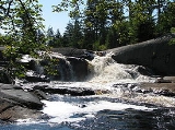
High Falls on the Oswegatchie River
Encyclopedia
High Falls is a small but picturesque waterfall
on the upper Oswegatchie River
in the Five Ponds Wilderness
. It is located in the town of Fine
, in a remote part of Adirondack State Park in St. Lawrence County. The falls drops about 15 feet (4.6 m). Access is by canoe or by maintained hiking trails. The closest public road, near Wanakena
, is almost six miles (circa 9 km) to the north. Trail access is by a short spur from the High Falls Loop Trail. The most direct canoe access is by way of the Oswegatchie River from the Oswegatchie River Inlet on Inlet Road. The waterfall has been designated a scenic special interest area in the New York State Land Master Plan.
gneiss
bedrock. They are surrounded by white pine
forest, somewhat more open than one might expect in an area characterized as old growth forest
. However windstorms in 1950 and in 1995 devastated this part of the Five Ponds Wilderness. The region has been logged and remnants from that era may be found nearby. A logging railroad once ran between Wanakena and High Falls. The Rich Lumber Company built the standard gauge railroad along the Oswegatchie River about 1902 and operated it until 1912. That part of the Five Ponds Wilderness to the south of High Falls still has the largest area of virgin forest in the US Northeast however. It is also the largest trailless area in New York state.
There is no longer a bridge at High Falls, and a canoe is required to gain access to the region further south. The portage around the waterfall itself is short. The former bridge was the crossing for the long-abandoned middle section of the Red Horse Trail. The original trail ran from Wanakena to the Beaver River
, now the Stillwater Reservoir, ten miles (16 km) south of the falls. The Red Horse Trail was one of the oldest Adirondack Mountain Club
(ADK) hiking trails in Adirondack Park, dating back to the 1920s. The five-and-a-half mile (9 km) section running north from Big Burnt Lake / Trout Pond is all that remains of that trail. The Red Horse Trail intersected the old Albany Road, known as the Old Military Road, a half-mile south of High Falls. The Old Military Road was built between 1812–1815, following a much older Indian trail.
Waterfall
A waterfall is a place where flowing water rapidly drops in elevation as it flows over a steep region or a cliff.-Formation:Waterfalls are commonly formed when a river is young. At these times the channel is often narrow and deep. When the river courses over resistant bedrock, erosion happens...
on the upper Oswegatchie River
Oswegatchie River
The Oswegatchie River is a river in northern New York that flows north from the Adirondack Mountains to the Saint Lawrence River at the city of Ogdensburg. The river mouth was the site of a Jesuit mission, Fort de La Présentation, founded in 1749. Also a fur trading post, the village had 3,000...
in the Five Ponds Wilderness
Five Ponds Wilderness Area
The Five Ponds Wilderness Area, an Adirondack Park unit of New York's Forest Preserve, is located in the towns of Fine and Clifton in St. Lawrence County, the town of Webb in Herkimer County and the town of Long Lake in Hamilton County...
. It is located in the town of Fine
Fine, New York
Fine is a town in St. Lawrence County, New York, United States. The population was 1,622 at the 2000 census. The town is named after Judge John Fine, a businessman involved in settling the town....
, in a remote part of Adirondack State Park in St. Lawrence County. The falls drops about 15 feet (4.6 m). Access is by canoe or by maintained hiking trails. The closest public road, near Wanakena
Wanakena, New York
Wanakena is a hamlet located on the shore of Cranberry Lake in the town of Fine in St. Lawrence County, New York, United States. Tourism is a major industry in the area; a small year-round population is supplemented by an influx seasonal residents each Summer...
, is almost six miles (circa 9 km) to the north. Trail access is by a short spur from the High Falls Loop Trail. The most direct canoe access is by way of the Oswegatchie River from the Oswegatchie River Inlet on Inlet Road. The waterfall has been designated a scenic special interest area in the New York State Land Master Plan.
History
At the falls the Oswegatchie flows northwest over glaciated graniteGranite
Granite is a common and widely occurring type of intrusive, felsic, igneous rock. Granite usually has a medium- to coarse-grained texture. Occasionally some individual crystals are larger than the groundmass, in which case the texture is known as porphyritic. A granitic rock with a porphyritic...
gneiss
Gneiss
Gneiss is a common and widely distributed type of rock formed by high-grade regional metamorphic processes from pre-existing formations that were originally either igneous or sedimentary rocks.-Etymology:...
bedrock. They are surrounded by white pine
Eastern White Pine
Pinus strobus, commonly known as the eastern white pine, is a large pine native to eastern North America, occurring from Newfoundland west to Minnesota and southeastern Manitoba, and south along the Appalachian Mountains to the northern edge of Georgia.It is occasionally known as simply white pine,...
forest, somewhat more open than one might expect in an area characterized as old growth forest
Old growth forest
An old-growth forest is a forest that has attained great age , and thereby exhibits unique ecological features. An old growth forest has also usually reached a climax community...
. However windstorms in 1950 and in 1995 devastated this part of the Five Ponds Wilderness. The region has been logged and remnants from that era may be found nearby. A logging railroad once ran between Wanakena and High Falls. The Rich Lumber Company built the standard gauge railroad along the Oswegatchie River about 1902 and operated it until 1912. That part of the Five Ponds Wilderness to the south of High Falls still has the largest area of virgin forest in the US Northeast however. It is also the largest trailless area in New York state.
There is no longer a bridge at High Falls, and a canoe is required to gain access to the region further south. The portage around the waterfall itself is short. The former bridge was the crossing for the long-abandoned middle section of the Red Horse Trail. The original trail ran from Wanakena to the Beaver River
Beaver River (New York)
The Beaver River is a small mountain stream which flows from the Adirondack Mountains to the Black River at Naumberg, north of Lowville in northwestern New York. The Beaver flows through parts of Hamilton, Herkimer, and Lewis counties...
, now the Stillwater Reservoir, ten miles (16 km) south of the falls. The Red Horse Trail was one of the oldest Adirondack Mountain Club
Adirondack Mountain Club
The Adirondack Mountain Club is a nonprofit organization founded in 1922. It has approximately 35,000 members. The ADK is dedicated to the protection and responsible recreational use of the New York State Forest Preserve, parks, wild lands, and waters; it conducts extensive conservation, and...
(ADK) hiking trails in Adirondack Park, dating back to the 1920s. The five-and-a-half mile (9 km) section running north from Big Burnt Lake / Trout Pond is all that remains of that trail. The Red Horse Trail intersected the old Albany Road, known as the Old Military Road, a half-mile south of High Falls. The Old Military Road was built between 1812–1815, following a much older Indian trail.