
Fine, New York
Encyclopedia
Fine is a town
in St. Lawrence County
, New York
, United States
. The population was 1,622 at the 2000 census. The town is named after Judge John Fine, a businessman involved in settling the town.
The Town of Fine is in the south part of the county, south of Canton
.
The New York State Ranger School
is in the eastern part of the town.
The little hamlet of Fine is on the Oswegatchie River about five miles southeasterly from South Edwards. It has been locally known as "Smithville" from William P. Smith, who was an early resident there.
The town was organized in 1849 from parts of the Towns of Pierrepont
and Russell
.
, the town has a total area of 169.4 square miles (438.7 km²), of which, 167.1 square miles (432.8 km²) of it is land and 2.3 square miles (6 km²) of it (1.36%) is water.
The town is within the Adirondack Park.
The south town line is the border of Lewis County
and Herkimer County
.
New York State Route 3
, an east-west highway, crosses the town. New York State Route 58
intersects NY-3 near Fine village.
The Oswegatchie River
flows from Cranberry Lake in a westerly direction through Fine.
of 2000, there were 1,622 people, 667 households, and 452 families residing in the town. The population density
was 9.7 people per square mile (3.7/km²). There were 1,137 housing units at an average density of 6.8 per square mile (2.6/km²). The racial makeup of the town was 97.29% White, 0.68% African American, 0.68% Native American, 0.37% Asian, 0.06% from other races
, and 0.92% from two or more races. Hispanic or Latino of any race were 0.37% of the population.
There were 667 households out of which 25.8% had children under the age of 18 living with them, 54.9% were married couples
living together, 7.5% had a female householder with no husband present, and 32.2% were non-families. 27.1% of all households were made up of individuals and 13.9% had someone living alone who was 65 years of age or older. The average household size was 2.36 and the average family size was 2.83.
In the town the population was spread out with 21.1% under the age of 18, 8.2% from 18 to 24, 26.0% from 25 to 44, 27.7% from 45 to 64, and 17.0% who were 65 years of age or older. The median age was 42 years. For every 100 females there were 97.8 males. For every 100 females age 18 and over, there were 100.0 males.
The median income for a household in the town was $32,112, and the median income for a family was $38,618. Males had a median income of $38,043 versus $20,875 for females. The per capita income
for the town was $16,744. About 13.7% of families and 17.3% of the population were below the poverty line, including 24.1% of those under age 18 and 10.8% of those age 65 or over.
Town
A town is a human settlement larger than a village but smaller than a city. The size a settlement must be in order to be called a "town" varies considerably in different parts of the world, so that, for example, many American "small towns" seem to British people to be no more than villages, while...
in St. Lawrence County
St. Lawrence County, New York
St. Lawrence County is a county located in the U.S. state of New York. As of the 2010 census, the population was 111,944. The county seat is Canton. The county is named for the Saint Lawrence River, which in turn was named for the Catholic saint on whose Feast day the river was discovered by...
, New York
New York
New York is a state in the Northeastern region of the United States. It is the nation's third most populous state. New York is bordered by New Jersey and Pennsylvania to the south, and by Connecticut, Massachusetts and Vermont to the east...
, United States
United States
The United States of America is a federal constitutional republic comprising fifty states and a federal district...
. The population was 1,622 at the 2000 census. The town is named after Judge John Fine, a businessman involved in settling the town.
The Town of Fine is in the south part of the county, south of Canton
Canton (village), New York
Canton is a village in St. Lawrence County, New York, United States. The village is centrally located in both the town of Canton and the county of St. Lawrence. The population was 5,882 at the 2000 census. It is the county seat of St. Lawrence County...
.
The New York State Ranger School
New York State Ranger School
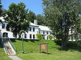
The New York State Ranger School in Wanakena, New York, was founded in 1912 under the administration of the New York State College of Forestry at Syracuse University, to train forest rangers and other personnel for the still-young Adirondack Park....
is in the eastern part of the town.
History
The first settlement was begun by Elias Teall, who made a contract on the 24th of October, 1823, with the proprietors of the east half of Scriba, and undertook to secure settlers on the tract. He built a mill on a branch of the Oswegatchie and made some small improvements; but his undertaking failed. September 6, 1828, James C. Haile made a contract with the proprietors, and built a saw mill and a small grist mill on the Oswegatchie; he induced other settlers to come in. In May, 1833, he also left the town, his settlers having abandoned him. In February, 1834, Arnasa I. Brown contracted with the owners for the Haile improvements and an additional tract of land, and in March of that year moved his family in; his nearest neighbors were ten miles away. A few others soon joined him, and in 1843 there were forty three or forty-four voters.The little hamlet of Fine is on the Oswegatchie River about five miles southeasterly from South Edwards. It has been locally known as "Smithville" from William P. Smith, who was an early resident there.
The town was organized in 1849 from parts of the Towns of Pierrepont
Pierrepont, New York
Pierrepont is a town and hamlet in St. Lawrence County, New York, in the United States. As of the 2000 census, the town population was 2,674. It was named after Hezekiah Pierrepont, the early owner of much of the town's territory. The Town of Pierrepont is centrally located in the county and is...
and Russell
Russell, New York
Russell is a town in St. Lawrence County, New York, United States. The population was 1,801 at the 2000 census. The town is named after Russell Attwater, the pioneer land owner....
.
Geography
According to the United States Census BureauUnited States Census Bureau
The United States Census Bureau is the government agency that is responsible for the United States Census. It also gathers other national demographic and economic data...
, the town has a total area of 169.4 square miles (438.7 km²), of which, 167.1 square miles (432.8 km²) of it is land and 2.3 square miles (6 km²) of it (1.36%) is water.
The town is within the Adirondack Park.
The south town line is the border of Lewis County
Lewis County, New York
As of the census of 2000, there were 26,944 people, 10,040 households, and 7,309 families residing in the county. The population density was 21 people per square mile . There were 15,134 housing units at an average density of 12 per square mile...
and Herkimer County
Herkimer County, New York
Herkimer County is a county located in the U.S. state of New York. It was created in 1791 north of the Mohawk River out of part of Montgomery County. As of the 2010 census, the population was 64,519. It is named after General Nicholas Herkimer, who died from battle wounds in 1777 after taking part...
.
New York State Route 3
New York State Route 3
New York State Route 3 is a major east–west state highway in New York, United States, that connects central New York to the North Country region near the Canadian border via Adirondack Park. The route extends for between its western terminus at an intersection with NY 104A in the Cayuga...
, an east-west highway, crosses the town. New York State Route 58
New York State Route 58
New York State Route 58 is a north–south state highway located in St. Lawrence County, New York, United States. The highway runs in a northwest to southeast direction as it traverses the county. The southern terminus of the route is at a junction with NY 3 in the hamlet of Fine within...
intersects NY-3 near Fine village.
The Oswegatchie River
Oswegatchie River
The Oswegatchie River is a river in northern New York that flows north from the Adirondack Mountains to the Saint Lawrence River at the city of Ogdensburg. The river mouth was the site of a Jesuit mission, Fort de La Présentation, founded in 1749. Also a fur trading post, the village had 3,000...
flows from Cranberry Lake in a westerly direction through Fine.
Demographics
As of the censusCensus
A census is the procedure of systematically acquiring and recording information about the members of a given population. It is a regularly occurring and official count of a particular population. The term is used mostly in connection with national population and housing censuses; other common...
of 2000, there were 1,622 people, 667 households, and 452 families residing in the town. The population density
Population density
Population density is a measurement of population per unit area or unit volume. It is frequently applied to living organisms, and particularly to humans...
was 9.7 people per square mile (3.7/km²). There were 1,137 housing units at an average density of 6.8 per square mile (2.6/km²). The racial makeup of the town was 97.29% White, 0.68% African American, 0.68% Native American, 0.37% Asian, 0.06% from other races
Race (United States Census)
Race and ethnicity in the United States Census, as defined by the Federal Office of Management and Budget and the United States Census Bureau, are self-identification data items in which residents choose the race or races with which they most closely identify, and indicate whether or not they are...
, and 0.92% from two or more races. Hispanic or Latino of any race were 0.37% of the population.
There were 667 households out of which 25.8% had children under the age of 18 living with them, 54.9% were married couples
Marriage
Marriage is a social union or legal contract between people that creates kinship. It is an institution in which interpersonal relationships, usually intimate and sexual, are acknowledged in a variety of ways, depending on the culture or subculture in which it is found...
living together, 7.5% had a female householder with no husband present, and 32.2% were non-families. 27.1% of all households were made up of individuals and 13.9% had someone living alone who was 65 years of age or older. The average household size was 2.36 and the average family size was 2.83.
In the town the population was spread out with 21.1% under the age of 18, 8.2% from 18 to 24, 26.0% from 25 to 44, 27.7% from 45 to 64, and 17.0% who were 65 years of age or older. The median age was 42 years. For every 100 females there were 97.8 males. For every 100 females age 18 and over, there were 100.0 males.
The median income for a household in the town was $32,112, and the median income for a family was $38,618. Males had a median income of $38,043 versus $20,875 for females. The per capita income
Per capita income
Per capita income or income per person is a measure of mean income within an economic aggregate, such as a country or city. It is calculated by taking a measure of all sources of income in the aggregate and dividing it by the total population...
for the town was $16,744. About 13.7% of families and 17.3% of the population were below the poverty line, including 24.1% of those under age 18 and 10.8% of those age 65 or over.
Communities and locations in Fine
- Aldrich – A hamletHamlet (place)A hamlet is usually a rural settlement which is too small to be considered a village, though sometimes the word is used for a different sort of community. Historically, when a hamlet became large enough to justify building a church, it was then classified as a village...
south of Coffin Mills. - Briggs – A hamlet near the west town line, west of Coffin Mills.
- Coffin Mills – A hamlet southwest of Oswegatchie village.
- Fine – The hamlet of Fine is in the northern part of the town by the Oswegatchie River. It was originally known as "Smithville","Andersonville" and Sarahsburg from an early resident.
- Inlet – A location west of Wanakena.
- Jayville – A hamlet at the west town line, west of Briggs.
- Lower Oswegatchie – A hamlet on NY-3, located in east part of the town and north of Oswegatchie village.
- Oswegatchie – A hamlet on NY-3, located in eastern part of the town. This settlement grew to importance as a railroad community.
- Star Lake – A lakeLakeA lake is a body of relatively still fresh or salt water of considerable size, localized in a basin, that is surrounded by land. Lakes are inland and not part of the ocean and therefore are distinct from lagoons, and are larger and deeper than ponds. Lakes can be contrasted with rivers or streams,...
in the east part of the town. - Star LakeStar Lake, New YorkStar Lake is a hamlet in the Adirondack Mountains St. Lawrence County, New York, United States. The population was 860 at the 2000 census.Star Lake is in the Town of Clifton, but part of the community is in the Town of Fine....
– A hamlet located on the east town line and east of Star Lake on NY-3. Most of the community is in the Town of CliftonClifton, New YorkClifton is a town in St. Lawrence County, New York, United States. The population was 791 at the 2000 census. The town takes its name from a mining company.The Town of Clifton is in the south part of the county, within the Adirondack Park....
. Star Lake is also the location for the Clifton-Fine Central School District. - WanakenaWanakena, New YorkWanakena is a hamlet located on the shore of Cranberry Lake in the town of Fine in St. Lawrence County, New York, United States. Tourism is a major industry in the area; a small year-round population is supplemented by an influx seasonal residents each Summer...
– A hamlet located on County Road 61 on an arm of Cranberry LakeCranberry LakeCranberry Lake is a lake on the Oswegatchie River in the Adirondack Park in New York in the United States. It is the third largest lake in the Adirondack Park Cranberry Lake is a lake on the Oswegatchie River in the Adirondack Park in New York in the United States. It is the third largest lake in...
in the southeastern part of the town. It is the site of the Ranger School, part of the State University of New York College of Environmental Science and ForestryState University of New York College of Environmental Science and ForestryThe State University of New York College of Environmental Science and Forestry is an American specialized doctoral-granting institution located in the University Hill neighborhood of Syracuse, New York, immediately adjacent to Syracuse University...
.