
Hard Knott
Encyclopedia
Hard Knott is a hill in the English
Lake District
, at the head of Eskdale
.
and the Duddon
are separated by a ridge falling south west from the summit of Crinkle Crags
. This line of high ground continues over many twists and turns for 15 miles (24 km), finally meeting the sea on the slopes of Black Combe
. From Crinkle Crags the first fell on this ridge is Hard Knott, followed by Harter Fell
and Green Crag
. Alfred Wainwright
did not include the remainder of the ridge in his influential ‘’Pictorial Guide to the Lakeland Fells
’’, but later guidebook writers have disagreed, adding Great Worm Crag, Yoadcastle, Whitfell
, Buck Barrow, Black Combe and the low hills around Devoke Water
to their main volumes. Wainwright himself later relented and included these lesser hills in a supplementary volume, The Outlying Fells of Lakeland.
From the main ridge of Crinkle Crags a low saddle juts out to the west in the vicinity of the southernmost Crinkle. This separates the basin of upper Eskdale from the head of the small marshy valley of Moasdale, down which the Moasdale Beck flows south to join the River Duddon at Cockley Beck. To the west of the saddle the ridge turns southward and gains height, rising over a series of rocky knolls to the summit of Hard Knott. The Moasdale side has gentle gradients but the western flanks above the Esk are fringed with crags. One feature on this side is the Eskdale Needle, (also known as The Steeple) a finger of rock detached from the main face. As the Esk and Moasdale Becks diverge, the girth of the fell increases, until a pair of side valleys intrude to nip off its southward progress. These streams, both named Hard Knott Gill, fall from either side of Hardknott Pass
, beyond which the ridge climbs again over a series of crags toward Harter Fell.
The Hardknott Pass joins Eskdale with the Duddon Valley
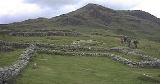
. There is a steep single-track motor road over the pass with gradients of up to 30% (1 in 3), reaching a maximum height of 393 metres (1,289 ft). The Hardknott Roman Fort
stands at a height of approximately 200 metres (656 ft) on the lower slopes of the western ridge as it descends into Eskdale
. A roman road from Ravenglass to Ambleside once crossed the pass, although by a slightly different route.
lava
-like tuff
of the Bad Step Tuff forms the summit rocks with the dacitic
lapilli
-tuffs of the Lincomb Tarns Formation to the north west. Border end shows outcropping plagioclase
-phyric andesite
lavas of the Birker Fell Formation.
. There are other named tops on the ridge in addition to the summit, with Yew Bank to the north and Border End to the south. Hard Knott is famous for its superb view of the Scafell massif to the north, while Harter Fell dominates the vista to the south. For a fabulous view of Eskdale it is recommended that the walker visits Border End half a mile to the south of the main summit.
is usually climbed from the top of the Hardknott Pass
where there are several parking spaces. It is also possible to begin the ascent from the foot of the pass in Eskdale, although this will triple the length of the walk and the height gained. However, the best plan is probably to climb Hard Knott in conjunction with the neighbouring fell of Harter Fell making a horseshoe walk starting and finishing in Eskdale. From the top of the pass it is a short ascent to the fell summit following an electric fence that skirts to the right of the dangerous looking Raven Crag and takes the walker to the summit in a short time. Other possible routes include a pathless ascent from the Esk via The Steeple, a circuitous walk via the head of Moasdale and an ascent of the eastern flanks via Dod Pike.
England
England is a country that is part of the United Kingdom. It shares land borders with Scotland to the north and Wales to the west; the Irish Sea is to the north west, the Celtic Sea to the south west, with the North Sea to the east and the English Channel to the south separating it from continental...
Lake District
Lake District
The Lake District, also commonly known as The Lakes or Lakeland, is a mountainous region in North West England. A popular holiday destination, it is famous not only for its lakes and its mountains but also for its associations with the early 19th century poetry and writings of William Wordsworth...
, at the head of Eskdale
Eskdale, Cumbria
Eskdale is a glacial valley and civil parish in the western Lake District National Park in Cumbria, England. It forms part of the Borough of Copeland, and has a population of 264....
.
Topography
The headwaters of the River EskRiver Esk, Cumbria
The River Esk is a river in the Lake District in Cumbria, England. It is one of two River Esks in Cumbria, and not to be confused with the River Esk which flows on the Scottish side of the border....
and the Duddon
River Duddon
The Duddon is a river of north-west England. It rises at a point above sea level near the Three Shire Stone at the highest point of Wrynose Pass . The river descends to the sea over a course of about before entering the Irish Sea at the Duddon Sands. For its entire length the Duddon forms the...
are separated by a ridge falling south west from the summit of Crinkle Crags
Crinkle Crags
Crinkle Crags is a fell in the English Lake District in the county of Cumbria. It forms part of two major rings of mountains, surrounding the valleys of Great Langdale and Upper Eskdale. The name reflects the fell's physical appearance as its summit ridge is a series of five rises and depressions ...
. This line of high ground continues over many twists and turns for 15 miles (24 km), finally meeting the sea on the slopes of Black Combe
Black Combe
Black Combe is a fell in the south-west corner of the Lake District National Park, just four miles from the Irish Sea. It lies near the west coast of Cumbria in the borough of Copeland and more specifically, an area known as South Copeland...
. From Crinkle Crags the first fell on this ridge is Hard Knott, followed by Harter Fell
Harter Fell (Eskdale)
Harter Fell is a mountain in the western part of the English Lake District located between the Eskdale and Duddon valleys. Its height is 649 m . There are several walking routes to the summit.-Topography:...
and Green Crag
Green Crag
Green Crag is a fell in the English Lake District. It stands between Eskdale and the Duddon valley in the Southern Fells.-Topography:The headwaters of Eskdale and the Duddon are separated by a ridge falling south west from the summit of Crinkle Crags. This line of high ground continues over many...
. Alfred Wainwright
Alfred Wainwright
Alfred Wainwright MBE was a British fellwalker, guidebook author and illustrator. His seven-volume Pictorial Guide to the Lakeland Fells, published between 1955 and 1966 and consisting entirely of reproductions of his manuscript, has become the standard reference work to 214 of the fells of the...
did not include the remainder of the ridge in his influential ‘’Pictorial Guide to the Lakeland Fells
Pictorial Guide to the Lakeland Fells
A Pictorial Guide to the Lakeland Fells is a series of seven books by A. Wainwright, detailing the fells of the Lake District in northwest England...
’’, but later guidebook writers have disagreed, adding Great Worm Crag, Yoadcastle, Whitfell
Whitfell
Whitfell is a hill in the southwestern part of the Lake District. It is the highest point between Black Combe and Harter Fell on the broad ridge to the west of the Duddon Valley...
, Buck Barrow, Black Combe and the low hills around Devoke Water
Devoke Water
Devoke Water is a small lake in the mid-west region of the English Lake District, in the county of Cumbria. It is the largest tarn in the Lake District....
to their main volumes. Wainwright himself later relented and included these lesser hills in a supplementary volume, The Outlying Fells of Lakeland.
From the main ridge of Crinkle Crags a low saddle juts out to the west in the vicinity of the southernmost Crinkle. This separates the basin of upper Eskdale from the head of the small marshy valley of Moasdale, down which the Moasdale Beck flows south to join the River Duddon at Cockley Beck. To the west of the saddle the ridge turns southward and gains height, rising over a series of rocky knolls to the summit of Hard Knott. The Moasdale side has gentle gradients but the western flanks above the Esk are fringed with crags. One feature on this side is the Eskdale Needle, (also known as The Steeple) a finger of rock detached from the main face. As the Esk and Moasdale Becks diverge, the girth of the fell increases, until a pair of side valleys intrude to nip off its southward progress. These streams, both named Hard Knott Gill, fall from either side of Hardknott Pass
Hardknott Pass
Hardknott Pass is a pass that carries a minor road between Eskdale and the Duddon Valley in the region of Cumbria, England, in the Lake District National Park...
, beyond which the ridge climbs again over a series of crags toward Harter Fell.
The Hardknott Pass joins Eskdale with the Duddon Valley
Duddon Valley
The Duddon Valley is a valley in the Lake District National Park in Cumbria, England. The River Duddon flows through the valley, rising in the mountains between Eskdale and Langdale, before flowing into the Irish Sea near Broughton in Furness...
. There is a steep single-track motor road over the pass with gradients of up to 30% (1 in 3), reaching a maximum height of 393 metres (1,289 ft). The Hardknott Roman Fort
Hardknott Roman Fort
Mediobogdum was a fort in the Roman province of Britannia. Its remains are located on the western side of the Hardknott Pass in the English county of Cumbria .-The location and name:...
stands at a height of approximately 200 metres (656 ft) on the lower slopes of the western ridge as it descends into Eskdale
Eskdale, Cumbria
Eskdale is a glacial valley and civil parish in the western Lake District National Park in Cumbria, England. It forms part of the Borough of Copeland, and has a population of 264....
. A roman road from Ravenglass to Ambleside once crossed the pass, although by a slightly different route.
Geology
RhyoliticRhyolite
This page is about a volcanic rock. For the ghost town see Rhyolite, Nevada, and for the satellite system, see Rhyolite/Aquacade.Rhyolite is an igneous, volcanic rock, of felsic composition . It may have any texture from glassy to aphanitic to porphyritic...
lava
Lava
Lava refers both to molten rock expelled by a volcano during an eruption and the resulting rock after solidification and cooling. This molten rock is formed in the interior of some planets, including Earth, and some of their satellites. When first erupted from a volcanic vent, lava is a liquid at...
-like tuff
Tuff
Tuff is a type of rock consisting of consolidated volcanic ash ejected from vents during a volcanic eruption. Tuff is sometimes called tufa, particularly when used as construction material, although tufa also refers to a quite different rock. Rock that contains greater than 50% tuff is considered...
of the Bad Step Tuff forms the summit rocks with the dacitic
Dacite
Dacite is an igneous, volcanic rock. It has an aphanitic to porphyritic texture and is intermediate in composition between andesite and rhyolite. The relative proportions of feldspars and quartz in dacite, and in many other volcanic rocks, are illustrated in the QAPF diagram...
lapilli
Lapilli
Lapilli is a size classification term for tephra, which is material that falls out of the air during a volcanic eruption or during some meteorite impacts. Lapilli means "little stones" in Latin. They are in some senses similar to ooids or pisoids in calcareous sediments.By definition lapilli range...
-tuffs of the Lincomb Tarns Formation to the north west. Border end shows outcropping plagioclase
Plagioclase
Plagioclase is an important series of tectosilicate minerals within the feldspar family. Rather than referring to a particular mineral with a specific chemical composition, plagioclase is a solid solution series, more properly known as the plagioclase feldspar series...
-phyric andesite
Andesite
Andesite is an extrusive igneous, volcanic rock, of intermediate composition, with aphanitic to porphyritic texture. In a general sense, it is the intermediate type between basalt and dacite. The mineral assemblage is typically dominated by plagioclase plus pyroxene and/or hornblende. Magnetite,...
lavas of the Birker Fell Formation.
Summit and view
Hard Knott reaches a height of 549 metres (1,803 feet), the summit knoll bearing a cairnCairn
Cairn is a term used mainly in the English-speaking world for a man-made pile of stones. It comes from the or . Cairns are found all over the world in uplands, on moorland, on mountaintops, near waterways and on sea cliffs, and also in barren desert and tundra areas...
. There are other named tops on the ridge in addition to the summit, with Yew Bank to the north and Border End to the south. Hard Knott is famous for its superb view of the Scafell massif to the north, while Harter Fell dominates the vista to the south. For a fabulous view of Eskdale it is recommended that the walker visits Border End half a mile to the south of the main summit.
Ascents
The fellFell
“Fell” is a word used to refer to mountains, or certain types of mountainous landscape, in Scandinavia, the Isle of Man, and parts of northern England.- Etymology :...
is usually climbed from the top of the Hardknott Pass
Hardknott Pass
Hardknott Pass is a pass that carries a minor road between Eskdale and the Duddon Valley in the region of Cumbria, England, in the Lake District National Park...
where there are several parking spaces. It is also possible to begin the ascent from the foot of the pass in Eskdale, although this will triple the length of the walk and the height gained. However, the best plan is probably to climb Hard Knott in conjunction with the neighbouring fell of Harter Fell making a horseshoe walk starting and finishing in Eskdale. From the top of the pass it is a short ascent to the fell summit following an electric fence that skirts to the right of the dangerous looking Raven Crag and takes the walker to the summit in a short time. Other possible routes include a pathless ascent from the Esk via The Steeple, a circuitous walk via the head of Moasdale and an ascent of the eastern flanks via Dod Pike.