
Hanson Memorial Highway
Encyclopedia
Route 460 is a Canadian
provincial highway in Newfoundland and Labrador
.
It is located on the west coast of the island of Newfoundland and has its western terminus at Cape St. George
, the westernmost tip of the Port au Port Peninsula
, and its eastern terminus at an interchange in Harrys Brook
with Highway 1, the Trans-Canada Highway
.
The highway has developed in several distinct sections:
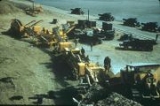
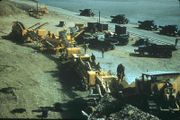 The US Army Corps of Engineers began work on the Stephenville bypass road in the 1950s. Company C, under the command of Capt. Claxton Ray, began at Stephenville and worked towards Company B, under the command of Capt. Gomez, which had commenced construction near Cormiers Village and were working in both directions, towards Long Gull Pond
and towards Stephenville. It was necessary for Company B to begin construction of the road at Cormiers Village and work back towards Stephenville pending the finalizing of property agreements.
The eleven mile (18 km) long highway construction project began with a line of corduroy roads comprising one half of the road, and when Long Gull Pond was reached in the fall of 1954, the other half was constructed. The road was then extended along the Newfoundland Railway
main line from Long Gull Pond to Stephenville Crossing
(this section is now the eastern terminus of Route 461.
It was necessary to build three access roads approximately two miles in length in order to facilitate construction of the bypass road. These roads were built to the same specifications as the bypass road as they were used constantly for heavy hauling. A concrete
bridge was built over Cold Creek in 1954 and a 60 foot (20 m) concrete bridge was built over Warm Creek in 1956.
The project required 90,000 cubic yards (70,000 m³) of fill as well as 30,000 cubic yards (20,000 m³) of crushed rock to complete the sub-base. The travel surface required 15,000 cubic yards (10,000 m³) of gravel, 19 inches thick before asphalt was applied. Construction equipment and material were stored at a depot Long Gull Pond during the project.
The bypass road was officially opened for military and public users in October 1957.
Canada
Canada is a North American country consisting of ten provinces and three territories. Located in the northern part of the continent, it extends from the Atlantic Ocean in the east to the Pacific Ocean in the west, and northward into the Arctic Ocean...
provincial highway in Newfoundland and Labrador
Newfoundland and Labrador
Newfoundland and Labrador is the easternmost province of Canada. Situated in the country's Atlantic region, it incorporates the island of Newfoundland and mainland Labrador with a combined area of . As of April 2011, the province's estimated population is 508,400...
.
It is located on the west coast of the island of Newfoundland and has its western terminus at Cape St. George
Cape St. George, Newfoundland and Labrador
Cape St. George is a headland and community of the same name, located at the southwestern tip of the Port au Port Peninsula on the Canadian island of Newfoundland.The headland marks the northwestern limit of St...
, the westernmost tip of the Port au Port Peninsula
Port au Port Peninsula
The Port au Port Peninsula is a peninsula in the Canadian province of Newfoundland and Labrador. Roughly triangular in shape, it is located on the west coast of the island of Newfoundland.-Geography:...
, and its eastern terminus at an interchange in Harrys Brook
Harry's Brook, Newfoundland and Labrador
-See also:* List of communities in Newfoundland and Labrador...
with Highway 1, the Trans-Canada Highway
Trans-Canada Highway
The Trans-Canada Highway is a federal-provincial highway system that joins the ten provinces of Canada. It is, along with the Trans-Siberian Highway and Australia's Highway 1, one of the world's longest national highways, with the main route spanning 8,030 km...
.
The highway has developed in several distinct sections:
- Harrys Brook to interchange with Route 461 at Long Gull PondLong Gull PondLong Gull Pond is a -long lake located in the western part of the island of Newfoundland in the Canadian province of Newfoundland and Labrador.Route 460 runs along its southern shore, connecting Stephenville and Stephenville Crossing....
(17 km) was developed at the time that the Trans-Canada Highway was built across Newfoundland in the early 1960s, this section is known as White's Road.
- Long Gull Pond to interchange with Route 490 at StephenvilleStephenville, Newfoundland and LabradorStephenville is a Canadian town in Newfoundland and Labrador on the west coast of the island of Newfoundland....
(16 km), the Hansen Memorial Highway, was developed by the US Army Corps of EngineersUnited States Army Corps of EngineersThe United States Army Corps of Engineers is a federal agency and a major Army command made up of some 38,000 civilian and military personnel, making it the world's largest public engineering, design and construction management agency...
to run from Ernest Harmon AFBErnest Harmon Air Force BaseErnest Harmon Air Force Base is a former United States Air Force base located in Stephenville, Newfoundland and Labrador. The base was built by the United States Army Air Forces in 1941 under the Destroyers for Bases Agreement with the United Kingdom....
to the Newfoundland RailwayNewfoundland RailwayThe Newfoundland Railway was a railway which operated on the island of Newfoundland from 1898 to 1988. With a total track length of , it was the longest narrow gauge railway system in North America.-Early construction:...
main line at Long Gull Pond. Later, the USACE constructed its own narrow gauge railway line to connect the base with the main line, parallel to the Hansen Memorial Highway.
- Interchange with Route 490 at Stephenville to western boundary of KippensKippens, Newfoundland and LabradorKippens is a Canadian town located in the province of Newfoundland and Labrador on the west coast of the island of Newfoundland....
(4.5 km), known as Kippens Road.
- Continuation from western boundary of Kippens through Port au PortPort au Port, Newfoundland and LabradorPort au Port is a small Canadian rural community located in the western part of the island of Newfoundland. Port au Port is situated on the isthmus connecting the main part of the island of Newfoundland to the Port au Port Peninsula to the west. Port au Port is located on Route 460, several...
and along the south coast of the Port au Port PeninsulaPort au Port PeninsulaThe Port au Port Peninsula is a peninsula in the Canadian province of Newfoundland and Labrador. Roughly triangular in shape, it is located on the west coast of the island of Newfoundland.-Geography:...
to Cape St. GeorgeCape St. George, Newfoundland and LabradorCape St. George is a headland and community of the same name, located at the southwestern tip of the Port au Port Peninsula on the Canadian island of Newfoundland.The headland marks the northwestern limit of St...
(51 km), the Port au Port Highway.
Construction history for Hansen Memorial Highway section
Long Gull Pond
Long Gull Pond is a -long lake located in the western part of the island of Newfoundland in the Canadian province of Newfoundland and Labrador.Route 460 runs along its southern shore, connecting Stephenville and Stephenville Crossing....
and towards Stephenville. It was necessary for Company B to begin construction of the road at Cormiers Village and work back towards Stephenville pending the finalizing of property agreements.
The eleven mile (18 km) long highway construction project began with a line of corduroy roads comprising one half of the road, and when Long Gull Pond was reached in the fall of 1954, the other half was constructed. The road was then extended along the Newfoundland Railway
Newfoundland Railway
The Newfoundland Railway was a railway which operated on the island of Newfoundland from 1898 to 1988. With a total track length of , it was the longest narrow gauge railway system in North America.-Early construction:...
main line from Long Gull Pond to Stephenville Crossing
Stephenville Crossing, Newfoundland and Labrador
Stephenville Crossing is a Canadian town in the province of Newfoundland and Labrador on the island of Newfoundland. The town is located at the easternmost limit of Bay St...
(this section is now the eastern terminus of Route 461.
It was necessary to build three access roads approximately two miles in length in order to facilitate construction of the bypass road. These roads were built to the same specifications as the bypass road as they were used constantly for heavy hauling. A concrete
Concrete
Concrete is a composite construction material, composed of cement and other cementitious materials such as fly ash and slag cement, aggregate , water and chemical admixtures.The word concrete comes from the Latin word...
bridge was built over Cold Creek in 1954 and a 60 foot (20 m) concrete bridge was built over Warm Creek in 1956.
The project required 90,000 cubic yards (70,000 m³) of fill as well as 30,000 cubic yards (20,000 m³) of crushed rock to complete the sub-base. The travel surface required 15,000 cubic yards (10,000 m³) of gravel, 19 inches thick before asphalt was applied. Construction equipment and material were stored at a depot Long Gull Pond during the project.
The bypass road was officially opened for military and public users in October 1957.