

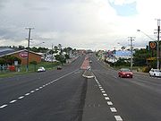
Gympie Road, Brisbane
Encyclopedia
Brisbane
Brisbane is the capital and most populous city in the Australian state of Queensland and the third most populous city in Australia. Brisbane's metropolitan area has a population of over 2 million, and the South East Queensland urban conurbation, centred around Brisbane, encompasses a population of...
, Queensland, Australia. The road forms part of the main road route from the Brisbane Central Business District (CBD) to the northern suburbs, Sunshine Coast
Sunshine Coast, Queensland
The Sunshine Coast is an urban area in South East Queensland, north of the state capital of Brisbane on the Pacific Ocean coastline. Although it does not have a central business district, by population it ranks as the 10th largest metropolis in Australia and the third largest in...
and east coast of Queensland
Queensland
Queensland is a state of Australia, occupying the north-eastern section of the mainland continent. It is bordered by the Northern Territory, South Australia and New South Wales to the west, south-west and south respectively. To the east, Queensland is bordered by the Coral Sea and Pacific Ocean...
.
Gympie road is designated A3 from Lutwyche Road, Kedron to the Gympie Arterial Road, Bald Hills. The road then continues as State Route 58 to Dayboro Road, Petrie.
Gympie Road is named after the town of Gympie, north of the Sunshine Coast.
Landmarks
Gympie Road is lined with many shops, fast food outlets, restaurants, car yards, factories, motels, caravan parks, parks and schools including:- Kedron Park Hotel (est. 1881)
- Kedron BrookKedron BrookKedron Brook is a creek that flows through the northern suburbs of Brisbane, Australia. It starts near the outer suburb of Upper Kedron and flows in an easterly direction...
- Lutwyche Cemetery
- Top TasteGeorge Weston FoodsGeorge Weston Foods is one of the largest consumer products companies in Australia. It is a wholly owned subsidiary of Associated British Foods Plc. Its brands include Tip Top and Top Taste....
- Edinburgh Castle Hotel (est. 1868)
- Westfield ChermsideWestfield ChermsideWestfield Chermside is the largest shopping centre in Queensland, located in Brisbane's inner northern suburbs, the second-largest in Australia, behind Chadstone Shopping Centre in Melbourne, and is operated by the Westfield Group. Entertainment facilities include an Event Cinemas 16-screen cinema...
- Marchant Park
- Bunnings WarehouseBunnings WarehouseBunnings Warehouse is Australia's largest hardware chain with stores in Australia and New Zealand. The chain is owned by Wesfarmers Limited.-History:-Pre 1900s:...
- The WarehouseThe Warehouse GroupThe Warehouse Group Limited, founded by Stephen Tindall in 1982, is the largest department store retailer operating in New Zealand. The Warehouse is largely a discount store similar to Wal-Mart in the United States, however The Warehouse sells far more generic brand merchandise than other discount...
- Bald Hill Primary School
- St Pauls School
- Pine Rivers Park
- Westfield StrathpineWestfield StrathpineWestfield Strathpine is a regional shopping centre located in Strathpine, a suburb in Moreton Bay, north of Brisbane.The centre was built and opened in 1983 by The Westfield Group. It is anchored by Big W and Target discount department stores, Woolworths supermarket, Coles supermarket and ALDI Food...
- Pine Rivers High School
- Strathpine Primary School
Past
The route was formerly part of the Bruce HighwayBruce Highway
The Bruce Highway is a major highway in Queensland, Australia. Commencing in the state capital, Brisbane, it passes through areas close to the eastern coast to Cairns in Far North Queensland. The route is a part of the Australian National Highway and also part of Highway 1...
and carried the designation National Route 1 until the Gateway Bridge
Gateway Bridge, Brisbane
The Sir Leo Hielscher Bridges are a pair of road bridges on the Gateway Motorway , which skirts the eastern suburbs of Brisbane, Queensland, Australia. They are the most eastern crossing of the Brisbane River, the closest to Moreton Bay, crossing at the Quarries Reach, between Eagle Farm and Murarrie...
opened in 1986. The route has since had the designations of Alt Route 1 and Metroad 3.
The first private land sale occurred on Gympie Road near Kedron Brook in 1857. Farms, slaughter yards and tanneries were common sites along Gympie Road prior to World War I. The first integrated shopping centre in Queensland opened on the corner of Hamilton Road, Chermside in 1957.
The tram line from the CBD was extended to Kedron Park Hotel in 1914, Lutwyche Cemetery in 1925 and Chermside in 1947. The tram service was closed in 1968 and replaced with diesel buses.
Future
TransLinkTransLink (South East Queensland)
The TransLink Transit Authority is the authority introduced by the Queensland Government in June 2003 as a section of Queensland Transport to coordinate and integrate rail, bus and ferry services. TransLink works with Airtrain, Brisbane Transport, Brisbane Ferries, QR Citytrain and 17 other...
is planning for the Kedron to Bracken Ridge section of the Northern Busway that will generally follow Gympie Road.