

Gwydir Forest
Encyclopedia
Wales
Wales is a country that is part of the United Kingdom and the island of Great Britain, bordered by England to its east and the Atlantic Ocean and Irish Sea to its west. It has a population of three million, and a total area of 20,779 km²...
. It takes its name from the ancient Gwydir Estate, established by the John Wynn
Sir John Wynn, 1st Baronet
Sir John Wynn, 1st Baronet , Welsh baronet, Member of Parliament and antiquary, was the son of Morys Wynn ap John. He claimed to be directly descended from the princes of Gwynedd through Rhodri ab Owain son of Owain Gwynedd. However, this claim is disputed in a publication of 1884 entitled...
family of Gwydir Castle
Gwydir Castle
Gwydir Castle is situated in the Conwy valley, North Wales, a mile to the west of the ancient market town of Llanrwst and to the south of the large village of Trefriw...
, which owned this area.
The Forestry Commission
Forestry Commission
The Forestry Commission is a non-ministerial government department responsible for forestry in Great Britain. Its mission is to protect and expand Britain's forests and woodlands and increase their value to society and the environment....
uses the alternative spelling (i.e. Gwydyr Forest, Coedwig Gwydyr). Certainly as early as 1536, Leland wrote - "Gwydir lieth two bowshots above the River Conwy. It is a pretty place."
Geography of the forest
The forest broadly encircles the village of Betws-y-CoedBetws-y-Coed
Betws-y-Coed is a village and community in the Conwy valley in Conwy County Borough, Wales. It has a population of 534. The name Betws or Bettws is generally thought to be derived from the Anglo-Saxon Old English 'bed-hus' - i.e. a bead-house - a house of prayer, or oratory...
, and much of its mid-section lies within the parish. It reaches northwards to the village of Trefriw
Trefriw
Trefriw is a village in Conwy County Borough, Wales. It lies on the river Conwy in North Wales, a few miles south of the site of the Roman fort of Canovium, sited at Caerhun. The parish population in 2001 was 924....
, and southwards to the village of Penmachno
Penmachno
Penmachno is a village in the isolated upland valley of Cwm Penmachno, 4 miles south of Betws-y-Coed in the county of Conwy, north Wales.It is renowned as the home of Bishop William Morgan , who lived at Tŷ Mawr, Y Wybrnant, near the village. He was one of the leading scholars of his day, having...
. It covers an area of over 72.5 square kilometres, including 49 square kilometres of productive woodland.
Certainly there would have been a certain amount of natural tree growth on these hills thousands of years ago. More recently, records from the 18th century refer to the rafting of timber down the river Conwy
River Conwy
The River Conwy is a river in north Wales. From its source to its discharge in Conwy Bay it is a little over long. "Conwy" is sometimes Anglicized as "Conway."...
. In the 19th century use was made of the quay at Trefriw
Trefriw
Trefriw is a village in Conwy County Borough, Wales. It lies on the river Conwy in North Wales, a few miles south of the site of the Roman fort of Canovium, sited at Caerhun. The parish population in 2001 was 924....
for the shipment of timber to the coast. In 1778, referring to Carreg-y-Gwalch, just above Gwydir Uchaf, Thomas Pennant
Thomas Pennant
Thomas Pennant was a Welsh naturalist and antiquary.The Pennants were a Welsh gentry family from the parish of Whitford, Flintshire, who had built up a modest estate at Bychton by the seventeenth century...
was told that "the noblest oaks in all Wales grew on this rock within living memory."
The forest occupies an undulating plateau, reaching to between 700 and 1000 feet (304.8 m) above sea level, which is divided by the valleys of the rivers Llugwy
River Llugwy
The River Llugwy is a tributary of the River Conwy, and has its source at Ffynnon Llugwy, a lake in the Carneddau range of mountains in Snowdonia.-Location and catchment area :...
, Lledr
River Lledr
The River Lledr is a river in North Wales and the second major tributary of the River Conwy.The Lledr has its source on the eastern slopes of Ysgafell Wen, which lies between Moel Siabod and Cnicht...
, and Machno
River Machno
The River Machno is a river in Snowdonia, North Wales. It is the first major tributary of the River Conwy, which it joins south of Betws-y-coed, just past the impressive Penmachno Falls....
, all of which are tributaries of the river Conwy
River Conwy
The River Conwy is a river in north Wales. From its source to its discharge in Conwy Bay it is a little over long. "Conwy" is sometimes Anglicized as "Conway."...
. Despite being a forest, much of it is not dark and enclosed, and it offers fine views over these valleys, with further views to the mountains of the Glyderau
Glyderau
The Glyderau are a mountain group in Snowdonia, North Wales. The name derives from the highest peaks in the range, Glyder Fawr and Glyder Fach....
, the Carneddau
Carneddau
The Carneddau , are a group of mountains in Snowdonia, Wales. It includes the largest contiguous areas of high ground in Wales and England, as well as six or seven of the highest peaks in the country—the Fourteen Peaks...
and the Snowdon
Snowdon
Snowdon is the highest mountain in Wales, at an altitude of above sea level, and the highest point in the British Isles outside Scotland. It is located in Snowdonia National Park in Gwynedd, and has been described as "probably the busiest mountain in Britain"...
massif itself.
The forested areas occupy the steep slopes and poorer soils of the plateau, the best of the soil being in the agricultural valley bottoms. Rainfall in the forest varies from under 50 inches (1270 mm) to over 80 inches (2032 mm) p.a.
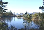
The forest is home to numerous lakes, all of which are reachable by footpaths, and nearly all of which were created to serve the mines of the Forest. In order of size, these include:
- Llyn CrafnantLlyn CrafnantLlyn Crafnant is a lake that lies in a beautiful valley in North Wales where the northern edge of the Gwydir Forest meets the lower slopes of the Carneddau mountains and, more specifically, the ridge of Cefn Cyfarwydd. The head of the valley offers a profile of crags which are silhouetted at...
63 acres (254,952.2 m²) - on the northern edge of the forest - Llyn GeirionyddLlyn GeirionyddLlyn Geirionydd lies in a valley in North Wales where the northern edge of the Gwydyr Forest meets the lower slopes of the Carneddau mountains. The lake is almost a mile long and covers an area of , but is never any deeper than according to Jehu’s survey ...
45 acres (182,108.7 m²) - Llyn ElsiLlyn ElsiLlyn Elsi is a lake located above the village of Betws-y-coed in the Snowdonia National Park in North Wales. It is a reservoir providing water for the village....
26 acres (105,218.4 m²) - Llyn ParcLlyn ParcLlyn Park is a lake in the Gwydir Forest in North Wales.Lying at a height of 664', it covers an area of , and is long and narrow in shape....
22 acres (89,030.9 m²) - Llyn GlangorsLlyn GlangorsLlyn Glangors is a lake in the Gwydir Forest in north Wales. It lies at a height of and covers an area of . An artificial reservoir, it was created to supply water for the nearby Pandora lead mine....
15 acres (60,702.9 m²) - Llyn BodgynyddLlyn BodgynyddLlyn Bodgynydd is a lake in the Gwydir Forest in North Wales. It covers an area of some , and lies at a height of 822'.It is locally known as "Llyn Bod", or "Bod Mawr" , distinguishing it from a nearby, but much smaller lake to the north-east...
14 acres (56,656 m²) - Llyn GoddionduonLlyn GoddionduonLlyn Goddionduon is a remote lake in the Gwydir Forest in north Wales.It lies at a height of and covers an area of . It is totally surrounded by coniferous forest, although a track leads up to it, enabling a water supply in the event of fire, and anglers also use this path.It is unusual in that...
10 acres (40,468.6 m²) - Llyn Pencraig 5 acres (20,234.3 m²)
- Llyn Bychan 3 acres (12,140.6 m²)
- Llyn Sarnau 3 acres (12,140.6 m²)
- Llyn Tynymynydd 1 acres (4,046.9 m²)
- There are also a number of smaller, un-named lakes.
Forestry operations
Following the Forestry Act of 1919, Gwydir Forest was established by the Forestry Commission in 1921, after much of the land was acquired from Lord Ancaster, whose family had inherited the Wynn estate. The First World War had highlighted a shortage in wood production, and left the area decimated of any natural woodland. Many of the early planters and forestry workers had no experience of forestry, being formerly employed in the forest's mines, and many anecdotes from this era can be found in the book "Tales from the Gwydyr Woods" (see reference below). Millions of seedlings were grown in the Diosgydd nursery, and the first areas planted were those that previously had some coverage. Most of the original plantations have now been felled and replanted as part of the forestry cycle.The majority of the forest is conifer (Sitka Spruce, Douglas Fir, Japanese Larch, Norway Spruce and Scots Pine), relatively suited to the area's poor, shallow soils, but recent years have seen the increased planting of native broadleaf species such as Welsh Oak, beech
Beech
Beech is a genus of ten species of deciduous trees in the family Fagaceae, native to temperate Europe, Asia and North America.-Habit:...
and ash
Ash tree
Fraxinus is a genus flowering plants in the olive and lilac family, Oleaceae. It contains 45-65 species of usually medium to large trees, mostly deciduous though a few subtropical species are evergreen. The tree's common English name, ash, goes back to the Old English æsc, while the generic name...
. This has largely been done for aesthetic reasons, i.e. to produce variety and to reduce the hard lines produced by conifers. However, commercial reasons will always dictate the need for faster growing conifers. These have a plant-harvest cycle of between 20 and 40 years (depending on type), where oak requires the best part of a century.
The forest still gives direct employment to 75 people, and creates local work for many others. It is estimated that the forest is growing at a rate of 125 tons a day, and is naturally being harvested at much the same rate. At times Rights of Way in the forest may be closed or restricted where forestry work is being undertaken.
Further information about the forest and its operations can be obtained by telephoning the Forest Office at Gwydir Uchaf (01492 640578). This property was built by Sir John Wynn
Sir John Wynn, 5th Baronet
Sir John Wynn, 5th Baronet succeeded his cousin Sir Richard Wynn, 4th Baronet as a baronet in 1674 but did not inherit the lands of the Gwydyr Estate which passed to his predecessor's daughter Mary.-Inheritance:...
in 1604.
Tourism
The land owned by the Forestry Commission in Snowdonia National Park amounts to just over 12%, and of the four forest areas, the Gwydir Forest is probably the most popular based on visitor numbers. In 1937 Gwydir was designated a National Forest Park, and since 1993 the heartland of the forest has been accorded the special status of Forest Park. Promotion as an attraction has been an integral part of this designation.The forest is very accessible by wide tracks, old miners' paths, and long established forest walks, a number of which follow way-marked routes. This popularity has further increased in recent years after the construction of the Marin Trail (named after the mountain bike
Mountain bike
A mountain bike or mountain bicycle is a bicycle created for off-road cycling. This activity includes traversing of rocks and washouts, and steep declines,...
manufacturer
Marin (bicycles)
Marin is a bicycle manufacturer in Marin County, California, established in 1986. It specializes in mountain bikes but also has other types. Many of its 68 bicycles are named after locations in and around Marin County. -Bicycle range:...
), a competition standard mountain bike route, which is approximately 28 km in length with 860 metres of climbing in all. A review can be found here.
A detailed map of the Marin Trail (.pdf file) can be downloaded from here.
Whilst the forest has to be accessible to Forestry Commission vehicles (there is over 100 miles (160.9 km) of roads and tracks in the forest), it is not open to private vehicles except on designated Open Days. However, there are a number of forest car parks and most of these have picnic sites.
The former mines
Today the forest is dotted with the remains of former metal mines, i.e. old engine houses, waste tips, reservoirs, and the surface remains of the pits themselves. This, however, is nothing compared to the labyrinth of tunnels below the surface, which run to scores of miles in length. Predominantly lead and zinc were mined, and the heyday of metal mining in the forest was between 1850 and 1919, although mining on a small scale began in the early 17th century. Indeed, whilst evidence is difficult to find following centuries of subsequent mining work, it is more than likely that a certain amount of shall mining was undertaken by the Romans - the Roman RoadRoman road
The Roman roads were a vital part of the development of the Roman state, from about 500 BC through the expansion during the Roman Republic and the Roman Empire. Roman roads enabled the Romans to move armies and trade goods and to communicate. The Roman road system spanned more than 400,000 km...
of Sarn Helen passed through the forest.
The principal mines were those of:
- Parc Mine
- Hafna Mine
- Llanrwst Mine
- Cyffty Mine
- Pandora Mine
- Aberllyn Mine
These lie in the central part of the forest around the area known as Nant Bwlch-yr-haearn.
Parc Mine was the largest and most successful of these mine. It opened in 1855 as the Gwydyr Park Consols and was worked intermittently up to the 1940s. By World War II
World War II
World War II, or the Second World War , was a global conflict lasting from 1939 to 1945, involving most of the world's nations—including all of the great powers—eventually forming two opposing military alliances: the Allies and the Axis...
it was the only mine to be still working. It reopened in 1950, and it produced more lead
Lead
Lead is a main-group element in the carbon group with the symbol Pb and atomic number 82. Lead is a soft, malleable poor metal. It is also counted as one of the heavy metals. Metallic lead has a bluish-white color after being freshly cut, but it soon tarnishes to a dull grayish color when exposed...
and zinc
Zinc
Zinc , or spelter , is a metallic chemical element; it has the symbol Zn and atomic number 30. It is the first element in group 12 of the periodic table. Zinc is, in some respects, chemically similar to magnesium, because its ion is of similar size and its only common oxidation state is +2...
ore between 1953-57 than the whole of the Llanwrst area in the century from 1848. Despite some subsequent modernisation it closed down in c1960.
The first four of the mines listed above have been linked by the "Miners Trail", a circular route marked with information boards. Their remains can also easily be seen from the unclassified road that runs from Gwydir Castle (on the B5106 road) via Nant Bwlch-yr-haearn to the Ugly House on the A5.
Mention has already been made of the numerous lakes in the forest, and indeed in this central area they were all, almost without exception, created or enlarged to provide reservoirs for the mine workings. In most cases water was run from these via leats, which turned water-wheels to power machinery on site.
On acquisition of the land by the Forestry Commission, efforts were made to make former mine workings safe, and prior to increased public access further extensive works were carried out by the National Park Authority, with funding from the Welsh Development Agency
Welsh Development Agency
The Welsh Development Agency was a QUANGO and later an Assembly Sponsored Public Body established in 1976 to encourage business development and investment in Wales, to clear derelict land and to encourage growth of local businesses...
and support from the Conservation Council (now the Countryside Council for Wales
Countryside Council for Wales
The Countryside Council for Wales is an Assembly Government Sponsored Body. It is the Welsh Assembly Government's wildlife conservation authority for Wales...
, the Welsh Mines Society, and Gwynedd Archaeological Trust
Gwynedd Archaeological Trust
The Gwynedd Archaeological Trust is an Archaeological Trust organisation established in the mid 1970s as part of the Welsh Archaeological Trusts....
.
Given the opportunities that the wealth of tunnels below the mines offers, it is hoped that future identification of safe areas will allow the re-opening of some areas for limited access.
Much has been written about the mines, most notably a series of 7 books called "Mines of the Gwydyr Forest" (see reference below).
Rare plants and animals
The piles of rock waste on the former mine sites have proved to be ideal breeding grounds for rare plants, and have resulted in the designation of part of the forest as a Site of Special Scientific InterestSite of Special Scientific Interest
A Site of Special Scientific Interest is a conservation designation denoting a protected area in the United Kingdom. SSSIs are the basic building block of site-based nature conservation legislation and most other legal nature/geological conservation designations in Great Britain are based upon...
(SSSI). This very specialised group of plants are known as Metallophyte
Metallophyte
A metallophyte is a plant that can tolerate high levels of heavy metals such as lead. Such plants range between "obligate metallophytes" , and "facultative metallophytes" which can tolerate such conditions but are not confined to them.European examples include Alpine Pennycress, the Zinc Violet ,...
s, being found only around old metal workings. They are able to extract minerals from the rock that would kill other species. Principal species found on the Gwydir mine sites are Pennycress and Forked Spleenwort.
The capping of the mine shafts for safety reasons has resulted in an ideal environment for bats, and the designation of a Special Area of Conservation
Special Area of Conservation
A Special Area of Conservation is defined in the European Union's Habitats Directive , also known as the Directive on the Conservation of Natural Habitats and of Wild Fauna and Flora...
(SAC). In February 2001 a lesser horseshoe bat
Lesser horseshoe bat
The Lesser Horseshoe Bat , is a type of European bat related to but smaller than its cousin, the Greater Horseshoe Bat...
(Rhinolophus hipposideros) was found hibernating in a disused mine in the forest, the furthest north in the UK that this breed had been found. The bat had been ringed as a juvenile in 1999 in the Forest of Dean.
See this Joint Nature Conservation Committee site.
Despite a lack of photographic evidence, there have been over 100 reported sightings of pine martens in north Wales in the last decade, and pine marten
Pine Marten
The European Pine Marten , known most commonly as the pine marten in Anglophone Europe, and less commonly also known as Pineten, baum marten, or sweet marten, is an animal native to Northern Europe belonging to the mustelid family, which also includes mink, otter, badger, wolverine and weasel. It...
DNA was recovered from a dropping found in Gwydir Forest in 1996.