
Guri
Encyclopedia
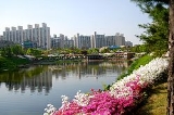
Guri is a city
in Gyeonggi Province, South Korea
. The name "Guri" is thought by some to mean "nine villages," which is reflected in the Hanja (Chinese characters; gu - nine; village - ri/li) for the town. It is located immediately to the east of Seoul, in the heart of the Capital Metropolitan Area
.
The Royal Tombs of the Joseon Dynasty
(dong-gu-reung) are located in the city. The low mountain of Achasan
is also located here, site of the Baekje
-era Acha Mountain Fortress
and numerous hiking trails. It also has pleasant walking paths along Wang-suk-cheon, a small creek separating Guri from Namyangju. The traditional town market in Toldari (Guri's downtown around what used to be a "stone bridge") provides a cheap alternative to department stores.
Guri first became a separate city in 1986. Previously, it had been considered part of Yangju
from antiquity until 1980, and part of Namyangju
from 1980 to 1986. The name "Guri" was first used in 1914, at which time it was a myeon in Yangju. Guri is connected to Seoul
via a commuter railway (Jungang Line
), as well as numerous city transit and intercity buses.
The whole area is 33.29㎢. In fact, Guri used to be bigger but some of the townships were incorporated into Seoul
and other cities surrounding Guri.
Wamgsil stream and Han river
flow into city and its tributaries are about 17.
Administrative divisions of South Korea
||South Korea is divided into 8 provinces , 1 special autonomous province , 6 metropolitan cities , and 1 special city...
in Gyeonggi Province, South Korea
South Korea
The Republic of Korea , , is a sovereign state in East Asia, located on the southern portion of the Korean Peninsula. It is neighbored by the People's Republic of China to the west, Japan to the east, North Korea to the north, and the East China Sea and Republic of China to the south...
. The name "Guri" is thought by some to mean "nine villages," which is reflected in the Hanja (Chinese characters; gu - nine; village - ri/li) for the town. It is located immediately to the east of Seoul, in the heart of the Capital Metropolitan Area
Seoul National Capital Area
The Seoul National Capital Area is a region located in the north-west of South Korea. It is generally referred to as Sudogwon in Korean, and contains three different administrative districts; Seoul, Incheon and Gyeonggi-do....
.
The Royal Tombs of the Joseon Dynasty
Royal Tombs of the Joseon Dynasty
The Royal Tombs of the Joseon Dynasty refers to the 40 tombs of members of the Korean Joseon Dynasty . These tombs are scattered in over 18 locations across South Korea. They were built to honour and respect the ancestors and their achievements, and assert their royal authority...
(dong-gu-reung) are located in the city. The low mountain of Achasan
Achasan
Achasan is a mountain that sits between the counties of Gwangjin-gu and Guri in South Korea. It has an elevation of ....
is also located here, site of the Baekje
Baekje
Baekje or Paekche was a kingdom located in southwest Korea. It was one of the Three Kingdoms of Korea, together with Goguryeo and Silla....
-era Acha Mountain Fortress
Acha Mountain Fortress
Acha Mountain Fortress is an earthen fortress of the Korean Three Kingdoms period. Originally built by Baekje, it was occupied in turn by each of the Three Kingdoms. It stands on Mount Acha, in Gwangjin-gu, Seoul, South Korea, at an altitude of 200 meters above sea level...
and numerous hiking trails. It also has pleasant walking paths along Wang-suk-cheon, a small creek separating Guri from Namyangju. The traditional town market in Toldari (Guri's downtown around what used to be a "stone bridge") provides a cheap alternative to department stores.
Guri first became a separate city in 1986. Previously, it had been considered part of Yangju
Yangju
Yangju is a city in Gyeonggi Province, South Korea. Yangju is located south of Dongducheon and north of Uijeongbu not far from Seoul.- Attractions:...
from antiquity until 1980, and part of Namyangju
Namyangju
Namyangju is a city in Gyeonggi Province, South Korea. To the east is Gapyeong County, to the west is Guri City, and to the north is Pocheon City.-History of Namyangju:...
from 1980 to 1986. The name "Guri" was first used in 1914, at which time it was a myeon in Yangju. Guri is connected to Seoul
Seoul
Seoul , officially the Seoul Special City, is the capital and largest metropolis of South Korea. A megacity with a population of over 10 million, it is the largest city proper in the OECD developed world...
via a commuter railway (Jungang Line
Jungang Line
The Jungang Line is a railway line connecting Cheongnyangni in Seoul to Gyeongju in South Korea, traversing central South Korea from the northwest to the southeast.-History:...
), as well as numerous city transit and intercity buses.
Location
It lies east-northern area of Gyeonggi province. There is Mt.Acha to the west and Namyanju city to east.The whole area is 33.29㎢. In fact, Guri used to be bigger but some of the townships were incorporated into Seoul
Seoul
Seoul , officially the Seoul Special City, is the capital and largest metropolis of South Korea. A megacity with a population of over 10 million, it is the largest city proper in the OECD developed world...
and other cities surrounding Guri.
Topography
Gwangju mountains are around the northern west area of Guri city. They are usually more than 1000m but to the exact west, there are lower hills.Wamgsil stream and Han river
Han River (Korea)
The Han River is a major river in South Korea and the fourth longest river on the Korean peninsula after the Amnok, Duman, and Nakdong rivers. It is formed by the confluence of the Namhan River , which originates in Mount Daedeok, and the Bukhan River , which originates on the slopes of Mount...
flow into city and its tributaries are about 17.
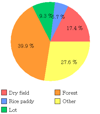
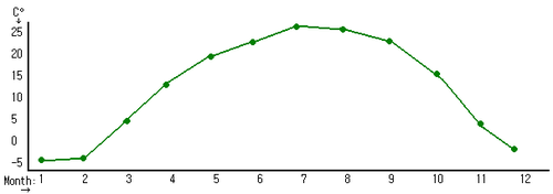
Statistics
- Land Use:
- Temperature Range:
- Miscellaneous:
Population: 170,000 Daily Deaths: 1.9 Daily Marriage: 3.1 Daily Divorce: 1.3 Fires a Day: 0.3 Students per Teacher: 25 Amount of Cars: 40,910
See also
- List of Korea-related topics
- List of cities in South Korea
- Geography of South KoreaGeography of South KoreaSouth Korea is located in East Asia, on the southern half of the Korean Peninsula jutting out from the far east of the Asian land mass. The only country with a land border to South Korea is North Korea, lying to the north with of border running along the DMZ. South Korea is mostly surrounded by...