
.gif)
Gun Hill Road (Bronx)
Encyclopedia
Gun Hill Road is a major thoroughfare in the New York City borough
of the Bronx
. The road stretches for 3.5 miles (5.63 kilometres) in Woodlawn
and Morris Park
. Gun Hill Road begins at Stillwell Avenue in Morris Park near the Hutchinson River Parkway
exit and comes to an end at the Mosholu Parkway
in Woodlawn. Van Cortlandt Park
and the Mosholu Golf Course are both located at the western terminus of Gun Hill Road.
exit 10 ramp joins at the intersection with Edson Avenue and Ely Avenue. Gun Hill Road parallels the New England Thruway until Bartow Avenue intersects, where Gun Hill moves away from the Thruway. Eastchester Road intersects soon after, which brings you to U.S. Route 1
. Between the DeWitt Place and Sexton Place intersections, the first subway station on Gun Hill Road, which is for the 5 train. Gun Hill Road intersects U.S. Route 1 as the road enters Woodlawn.
 White Plains Road
, a wide road with a median, intersects soon after. At the intersection is another subway station
, this time serving the 2 and 5 trains. West of the White Plains Road intersection, Gun Hill Road crosses over the Bronx River Parkway
at Exit 9. Northwest of there, the road passes to the south of Woodlawn Cemetery
. The intersection with DeKalb Avenue in Woodlawn will bring you to the North Central Bronx Hospital. West of the intersection with Jerome Avenue, Gun Hill Road passes to the south of the Mosholu Golf Course. Also, the road changes names from East Gun Hill Road to West Gun Hill Road. Gun Hill Road comes to its western end at the Mosholu Parkway, where it becomes a park road known as Van Cortlandt Park South.
, the road was an important artery fought between the British and the Colonists. In January 1777, the colonists brought a cannon to the top of a hill and fired at the British. The hill was called Gun Hill afterwards, and is now inside Woodlawn Cemetery
. The road was known as Kingsbridge Road (part of the original Boston Post Road
) until 1875, when it was renamed Gun Hill Road. It did not originally extend east of White Plains Road, but was extended by segments to the Hutchinson River by 1938.
In 1941, the New York City Planning Department proposed the Gun Hill Crosstown Highway as an upgrade, but nothing happened with this plan. In the mid-1960s, the Tri-State Transportation Commission proposed a new route just a mile north of Gun Hill Road called the City Line Expressway; this also got nowhere.
stations on Gun Hill Road.
Borough (New York City)
New York City, one of the largest cities in the world, is composed of five boroughs. Each borough now has the same boundaries as the county it is in. County governments were dissolved when the city consolidated in 1898, along with all city, town, and village governments within each county...
of the Bronx
The Bronx
The Bronx is the northernmost of the five boroughs of New York City. It is also known as Bronx County, the last of the 62 counties of New York State to be incorporated...
. The road stretches for 3.5 miles (5.63 kilometres) in Woodlawn
Woodlawn, Bronx
Woodlawn is a neighborhood at the very north end of the borough of the Bronx in New York City. Unlike some neighborhoods in New York City, its boundaries are fairly well-defined, as it is bounded by McLean Avenue to the north, which is approximately the New York City / Westchester County line, the...
and Morris Park
Morris Park, Bronx
Morris Park is a neighborhood in the Bronx borough of New York City . The neighborhood is part of Community Board 11 in the East Bronx. Its boundaries, starting from the north and moving clockwise are: Pelham Parkway to the north, the Amtrak Northeast Corridor tracks to the east and south, and...
. Gun Hill Road begins at Stillwell Avenue in Morris Park near the Hutchinson River Parkway
Hutchinson River Parkway
The Hutchinson River Parkway is a north–south parkway in southern New York, United States. It extends for from the massive Bruckner Interchange in the Throgs Neck section of the Bronx to the New York – Connecticut state line at Rye Brook...
exit and comes to an end at the Mosholu Parkway
Mosholu Parkway
The Mosholu Parkway is a hybrid freeway-standard parkway and grade-level roadway in the New York City borough of the Bronx, constructed from 1935 to 1937 as part of the roadway network created under Robert Moses...
in Woodlawn. Van Cortlandt Park
Van Cortlandt Park
Van Cortlandt Park is a park located in the Bronx in New York City. It is the fourth largest park in New York City, behind Pelham Bay Park, Flushing Meadows Park and Staten Island Greenbelt....
and the Mosholu Golf Course are both located at the western terminus of Gun Hill Road.
Street description
The east end of Gun Hill Road is at an intersection with Exit 4S of the Hutchinson River Parkway and Stillwell Avenue. The road for about .2 of a mile is one-way, and intersects with Waring Avenue. The New England ThruwayNew England Thruway
The New England Thruway is a portion of the U.S. Interstate highway system and of the New York State Thruway, within and operated by the New York State Thruway Authority, linking New York City with New England, specifically with southwestern Connecticut...
exit 10 ramp joins at the intersection with Edson Avenue and Ely Avenue. Gun Hill Road parallels the New England Thruway until Bartow Avenue intersects, where Gun Hill moves away from the Thruway. Eastchester Road intersects soon after, which brings you to U.S. Route 1
U.S. Route 1 in New York
U.S. Route 1 is a part of the U.S. Highway System that runs from Key West, Florida, to the Canada – United States border at Fort Kent, Maine. In the U.S. state of New York, US 1 extends from the George Washington Bridge in Manhattan to the Connecticut state line at Port Chester...
. Between the DeWitt Place and Sexton Place intersections, the first subway station on Gun Hill Road, which is for the 5 train. Gun Hill Road intersects U.S. Route 1 as the road enters Woodlawn.
White Plains Road
White Plains Road is a major thoroughfare which runs the length of the Bronx, New York, from Castle Hill and Clason Point in the south to Wakefield in the north, where it crosses the city line and becomes West 1st Street of Mount Vernon, New York. The Bronx River Parkway lies to its west and...
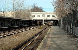
, a wide road with a median, intersects soon after. At the intersection is another subway station
Gun Hill Road (IRT White Plains Road Line)
Gun Hill Road is an express station on the IRT White Plains Road Line of the New York City Subway. Located in the Bronx at the intersection of Gun Hill and White Plains Roads, it is served by the 2 train at all times while the 5 train provides additional rush hour service in the peak direction.This...
, this time serving the 2 and 5 trains. West of the White Plains Road intersection, Gun Hill Road crosses over the Bronx River Parkway
Bronx River Parkway
The Bronx River Parkway is a long parkway in downstate New York. It is named for the nearby Bronx River, which it parallels. The southern terminus of the parkway is at Story Avenue near Bruckner Expressway in the Bronx neighborhood of Soundview...
at Exit 9. Northwest of there, the road passes to the south of Woodlawn Cemetery
Woodlawn Cemetery, Bronx
Woodlawn Cemetery is one of the largest cemeteries in New York City and is a designated National Historic Landmark.A rural cemetery located in the Bronx, it opened in 1863, in what was then southern Westchester County, in an area that was annexed to New York City in 1874.The cemetery covers more...
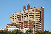
. The intersection with DeKalb Avenue in Woodlawn will bring you to the North Central Bronx Hospital. West of the intersection with Jerome Avenue, Gun Hill Road passes to the south of the Mosholu Golf Course. Also, the road changes names from East Gun Hill Road to West Gun Hill Road. Gun Hill Road comes to its western end at the Mosholu Parkway, where it becomes a park road known as Van Cortlandt Park South.
History
During the RevolutionAmerican Revolution
The American Revolution was the political upheaval during the last half of the 18th century in which thirteen colonies in North America joined together to break free from the British Empire, combining to become the United States of America...
, the road was an important artery fought between the British and the Colonists. In January 1777, the colonists brought a cannon to the top of a hill and fired at the British. The hill was called Gun Hill afterwards, and is now inside Woodlawn Cemetery
Woodlawn Cemetery, Bronx
Woodlawn Cemetery is one of the largest cemeteries in New York City and is a designated National Historic Landmark.A rural cemetery located in the Bronx, it opened in 1863, in what was then southern Westchester County, in an area that was annexed to New York City in 1874.The cemetery covers more...
. The road was known as Kingsbridge Road (part of the original Boston Post Road
Boston Post Road
The Boston Post Road was a system of mail-delivery routes between New York City and Boston, Massachusetts that evolved into the first major highways in the United States.The three major alignments were the Lower Post Road The Boston Post Road was a system of mail-delivery routes between New York...
) until 1875, when it was renamed Gun Hill Road. It did not originally extend east of White Plains Road, but was extended by segments to the Hutchinson River by 1938.
In 1941, the New York City Planning Department proposed the Gun Hill Crosstown Highway as an upgrade, but nothing happened with this plan. In the mid-1960s, the Tri-State Transportation Commission proposed a new route just a mile north of Gun Hill Road called the City Line Expressway; this also got nowhere.
Transportation
Subway
There are two New York City SubwayNew York City Subway
The New York City Subway is a rapid transit system owned by the City of New York and leased to the New York City Transit Authority, a subsidiary agency of the Metropolitan Transportation Authority and also known as MTA New York City Transit...
stations on Gun Hill Road.
- Gun Hill RoadGun Hill Road (IRT White Plains Road Line)Gun Hill Road is an express station on the IRT White Plains Road Line of the New York City Subway. Located in the Bronx at the intersection of Gun Hill and White Plains Roads, it is served by the 2 train at all times while the 5 train provides additional rush hour service in the peak direction.This...
on the IRT White Plains Road LineIRT White Plains Road LineThe White Plains Road Line is a rapid transit line of the IRT division of the New York City Subway, serving the central Bronx. It is mostly elevated, and served both subway and elevated trains until 1952...
serves the trains - Gun Hill RoadGun Hill Road (IRT Dyre Avenue Line)Gun Hill Road is a station on the IRT Dyre Avenue Line of the New York City Subway, located at the intersection of Gun Hill Road and Seymour Avenue in the Baychester and Allerton sections of The Bronx...
on the IRT Dyre Avenue LineIRT Dyre Avenue LineThe IRT Dyre Avenue Line is a New York City Subway rapid transit line as part of the A Division . It is a branch of the IRT White Plains Road Line serving passengers in the northeastern section of the Bronx...
serves the train
Bus
There are several buses that travel on Gun Hill Road. They include the Bx28, Bx30, Bx39 (not directly), Bx41, and the Bx55.Major intersections
See also
- Gun Hill Road (IRT White Plains Road Line)Gun Hill Road (IRT White Plains Road Line)Gun Hill Road is an express station on the IRT White Plains Road Line of the New York City Subway. Located in the Bronx at the intersection of Gun Hill and White Plains Roads, it is served by the 2 train at all times while the 5 train provides additional rush hour service in the peak direction.This...
- Gun Hill Road (IRT Dyre Avenue Line)Gun Hill Road (IRT Dyre Avenue Line)Gun Hill Road is a station on the IRT Dyre Avenue Line of the New York City Subway, located at the intersection of Gun Hill Road and Seymour Avenue in the Baychester and Allerton sections of The Bronx...
- Williams Bridge (Metro-North station)Williams Bridge (Metro-North station)The Williams Bridge Metro-North Railroad station serves the residents of the Williamsbridge section of The Bronx via the Harlem Line. It is 10.5 miles from Grand Central Terminal and is located at the intersection of Gun Hill Road and Webster Avenue. Service at Williams Bridge is hourly...