
Gumeracha, South Australia
Encyclopedia
Gumeracha is a town near Adelaide
, South Australia
, located on the Adelaide-Mannum Road
. It is located in the Adelaide Hills Council
local government area. At the 2006 census
, Gumeracha had a population of 731.
took up a parcel of land, on which the settlements of Gumeracha, Kenton Valley and Forreston
developed. The Company established a district headquarters and opened it up for sheep grazing.
In 1839, William Beavis Randell built his home, Tinmath, at Kenton Park and built a flour mill in the 1840s. The estate housed his large family, his workforce and their families. In 1846, Randell donated land and funds for a church, and the Salem Baptist Church was built - the oldest Baptist church still in use in South Australia. The surrounding area, meanwhile, had become an agricultural centre, and the Gumeracha Farmers' Society held annual shows.
In 1855, Randell allocated land for a township and by 1860 the town was laid out. Commercial businesses sprang up on the main street (Victoria Street), and many fine buildings were erected, including the Post Office, Police Station & Court House (1864), Institute Hall, Town Hall (1909), a butter factory (1889), a school, a hospital, a coach-house, hotels, churches and business houses. Most of the buildings in use at this time still stand today. William Beavis Randell's son, William Richard Randell
, would build the first River Murray paddlesteamer in Gumeracha in 1852.
The region relies heavily on grazing, dairying and market gardening.
and Birdwood
along the Adelaide-Mannum Road
, and north of Lobethal
along the Gumeracha-Lobethal Road.
At the ABS
2001 census, Gumeracha had a population of 599 people living in 266 dwellings.
 Gumeracha is the regional centre for the area. It contains a primary school, hospital, community centre, sports facilities and council offices of the Adelaide Hills Council
(the main office is at Woodside
). There is also a golf course in Kenton Valley south of the town.
Several wineries, including Chain of Ponds Wines and Talunga Premium Wines, operate in Gumeracha and in nearby areas.
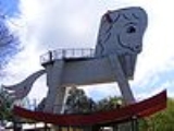
The most notable attraction of Gumeracha is the "biggest rocking horse in the world
" - standing at 18.3 metres (60 ft) (approximately the height of a six-storey building), it is just east of the town on Main Road and serves to advertise the toy factory and wildlife park.
to Gumeracha and Mount Pleasant
by LinkSA.
Adelaide
Adelaide is the capital city of South Australia and the fifth-largest city in Australia. Adelaide has an estimated population of more than 1.2 million...
, South Australia
South Australia
South Australia is a state of Australia in the southern central part of the country. It covers some of the most arid parts of the continent; with a total land area of , it is the fourth largest of Australia's six states and two territories.South Australia shares borders with all of the mainland...
, located on the Adelaide-Mannum Road
Adelaide-Mannum Road
Adelaide–Mannum Road is a road that runs through the northern Adelaide Hills between the South Australian capital, Adelaide and Mannum on the Murray River. It is designated State Highway A10 in the metropolitan area and B10 in rural areas, and is 77 kilometres in length. It is named after the two...
. It is located in the Adelaide Hills Council
Adelaide Hills Council
Adelaide Hills Council was established in 1997 by the amalgamation of four smaller district councils...
local government area. At the 2006 census
Census in Australia
The Australian census is administered once every five years by the Australian Bureau of Statistics. The most recent census was conducted on 9 August 2011; the next will be conducted in 2016. Prior to the introduction of regular censuses in 1961, they had also been run in 1901, 1911, 1921, 1933,...
, Gumeracha had a population of 731.
History
Gumeracha is one of South Australia's oldest settled areas. In 1839, the South Australia CompanySouth Australia Company
The South Australian Company was formed in London on 9 October 1835 by George Fife Angas and other wealthy British merchants to develop a new settlement in South Australia; its purpose was to build a new colony...
took up a parcel of land, on which the settlements of Gumeracha, Kenton Valley and Forreston
Forreston, South Australia
Forreston is a locality near Adelaide, South Australia. It is located in the Adelaide Hills Council local government area 3 km northeast of Gumeracha.-History:...
developed. The Company established a district headquarters and opened it up for sheep grazing.
In 1839, William Beavis Randell built his home, Tinmath, at Kenton Park and built a flour mill in the 1840s. The estate housed his large family, his workforce and their families. In 1846, Randell donated land and funds for a church, and the Salem Baptist Church was built - the oldest Baptist church still in use in South Australia. The surrounding area, meanwhile, had become an agricultural centre, and the Gumeracha Farmers' Society held annual shows.
In 1855, Randell allocated land for a township and by 1860 the town was laid out. Commercial businesses sprang up on the main street (Victoria Street), and many fine buildings were erected, including the Post Office, Police Station & Court House (1864), Institute Hall, Town Hall (1909), a butter factory (1889), a school, a hospital, a coach-house, hotels, churches and business houses. Most of the buildings in use at this time still stand today. William Beavis Randell's son, William Richard Randell
William Randell
William Richard Randell "Captain Randell" , was an Australian politician and pioneer born in Devon, England, who emigrated to the newly-founded colony of South Australia in 1837 with his family...
, would build the first River Murray paddlesteamer in Gumeracha in 1852.
The region relies heavily on grazing, dairying and market gardening.
Geography
Gumeracha is located between InglewoodInglewood, South Australia
Inglewood is a small town near Adelaide, South Australia. It is located in the Adelaide Hills Council local government area, and is adjacent to Houghton, Paracombe and the rural districts of Upper Hermitage and Chain Of Ponds...
and Birdwood
Birdwood, South Australia
Birdwood is a town near Adelaide, South Australia. It is located in the Adelaide Hills Council local government area.- Origin of the name :Formerly known as Blumberg, the German town name was anglicized during World War I, along with many others in the region in 1917...
along the Adelaide-Mannum Road
Adelaide-Mannum Road
Adelaide–Mannum Road is a road that runs through the northern Adelaide Hills between the South Australian capital, Adelaide and Mannum on the Murray River. It is designated State Highway A10 in the metropolitan area and B10 in rural areas, and is 77 kilometres in length. It is named after the two...
, and north of Lobethal
Lobethal, South Australia
Lobethal is a town in the Adelaide Hills area of South Australia. It is located in the Adelaide Hills Council local government area, and is nestled on the banks of a creek between the hills and up the sides of the valley. It was once the centre of the Adelaide Hills wool processing industry, which...
along the Gumeracha-Lobethal Road.
At the ABS
Australian Bureau of Statistics
The Australian Bureau of Statistics is Australia's national statistical agency. It was created as the Commonwealth Bureau of Census and Statistics on 8 December 1905, when the Census and Statistics Act 1905 was given Royal assent. It had its beginnings in section 51 of the Constitution of Australia...
2001 census, Gumeracha had a population of 599 people living in 266 dwellings.
Facilities
Adelaide Hills Council
Adelaide Hills Council was established in 1997 by the amalgamation of four smaller district councils...
(the main office is at Woodside
Woodside, South Australia
Woodside is a town in the Adelaide Hills region of South Australia. The town is between Balhannah and Lobethal, from the state capital, Adelaide. Amenities include a swimming pool, , second hand store, grocery store, tennis club, bowls club and playing fields. The Johnston family of Oakbank...
). There is also a golf course in Kenton Valley south of the town.
Several wineries, including Chain of Ponds Wines and Talunga Premium Wines, operate in Gumeracha and in nearby areas.
The most notable attraction of Gumeracha is the "biggest rocking horse in the world
Big Rocking horse
The Big Rocking Horse is a tourist attraction located in the town of Gumeracha, South Australia. Designed by David McIntosh, the structure weighs 25 tonnes and stands at over 18 metres tall, and is one of a number of Big Things in Australia designed to attract the attention of passing motorists...
" - standing at 18.3 metres (60 ft) (approximately the height of a six-storey building), it is just east of the town on Main Road and serves to advertise the toy factory and wildlife park.
Transport
The area is not serviced by Adelaide public transport. A coach is operated from Tea Tree Plaza InterchangeTea Tree Plaza Interchange
Tea Tree Plaza Interchange is an interchange belonging to the Adelaide Metro. It is the terminating station of the O-Bahn Busway, and is a central public transport hub for the north eastern suburbs of Adelaide, South Australia.The interchange is also a popular hangout for students from the nearby...
to Gumeracha and Mount Pleasant
Mount Pleasant, South Australia
Mount Pleasant is a town situated at the northern end of the Adelaide Hills region of South Australia, 55 kilometres east-north-east of the state capital, Adelaide . It is located in the Barossa Council and Mid Murray Council local government areas, and is at an altitude of 440 metres above sea level...
by LinkSA.