

Guayama metropolitan area
Encyclopedia
United States Census Bureau
The United States Census Bureau is the government agency that is responsible for the United States Census. It also gathers other national demographic and economic data...
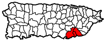
defined Metropolitan Statistical Area (MSA) in southeastern Puerto Rico
Puerto Rico
Puerto Rico , officially the Commonwealth of Puerto Rico , is an unincorporated territory of the United States, located in the northeastern Caribbean, east of the Dominican Republic and west of both the United States Virgin Islands and the British Virgin Islands.Puerto Rico comprises an...
. 2010 Census results placed the population at 84,214, a 0.83% increase over the 2000 census
United States Census, 2000
The Twenty-second United States Census, known as Census 2000 and conducted by the Census Bureau, determined the resident population of the United States on April 1, 2000, to be 281,421,906, an increase of 13.2% over the 248,709,873 persons enumerated during the 1990 Census...
figure of 83,570.
Municipalities
A total of three municipalities (SpanishSpanish language
Spanish , also known as Castilian , is a Romance language in the Ibero-Romance group that evolved from several languages and dialects in central-northern Iberia around the 9th century and gradually spread with the expansion of the Kingdom of Castile into central and southern Iberia during the...
: municipios) are included as part of the Guayama Metropolitan Statistical Area. They are:
- ArroyoArroyo, Puerto RicoArroyo is a municipality located along the southern coast of Puerto Rico and bordered by the Caribbean Sea, east of the municipality of Guayama and northwest of the municipality of Patillas. Arroyo is spread over 5 wards and Arroyo Pueblo...
- GuayamaGuayama, Puerto RicoGuayama is a municipality of Puerto Rico founded on January 29, 1736 and located on the Southern Coastal Valley region, bordering the Caribbean, south of Cayey; east of Salinas; and west of Patillas and Arroyo. Guayama is spread over 9 wards and Guayama Pueblo...
--Principal City - PatillasPatillas, Puerto RicoPatillas is a municipality of Puerto Rico located in the southeastern coast, south of San Lorenzo; west of Yabucoa and Maunabo; and east of Guayama and Arroyo. It is spread over 15 wards and Patillas Pueblo...