

Grossetto Airport
Encyclopedia
Grosseto Airport is an airport in central Italy
, located 3 km (3,000,000,000,000 nm) west of Grosseto
in the Italian
region of Tuscany
.
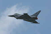 Although it is classified as a "joint use" facility, Grosseto Air Base is primarily an Italian Air Force
(Aeronautica Militare
) Base, home of the 4th Stormo, equipped with the Eurofighter Typhoon
. However, the facility is used as a commercial airport by civilian charter flights and private aircraft.
the airfield was used by the United States Army Air Force Twelfth Air Force. The 86th Fighter Group flew P-47 Thunderbolt
s from the field between 17 September and 6 November 1944. Later, the 57th Fighter Group, used the airfield from 24 September 1944 to 29 April 1945, and later between 7 May and 15 July 1945, flying combat operations with P-40 Warhawks.
of 15 feet (5 m) above mean sea level. It has two asphalt
paved runway
s: 03L/21R measuring 2994 by 45 m (9,822.8 by 147.6 ) and 03R/21L measuring 2356 by 24 m (7,729.7 by 78.7 ).
Italy
Italy , officially the Italian Republic languages]] under the European Charter for Regional or Minority Languages. In each of these, Italy's official name is as follows:;;;;;;;;), is a unitary parliamentary republic in South-Central Europe. To the north it borders France, Switzerland, Austria and...
, located 3 km (3,000,000,000,000 nm) west of Grosseto
Grosseto
Grosseto is a city and comune in the central Italian region of Tuscany, the capital of the Province of Grosseto. The city lies 14 km from the Tyrrhenian Sea, in the Maremma, at the centre of an alluvial plain, on the Ombrone river....
in the Italian
Italy
Italy , officially the Italian Republic languages]] under the European Charter for Regional or Minority Languages. In each of these, Italy's official name is as follows:;;;;;;;;), is a unitary parliamentary republic in South-Central Europe. To the north it borders France, Switzerland, Austria and...
region of Tuscany
Tuscany
Tuscany is a region in Italy. It has an area of about 23,000 square kilometres and a population of about 3.75 million inhabitants. The regional capital is Florence ....
.
Italian Air Force
The Italian Air Force has gone under different names in different periods:*Regia Aeronautica , from 1923 to June 1946*Aeronautica Nazionale Repubblicana, the air force of Italian Social Republic during World War II...
(Aeronautica Militare
Aeronautica Militare
The Italian Air Force is the air force of the Italian Republic. It has held a prominent role in modern Italian military history...
) Base, home of the 4th Stormo, equipped with the Eurofighter Typhoon
Eurofighter Typhoon
The Eurofighter Typhoon is a twin-engine, canard-delta wing, multirole combat aircraft, designed and built by a consortium of three companies: EADS, Alenia Aeronautica and BAE Systems; working through a holding company, Eurofighter GmbH, which was formed in 1986...
. However, the facility is used as a commercial airport by civilian charter flights and private aircraft.
History
During World War IIWorld War II
World War II, or the Second World War , was a global conflict lasting from 1939 to 1945, involving most of the world's nations—including all of the great powers—eventually forming two opposing military alliances: the Allies and the Axis...
the airfield was used by the United States Army Air Force Twelfth Air Force. The 86th Fighter Group flew P-47 Thunderbolt
P-47 Thunderbolt
Republic Aviation's P-47 Thunderbolt, also known as the "Jug", was the largest, heaviest, and most expensive fighter aircraft in history to be powered by a single reciprocating engine. It was heavily armed with eight .50-caliber machine guns, four per wing. When fully loaded, the P-47 weighed up to...
s from the field between 17 September and 6 November 1944. Later, the 57th Fighter Group, used the airfield from 24 September 1944 to 29 April 1945, and later between 7 May and 15 July 1945, flying combat operations with P-40 Warhawks.
Facilities
The airport resides at an elevationElevation
The elevation of a geographic location is its height above a fixed reference point, most commonly a reference geoid, a mathematical model of the Earth's sea level as an equipotential gravitational surface ....
of 15 feet (5 m) above mean sea level. It has two asphalt
Asphalt
Asphalt or , also known as bitumen, is a sticky, black and highly viscous liquid or semi-solid that is present in most crude petroleums and in some natural deposits, it is a substance classed as a pitch...
paved runway
Runway
According to ICAO a runway is a "defined rectangular area on a land aerodrome prepared for the landing and take-off of aircraft." Runways may be a man-made surface or a natural surface .- Orientation and dimensions :Runways are named by a number between 01 and 36, which is generally one tenth...
s: 03L/21R measuring 2994 by 45 m (9,822.8 by 147.6 ) and 03R/21L measuring 2356 by 24 m (7,729.7 by 78.7 ).