

Groom, Texas
Encyclopedia
Groom is a town in Carson County
, Texas
, United States
. The population was 587 at the 2000 census. It is part of the Amarillo, Texas
Metropolitan Statistical Area
. It is on Interstate Highway 40 (Historic Route 66) 42 miles east of Amarillo
, 220 miles (354.1 km) west of Oklahoma City
.
According to the United States Census Bureau
, the town has a total area of 0.8 square miles (2.1 km²), all of it land.
of 2000, there were 587 people, 240 households, and 178 families residing in the town. The population density
was 778.7 people per square mile (302.2/km²). There were 290 housing units at an average density of 384.7 per square mile (149.3/km²). The racial makeup of the town was 94.72% White, 0.17% Native American, 0.17% Asian, 2.90% from other races
, and 2.04% from two or more races. Hispanic or Latino of any race were 4.77% of the population.
There were 240 households out of which 31.3% had children under the age of 18 living with them, 63.3% were married couples
living together, 7.5% had a female householder with no husband present, and 25.8% were non-families. 25.8% of all households were made up of individuals and 16.3% had someone living alone who was 65 years of age or older. The average household size was 2.45 and the average family size was 2.92.
In the town the population was spread out with 26.6% under the age of 18, 6.8% from 18 to 24, 23.9% from 25 to 44, 22.0% from 45 to 64, and 20.8% who were 65 years of age or older. The median age was 40 years. For every 100 females there were 95.0 males. For every 100 females age 18 and over, there were 93.3 males.
The median income for a household in the town was $31,705, and the median income for a family was $39,063. Males had a median income of $30,577 versus $24,500 for females. The per capita income
for the town was $15,593. About 9.4% of families and 13.2% of the population were below the poverty line, including 22.0% of those under age 18 and 11.8% of those age 65 or over.
. Inspired by this cross, residents of Effingham, Illinois
erected a similar cross that is eight feet taller. Many claim this cross to be the largest in the Western Hemisphere. However, it is smaller than the cross erected in the Valle de los Caidos in Spain, located at 40°38′29"N 04°09′26"W and elevated 152.4 m overground. The cross is also 18 feet (5.5 m) shorter than the 208 ft (63.4 m) cross at the Mission Nombre De Dios
in St. Augustine, Florida
, and shorter than the 65 metres (213.3 ft) tall Lakeuden Risti cross-shaped church tower in Seinäjoki
, Finland
. The movie Leap of Faith
was filmed on location near the site of the cross in Groom but the movie was filmed before the cross was built.
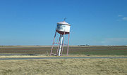 Also in Groom one can find a leaning water tower
which currently serves as a decorative item. It originally was a functioning water tower which was slated for demolition until Ralph Britten bought it and moved it to serve as a sign for his truck stop and tourist information center (located on a stretch of interstate that was once a part of U.S. Route 66
). This truck stop can still be seen, set back off the road behind the tower, now boarded up and in disrepair following a devastating fire decades ago.
The leaning water tower still remains a popular target for cameras, and the town of Groom turns on a large colored star mounted on the top around Christmas time. The water tower is a common image from Route 66 photography books.
Carson County, Texas
Carson County is a county located in the U.S. state of Texas. It is part of the Amarillo metropolitan area. In 2000, its population was 6,516. Carson is named for Samuel Price Carson, the first secretary of state of the Republic of Texas. The seat of the county is Panhandle. It was founded in...
, Texas
Texas
Texas is the second largest U.S. state by both area and population, and the largest state by area in the contiguous United States.The name, based on the Caddo word "Tejas" meaning "friends" or "allies", was applied by the Spanish to the Caddo themselves and to the region of their settlement in...
, United States
United States
The United States of America is a federal constitutional republic comprising fifty states and a federal district...
. The population was 587 at the 2000 census. It is part of the Amarillo, Texas
Amarillo, Texas
Amarillo is the 14th-largest city, by population, in the state of Texas, the largest in the Texas Panhandle, and the seat of Potter County. A portion of the city extends into Randall County. The population was 190,695 at the 2010 census...
Metropolitan Statistical Area
Amarillo metropolitan area
The Amarillo Metropolitan Statistical Area is a metropolitan area in the Texas Panhandle that covers four counties - Armstrong, Carson, Potter, and Randall...
. It is on Interstate Highway 40 (Historic Route 66) 42 miles east of Amarillo
Amarillo, Texas
Amarillo is the 14th-largest city, by population, in the state of Texas, the largest in the Texas Panhandle, and the seat of Potter County. A portion of the city extends into Randall County. The population was 190,695 at the 2010 census...
, 220 miles (354.1 km) west of Oklahoma City
Oklahoma City, Oklahoma
Oklahoma City is the capital and the largest city in the state of Oklahoma. The county seat of Oklahoma County, the city ranks 31st among United States cities in population. The city's population, from the 2010 census, was 579,999, with a metro-area population of 1,252,987 . In 2010, the Oklahoma...
.
Geography
Groom is located at 35°12′11"N 101°6′24"W (35.203112, -101.106710).According to the United States Census Bureau
United States Census Bureau
The United States Census Bureau is the government agency that is responsible for the United States Census. It also gathers other national demographic and economic data...
, the town has a total area of 0.8 square miles (2.1 km²), all of it land.
Demographics
As of the censusCensus
A census is the procedure of systematically acquiring and recording information about the members of a given population. It is a regularly occurring and official count of a particular population. The term is used mostly in connection with national population and housing censuses; other common...
of 2000, there were 587 people, 240 households, and 178 families residing in the town. The population density
Population density
Population density is a measurement of population per unit area or unit volume. It is frequently applied to living organisms, and particularly to humans...
was 778.7 people per square mile (302.2/km²). There were 290 housing units at an average density of 384.7 per square mile (149.3/km²). The racial makeup of the town was 94.72% White, 0.17% Native American, 0.17% Asian, 2.90% from other races
Race (United States Census)
Race and ethnicity in the United States Census, as defined by the Federal Office of Management and Budget and the United States Census Bureau, are self-identification data items in which residents choose the race or races with which they most closely identify, and indicate whether or not they are...
, and 2.04% from two or more races. Hispanic or Latino of any race were 4.77% of the population.
There were 240 households out of which 31.3% had children under the age of 18 living with them, 63.3% were married couples
Marriage
Marriage is a social union or legal contract between people that creates kinship. It is an institution in which interpersonal relationships, usually intimate and sexual, are acknowledged in a variety of ways, depending on the culture or subculture in which it is found...
living together, 7.5% had a female householder with no husband present, and 25.8% were non-families. 25.8% of all households were made up of individuals and 16.3% had someone living alone who was 65 years of age or older. The average household size was 2.45 and the average family size was 2.92.
In the town the population was spread out with 26.6% under the age of 18, 6.8% from 18 to 24, 23.9% from 25 to 44, 22.0% from 45 to 64, and 20.8% who were 65 years of age or older. The median age was 40 years. For every 100 females there were 95.0 males. For every 100 females age 18 and over, there were 93.3 males.
The median income for a household in the town was $31,705, and the median income for a family was $39,063. Males had a median income of $30,577 versus $24,500 for females. The per capita income
Per capita income
Per capita income or income per person is a measure of mean income within an economic aggregate, such as a country or city. It is calculated by taking a measure of all sources of income in the aggregate and dividing it by the total population...
for the town was $15,593. About 9.4% of families and 13.2% of the population were below the poverty line, including 22.0% of those under age 18 and 11.8% of those age 65 or over.
Giant Cross
There is a 19-story cross located next to Interstate 40 (formerly U.S. Route 66) at Groom. This 190 feet (57.9 m) tall free-standing cross can be seen from twenty miles (32 km) away. Surrounding the base of the cross are life-sized statues of the Stations of the CrossStations of the Cross
Stations of the Cross refers to the depiction of the final hours of Jesus, and the devotion commemorating the Passion. The tradition as chapel devotion began with St...
. Inspired by this cross, residents of Effingham, Illinois
Effingham, Illinois
Effingham is a city in Effingham County, Illinois, United States. The population was 12,384 at the 2000 census. It is the county seat of Effingham County....
erected a similar cross that is eight feet taller. Many claim this cross to be the largest in the Western Hemisphere. However, it is smaller than the cross erected in the Valle de los Caidos in Spain, located at 40°38′29"N 04°09′26"W and elevated 152.4 m overground. The cross is also 18 feet (5.5 m) shorter than the 208 ft (63.4 m) cross at the Mission Nombre De Dios
Nombre de Dios (mission)
Nombre de Dios is a Spanish Catholic mission in St. Augustine, Florida, United States. The mission traces its origins to September 1565, when Admiral Pedro Menéndez de Avilés founded the city of St. Augustine. A formal Franciscan mission was founded near the city in 1587, perhaps the first mission...
in St. Augustine, Florida
St. Augustine, Florida
St. Augustine is a city in the northeast section of Florida and the county seat of St. Johns County, Florida, United States. Founded in 1565 by Spanish explorer and admiral Pedro Menéndez de Avilés, it is the oldest continuously occupied European-established city and port in the continental United...
, and shorter than the 65 metres (213.3 ft) tall Lakeuden Risti cross-shaped church tower in Seinäjoki
Seinäjoki
Seinäjoki is a city located in Southern Ostrobothnia, Finland. Seinäjoki originated around the Östermyra bruk iron and gunpowder factories founded in 1798. Seinäjoki became a municipality in 1868, market town in 1931 and town in 1960...
, Finland
Finland
Finland , officially the Republic of Finland, is a Nordic country situated in the Fennoscandian region of Northern Europe. It is bordered by Sweden in the west, Norway in the north and Russia in the east, while Estonia lies to its south across the Gulf of Finland.Around 5.4 million people reside...
. The movie Leap of Faith
Leap of Faith (film)
Leap of Faith is a 1992 American dramedy film, directed by Richard Pearce and starring Steve Martin, Liam Neeson and Debra Winger. The film is about Jonas Nightengale, a fraudulent Christian faith healer who uses his revival meetings, in Rustwater, Kansas, to bilk believers out of their money.-Plot...
was filmed on location near the site of the cross in Groom but the movie was filmed before the cross was built.
Leaning Water Tower
Water tower
A water tower or elevated water tower is a large elevated drinking water storage container constructed to hold a water supply at a height sufficient to pressurize a water distribution system....
which currently serves as a decorative item. It originally was a functioning water tower which was slated for demolition until Ralph Britten bought it and moved it to serve as a sign for his truck stop and tourist information center (located on a stretch of interstate that was once a part of U.S. Route 66
U.S. Route 66
U.S. Route 66 was a highway within the U.S. Highway System. One of the original U.S. highways, Route 66 was established on November 11, 1926 -- with road signs erected the following year...
). This truck stop can still be seen, set back off the road behind the tower, now boarded up and in disrepair following a devastating fire decades ago.
The leaning water tower still remains a popular target for cameras, and the town of Groom turns on a large colored star mounted on the top around Christmas time. The water tower is a common image from Route 66 photography books.