

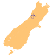
Grey River
Encyclopedia
South Island
The South Island is the larger of the two major islands of New Zealand, the other being the more populous North Island. It is bordered to the north by Cook Strait, to the west by the Tasman Sea, to the south and east by the Pacific Ocean...
of New Zealand
New Zealand
New Zealand is an island country in the south-western Pacific Ocean comprising two main landmasses and numerous smaller islands. The country is situated some east of Australia across the Tasman Sea, and roughly south of the Pacific island nations of New Caledonia, Fiji, and Tonga...
. It rises in Lake Christabel
Lake Christabel
Lake Christabel is a small lake in the north of New Zealand's South Island. It is located 12 kilometres southwest of the Lewis Pass. The lake is the source of the Grey River, one of the longest rivers on the South Island's West Coast, although its outlet is underground. The lake lies behind a...
, one of numerous small lakes on the western side of the Southern Alps
Southern Alps
The Southern Alps is a mountain range extending along much of the length of New Zealand's South Island, reaching its greatest elevations near the island's western side...
,12 kilometres southwest of the Lewis Pass
Lewis Pass
Lewis Pass is a mountain pass in the South Island of New Zealand.The northernmost of the three main passes across the Southern Alps, it is higher than the Haast Pass, but slightly lower than Arthur's Pass...
, and runs westward for 120 kilometres before draining into the Tasman Sea
Tasman Sea
The Tasman Sea is the large body of water between Australia and New Zealand, approximately across. It extends 2,800 km from north to south. It is a south-western segment of the South Pacific Ocean. The sea was named after the Dutch explorer Abel Janszoon Tasman, the first recorded European...
at Greymouth
Greymouth
Greymouth is the largest town in the West Coast region in the South Island of New Zealand, and the seat of the Grey District Council. The population of the whole Grey District is , which accounts for % of the West Coast's inhabitants...
. The river was named by explorer Thomas Brunner
Thomas Brunner
Thomas Brunner was an English-born surveyor and explorer remembered for his exploration of the western coastal areas of New Zealand's South Island....
in honour of New Zealand politician Sir George Grey
George Edward Grey
Sir George Grey, KCB was a soldier, explorer, Governor of South Australia, twice Governor of New Zealand, Governor of Cape Colony , the 11th Premier of New Zealand and a writer.-Early life and exploration:...
. The official name of the river was changed to Grey River / Māwheranui in 1998 by way of the Ngai Tahu Claims Settlement Act 1998 The Maori
Maori language
Māori or te reo Māori , commonly te reo , is the language of the indigenous population of New Zealand, the Māori. It has the status of an official language in New Zealand...
name for the river system and surrounding area is Māwhera, with Māwheranui being distinguished from the northern brach Little Grey River / Māwheraiti.
Numerous small rivers are tributaries of the Grey, and several of them also drain lakes. Notable among these are the Ahaura River
Ahaura River
The Ahaura River is in the South Island of New Zealand. This river drains the western flanks of the Southern Alps and flows into the Grey River....
and the Arnold River
Arnold River, New Zealand
The Arnold River is located in the west of New Zealand's South Island. It is the outflow of Lake Brunner, which it links with the Grey River. The Arnold River flows northwest for 20 kilometres, joining the Grey immediately above the town of Brunner, some 15 kilometres from the Tasman Sea...
, the latter of which is the outflow of Lake Brunner
Lake Brunner
Lake Brunner is the largest lake in the northwestern South Island of New Zealand, covering an area of 40 km². The lake's outflow is the Arnold River, a tributary of the Grey River. The lake lies 31 kilometres to the southeast of Greymouth...
, the largest lake of the northwest South Island. A small hydroelectric
Hydroelectricity
Hydroelectricity is the term referring to electricity generated by hydropower; the production of electrical power through the use of the gravitational force of falling or flowing water. It is the most widely used form of renewable energy...
station is located on the river 25 kilometres upstream from the mouth of the river.
The Grey River's mouth is protected by a large sandbar, Greymouth bar, which is a notorious danger to shipping.