
Grayville, Illinois
Encyclopedia
Grayville is a city in Edwards
and White
counties in Illinois
. The population was 1,725 at the 2000 census. Grayville is the birthplace of naval hero James Meredith Helm
.
According to the United States Census Bureau
, the city has a total area of 1.5 square miles (3.9 km²), of which, 1.5 square miles (3.9 km²) of it is land and 0.04 square mile (0.1035995244 km²) of it (2.61%) is water.
meets Illinois Route 1
, and Route 1 meets Interstate 64
.
Grayville was built on the Wabash River
and, while it is no longer on any major rail line, it formerly was home to a large rail bridge across the Wabash into Indiana
, but sections of that bridge collapsed in January 2005 due to a major flood
of the Wabash River.
In late 2005, an ethanol
plant was proposed for the Grayville area, and the construction of the plant would have included rebuilding the bridge and rail lines leading to it on both the Indiana and Illinois sides of the river, but as of July 2009, neither the plant nor the bridge have been built.
The largest bridge to Indiana
south of Lawrenceville
, and the only Interstate
link between Illinois and Indiana south of Terre Haute, the I-64 river crossing runs parallel to the collapsed rail bridge, just a few dozen yards upstream.
of 2000, there were 1,725 people, 754 households, and 478 families residing in the city. The population density
was 1,158.2 people per square mile (447.0/km²). There were 833 housing units at an average density of 559.3 per square mile (215.9/km²). The racial makeup of the city was 98.67% White, 0.12% African American, 0.12% Native American, 0.12% Asian, 0.17% Pacific Islander, 0.17% from other races
, and 0.64% from two or more races. Hispanic or Latino of any race were 0.23% of the population.
There were 754 households out of which 24.0% had children under the age of 18 living with them, 52.5% were married couples
living together, 8.1% had a female householder with no husband present, and 36.5% were non-families. 32.8% of all households were made up of individuals and 19.8% had someone living alone who was 65 years of age or older. The average household size was 2.20 and the average family size was 2.76.
In the city the population was spread out with 19.4% under the age of 18, 7.3% from 18 to 24, 25.1% from 25 to 44, 24.2% from 45 to 64, and 24.0% who were 65 years of age or older. The median age was 44 years. For every 100 females there were 85.3 males. For every 100 females age 18 and over, there were 84.2 males.
The median income for a household in the city was $30,000, and the median income for a family was $36,944. Males had a median income of $30,250 versus $16,579 for females. The per capita income
for the city was $14,318. About 9.1% of families and 13.3% of the population were below the poverty line, including 21.0% of those under age 18 and 13.5% of those age 65 or over.
bend of the main channel of the Wabash River
. The river changed course after a flood in 1985, with the end result being that the town is now two miles from the river channel. Bonpas Creek
trickles through a portion of the former river channel, creating continued access to water for canoes, rafts, and extremely shallow-draft small boats.
Edwards County, Illinois
Edwards County is a county located in the U.S. state of Illinois. According to the 2010 census, it has a population of 6,721, which is a decrease of 3.6% from 6,971 in 2000...
and White
White County, Illinois
White County is a county located in the U.S. state of Illinois. According to the 2010 census, it has a population of 14,665, which is a decrease of 4.6% from 15,371 in 2000...
counties in Illinois
Illinois
Illinois is the fifth-most populous state of the United States of America, and is often noted for being a microcosm of the entire country. With Chicago in the northeast, small industrial cities and great agricultural productivity in central and northern Illinois, and natural resources like coal,...
. The population was 1,725 at the 2000 census. Grayville is the birthplace of naval hero James Meredith Helm
James Meredith Helm
Rear Admiral James Meredith Helm was an officer in the United States Navy during the Spanish-American War.-Biography:...
.
Geography
Grayville is located at 38°15′33"N 87°59′48"W (38.259146, -87.996678).According to the United States Census Bureau
United States Census Bureau
The United States Census Bureau is the government agency that is responsible for the United States Census. It also gathers other national demographic and economic data...
, the city has a total area of 1.5 square miles (3.9 km²), of which, 1.5 square miles (3.9 km²) of it is land and 0.04 square mile (0.1035995244 km²) of it (2.61%) is water.
Roads
In Grayville, Illinois Route 130Illinois Route 130
Illinois Route 130 is a north–south state road in eastern Illinois. It runs from Illinois Route 1 in Grayville north to Interstate 74 in Urbana. This is a distance of . Illinois 130 is the main north–south road through Charleston, the home of Eastern Illinois University.- Route...
meets Illinois Route 1
Illinois Route 1
Illinois Route 1 is a state highway in the U.S. state of Illinois. Running parallel to the Indiana border, it is also the longest state road, starting on the south side of Chicago as Halsted Street at the intersection with 95th Street, south to a free ferry crossing to Kentucky at Cave-In-Rock on...
, and Route 1 meets Interstate 64
Interstate 64
Interstate 64 is an Interstate Highway in the Midwestern and Southeastern United States. Its western terminus is at I-70, U.S. 40, and U.S. 61 in Wentzville, Missouri. Its eastern terminus is at an interchange with I-264 and I-664 at Bowers Hill in Chesapeake, Virginia. As I-64 is concurrent with...
.
Grayville was built on the Wabash River
Wabash River
The Wabash River is a river in the Midwestern United States that flows southwest from northwest Ohio near Fort Recovery across northern Indiana to southern Illinois, where it forms the Illinois-Indiana border before draining into the Ohio River, of which it is the largest northern tributary...
and, while it is no longer on any major rail line, it formerly was home to a large rail bridge across the Wabash into Indiana
Indiana
Indiana is a US state, admitted to the United States as the 19th on December 11, 1816. It is located in the Midwestern United States and Great Lakes Region. With 6,483,802 residents, the state is ranked 15th in population and 16th in population density. Indiana is ranked 38th in land area and is...
, but sections of that bridge collapsed in January 2005 due to a major flood
Flood
A flood is an overflow of an expanse of water that submerges land. The EU Floods directive defines a flood as a temporary covering by water of land not normally covered by water...
of the Wabash River.
In late 2005, an ethanol
Ethanol
Ethanol, also called ethyl alcohol, pure alcohol, grain alcohol, or drinking alcohol, is a volatile, flammable, colorless liquid. It is a psychoactive drug and one of the oldest recreational drugs. Best known as the type of alcohol found in alcoholic beverages, it is also used in thermometers, as a...
plant was proposed for the Grayville area, and the construction of the plant would have included rebuilding the bridge and rail lines leading to it on both the Indiana and Illinois sides of the river, but as of July 2009, neither the plant nor the bridge have been built.
The largest bridge to Indiana
Indiana
Indiana is a US state, admitted to the United States as the 19th on December 11, 1816. It is located in the Midwestern United States and Great Lakes Region. With 6,483,802 residents, the state is ranked 15th in population and 16th in population density. Indiana is ranked 38th in land area and is...
south of Lawrenceville
Lawrenceville
Lawrenceville is the name of several places in the United States:*Lawrenceville, former name of Alleene, Arkansas*Lawrenceville, Georgia*Lawrenceville, Illinois*Lawrenceville, Indiana*Lawrenceville, New Jersey**The Lawrenceville School*Lawrenceville, Ohio...
, and the only Interstate
Interstate Highway System
The Dwight D. Eisenhower National System of Interstate and Defense Highways, , is a network of limited-access roads including freeways, highways, and expressways forming part of the National Highway System of the United States of America...
link between Illinois and Indiana south of Terre Haute, the I-64 river crossing runs parallel to the collapsed rail bridge, just a few dozen yards upstream.
Demographics
As of the censusCensus
A census is the procedure of systematically acquiring and recording information about the members of a given population. It is a regularly occurring and official count of a particular population. The term is used mostly in connection with national population and housing censuses; other common...
of 2000, there were 1,725 people, 754 households, and 478 families residing in the city. The population density
Population density
Population density is a measurement of population per unit area or unit volume. It is frequently applied to living organisms, and particularly to humans...
was 1,158.2 people per square mile (447.0/km²). There were 833 housing units at an average density of 559.3 per square mile (215.9/km²). The racial makeup of the city was 98.67% White, 0.12% African American, 0.12% Native American, 0.12% Asian, 0.17% Pacific Islander, 0.17% from other races
Race (United States Census)
Race and ethnicity in the United States Census, as defined by the Federal Office of Management and Budget and the United States Census Bureau, are self-identification data items in which residents choose the race or races with which they most closely identify, and indicate whether or not they are...
, and 0.64% from two or more races. Hispanic or Latino of any race were 0.23% of the population.
There were 754 households out of which 24.0% had children under the age of 18 living with them, 52.5% were married couples
Marriage
Marriage is a social union or legal contract between people that creates kinship. It is an institution in which interpersonal relationships, usually intimate and sexual, are acknowledged in a variety of ways, depending on the culture or subculture in which it is found...
living together, 8.1% had a female householder with no husband present, and 36.5% were non-families. 32.8% of all households were made up of individuals and 19.8% had someone living alone who was 65 years of age or older. The average household size was 2.20 and the average family size was 2.76.
In the city the population was spread out with 19.4% under the age of 18, 7.3% from 18 to 24, 25.1% from 25 to 44, 24.2% from 45 to 64, and 24.0% who were 65 years of age or older. The median age was 44 years. For every 100 females there were 85.3 males. For every 100 females age 18 and over, there were 84.2 males.
The median income for a household in the city was $30,000, and the median income for a family was $36,944. Males had a median income of $30,250 versus $16,579 for females. The per capita income
Per capita income
Per capita income or income per person is a measure of mean income within an economic aggregate, such as a country or city. It is calculated by taking a measure of all sources of income in the aggregate and dividing it by the total population...
for the city was $14,318. About 9.1% of families and 13.3% of the population were below the poverty line, including 21.0% of those under age 18 and 13.5% of those age 65 or over.
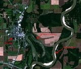
The River
Grayville had been at the northern end of a substantial 4-mile-long oxbowOxbow
An oxbow is a U-shaped wooden or metal frame that fits under and around the neck of an ox or bullock, with its upper ends passing through the bar of the yoke and held in place with a metal key, called a bow pin. The wood most often used is hardwood steamed into shape, like elm or hickory and...
bend of the main channel of the Wabash River
Wabash River
The Wabash River is a river in the Midwestern United States that flows southwest from northwest Ohio near Fort Recovery across northern Indiana to southern Illinois, where it forms the Illinois-Indiana border before draining into the Ohio River, of which it is the largest northern tributary...
. The river changed course after a flood in 1985, with the end result being that the town is now two miles from the river channel. Bonpas Creek
Bonpas Creek
Bonpas Creek is a tributary of the Wabash River in Illinois. It joins the Wabash near Grayville, Illinois. In the last of its watercourse, it occupies part of a former Wabash oxbow bend....
trickles through a portion of the former river channel, creating continued access to water for canoes, rafts, and extremely shallow-draft small boats.