
Grand Ronde Indian Reservation
Encyclopedia
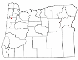
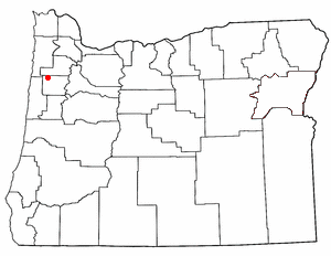
The Grand Ronde Community is an Indian reservation
located on several non-contiguous sections of land in southwestern Yamhill County
and northwestern Polk County
, Oregon
, United States
, about 18 miles (29 km) east of Lincoln City
, near the community of Grand Ronde
. Various tribes and bands from all parts of Western Oregon were removed from their homes in the mid-19th century and placed on this reservation. It is owned by the Confederated Tribes of the Grand Ronde Community of Oregon
. The reservation has a land area of 16.384 sq mi (42.434 km²) and a 2000 census
resident population of 55 persons.
 Grand Ronde Reservation is located near 45°3′42"N 123°36′56"W (45.061643, -123.615654).
Indian reservation
An American Indian reservation is an area of land managed by a Native American tribe under the United States Department of the Interior's Bureau of Indian Affairs...
located on several non-contiguous sections of land in southwestern Yamhill County
Yamhill County, Oregon
-National protected areas:*Siuslaw National Forest *Tualatin River National Wildlife Refuge -Demographics:As of the census of 2000, there were 84,992 people, 28,732 households, and 21,376 families residing in the county. The population density was 119 people per square mile . There were 30,270...
and northwestern Polk County
Polk County, Oregon
Polk County is a county located in the U.S. state of Oregon. The county is named for James Knox Polk, the 11th president of the United States. In 2010, its population was 75,403. The seat of the county is Dallas....
, Oregon
Oregon
Oregon is a state in the Pacific Northwest region of the United States. It is located on the Pacific coast, with Washington to the north, California to the south, Nevada on the southeast and Idaho to the east. The Columbia and Snake rivers delineate much of Oregon's northern and eastern...
, United States
United States
The United States of America is a federal constitutional republic comprising fifty states and a federal district...
, about 18 miles (29 km) east of Lincoln City
Lincoln City, Oregon
Lincoln City is a city in Lincoln County, Oregon, United States. It is named after the county. The population was 7,930 at the 2010 census.- History :...
, near the community of Grand Ronde
Grand Ronde, Oregon
Grand Ronde is a census-designated place and unincorporated community in Polk County, Oregon, United States. Originally named "Grand Ronde Agency", the name of this city is a variation of the French Grande Ronde or "fine large valley", a description given to the area by the employees of the...
. Various tribes and bands from all parts of Western Oregon were removed from their homes in the mid-19th century and placed on this reservation. It is owned by the Confederated Tribes of the Grand Ronde Community of Oregon
Confederated Tribes of the Grand Ronde Community of Oregon
The Confederated Tribes of the Grand Ronde Community of Oregon consists of twenty-seven Native American tribes with long historical ties to present-day Western Oregon between the western boundary of the Oregon Coast and the eastern boundary of the Cascade Range, and the northern boundary of...
. The reservation has a land area of 16.384 sq mi (42.434 km²) and a 2000 census
United States Census, 2000
The Twenty-second United States Census, known as Census 2000 and conducted by the Census Bureau, determined the resident population of the United States on April 1, 2000, to be 281,421,906, an increase of 13.2% over the 248,709,873 persons enumerated during the 1990 Census...
resident population of 55 persons.
Historical summary
- Since 6,000 B.C. or earlier, the Rogue River, UmpquaUmpqua (Native Americans)Umpqua refers to any of several distinct groups of Native Americans that live in present-day south central Oregon in the United States.The Upper Umpqua tribe is represented as the Cow Creek Band of Umpqua Tribe of Indians. The tribe signed a treaty with the U.S. federal government on September 19,...
, Chasta, Kalapuya, MolallaMolalaThe Molala were a people of the Plateau culture area in central Oregon, United States. Some consider them extinct, though they are one of the Confederated Tribes of the Grand Ronde Community of Oregon, with 141 of the 882 members in the 1950s claiming Molala descent.-Language:The Molalla language...
, Salmon River, TillamookTillamook (tribe)The Nehalem or Tillamook are a Native American tribe from Oregon of the Salish linguistic group. The name "Tillamook" is a Chinook term meaning "people of Nekelim " and is also spelled Calamox, Gillamooks and Killamook....
, and Nestucca Indians lived in their traditional homelands - 1854-1857: In the wake of the Rogue River WarsRogue River WarsThe Rogue River Wars was an armed conflict between the US Army, local militias and volunteers, and the Native American tribes commonly grouped under the designation of Rogue River Indians, in the Rogue River Valley area of what today is southern Oregon in 1855–56...
, the Grand Ronde reservation established by treaty arrangements in 1854 and 1855 and an Executive Order of June 30, 1857 - 1856: Fort YamhillFort YamhillFort Yamhill was an American military fortification in what became the state of Oregon. Built in 1856 in the Oregon Territory, it remained an active post until 1866. The Army outpost was used to provide a presence next to the Grand Ronde Agency Coastal Reservation...
built next to reservation - 1860's: Arrival of the Belgian Catholic missionary Father Adrien Croquet (renamed Crockett), uncle of the famous Cardinal Mercier - later followed by his nephew Joseph Mercier. The non-ordained Joseph married into a local tribe, and many present-day tribespeople are among his descendants.
- 1887: the General Allotment Act makes allotments to individuals totaling slightly over 33,000 acres (130 km²) of Reservation land. Most of this ends up in the hands of non-Indians.
- 1901: U.S. Inspector James McLaughlin declared a 25,791 acre (104.4 km²) tract of the reservation "surplus" and the U.S. sold it for $1.16 per acre ($287/km²).
- 1936: Indian Reorganization ActIndian Reorganization ActThe Indian Reorganization Act of June 18, 1934 the Indian New Deal, was U.S. federal legislation that secured certain rights to Native Americans, including Alaska Natives...
enables the Tribe to re-purchase some land for homes - 1954: Termination Act
- 1983: Grand Ronde Restoration Act: On November 22, 1983, President Ronald Reagan signed the Grand Ronde Restoration Act.
- 1988: Tribe regains 9,811 acres (39.7 km²). This is now about 10,052 acres (45 km²).
Geography