
Gove Peninsula
Encyclopedia
The Gove Peninsula is at the northeastern corner of Arnhem Land
in the Northern Territory
of Australia
. The peninsula became strategically important during World War II
when an airforce
base was constructed at what is now Gove Airport
. The peninsula was named after Pilot Officer William Gove, who was killed in action in 1943.
 The Gove Peninsula is located on the east coast of the Gulf of Carpentaria
within Arnhem Land
, a vast tract of Aboriginal
owned land on the Northern Territory
coastline. The township of Nhulunbuy is the main commercial and service centre of the Peninsula and is 600 kilometres east of Darwin
.
. Their stories tell of creation ancestors who had adventures across the country forming the land formations, plants, rocks, oceans, animals, people and law. The law determines every aspect of life, from social obligations and religion to land ownership and responsibility. The earliest record of contact with outsiders was with the Macassan traders from the 16th century on. They were from Eastern Indonesia
and visited Arnhem Land
every wet season
. For over three hundred years they collected and processed sea slugs for trade with China
. They traded objects such as metal knives, tobacco and cloth with Yolngu any many Yolngu words, songs and dances encompass influence from these Macassan traders.
The first recorded contact with Europeans was in 1623 when William van Colster led an exploratory voyage for the Dutch. He named Cape Arnhem after his ship, which was named Arnhem. Several other explorations took European visitors fleetingly to this region, but it wasn’t until Matthew Flinders
circumnavigated Australia
, that the coast of Arnhem Land
was detailed on a chart. Flinders recorded coming across a Macassan Fishing Fleet just north-west of the Gove Peninsula on the English Company’s Islands. The start of the 20th Century saw the end to Macassan trade when the South Australian Government refused to allow the trade with the introduction of legislation to protect Australia's "territorial integrity".
Aboriginal Reserve. Today the Land Trust holds about 1000,000 km2 as Aboriginal freehold land (with the exception of mining leases).
The Gove Peninsula was heavily involved in the defence of Australia during World War II
. There were three operational air squadrons based here as well as an airfield on the site on the present Gove airport and a flying boat base at Drimmie Head. The Peninsula derived its name from a RAAF navigator who died in a mid air collision in the vicinity. There are reminders of this time found throughout the Peninsula and a war memorial in Yirkalla dedicated to the efforts of Yolngu trained to defend against the Japanese.
and increased in the non-urban areas.
maintaining strong ties with their land, religion and traditions.
Rather than the name of a clan or family group, Yolngu is the word that Aboriginal people from East Arnhem Land, including the Gove Peninsula, use to refer to themselves. The main five clan groups of the region are Gumatj, Rirratjingu, Djapu, Madarrpa and Dhalwangu.
Any non-Yolngu person is called a Balanda (thought to originate from the word 'Hollander' for a white or Dutch person). Aboriginal owned land is private land and holds many sites that are sacred and special to its owners. Therefore visitors need to obtain a permit when going onto Aboriginal owned land. This helps the owners of the land give access to visitors whilst still retaining their privacy and ensuring that their sacred and special sites are not disrupted.
Yolngu enjoy a settled and relatively dense population and Yirrkala is the largest Yolngu community in North-east Arnhem Land with a population of around 800 people. Many other Yolngu live in small family groups on their traditional lands throughout the region. Their culture is strong and most people live a mix between a traditional and modern life. The land is abundant with flora
and fauna
that is still part of hunting and gathering today.
 Situated just 12 degrees south
of the Equator
, the Gove Peninsula has a monsoon climate. The non-Aboriginal people of the Northern Territory
tropics recognise two distinct seasons, the dry season
from May to October, and the wet from November to April. During the dry, temperatures range from 15 to 18 degrees Celsius at night to 28 to 30 degrees Celsius during the day. There is virtually no rainfall, clear blue skies and cool ocean breezes. The wet season brings the monsoon weather with hot and humid days ranging from 31 to 35 degrees Celsius and warm nights. Electrical storms are spectacular and there can be cyclonic activity. Humidity
is high and rainfall averages between 100 to 300 milli-metres per month with an annual rainfall around 1100 milli-metres.
Yolngu however recognise eight seasons derived from changing behaviours and patterns apparent in the land, flora and fauna. Yolngu seasons calendar Dhuludur’ (‘the Pre-wet season’, October–November) when the weather is erratic, ‘female’ thunder and lightning storms are frequent, turtles and Threadfin Salmon are hunted, and the ‘male’ thunder shrinks the waterholes. Bärra’mirri (‘the season of Heavy Rain and Growth’, December–January) when there is heavy rains and prolific plant growth, the Magpie Geese arrive and shellfish
are harvested. Mayaltha (‘the Flowering season’, February–March) when there are bright sunny days but little bush tucker, flies arrive and mosquito
larvae are abundant in the pools. Midawarr (‘the Fruiting season’, March–April) when the east wind signals a time of abundant bush foods, including fruits, nuts and barramundi. Ngathangamakulingamirri (‘a two week Harvest season’, April) Dharratharramirri (‘the Early Dry season’, May–July) when the trade winds (south-southeast) arrive, the bush is fired, Magpie Lark flocks arrive and sharks and stingrays give birth. Burrugumirri (‘the time of the Birthing of Sharks and Stingrays’, three weeks in July to August) Rarrandharr (‘the Main Dry season’, August–October) when warm southeast winds blow, the soil is hot, young sharks and stingrays are hunted, and the stringybark flowers. National Oceans Office, 2003, Snapshot of the Northern Planning Area, Hobart.
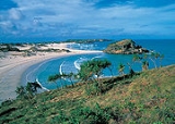
The Gove Peninsula is barely touched by western development, with the exceptions of Nhulunbuy and the bauxite
mine and alumina refinery. There are vast tracts of unspoilt land, beaches and ocean. The land is characterised by a mixture of savannah woodland, wetlands and patches of monsoon
forest and rocky escarpment. The beaches, bays and islands are idyllic with stretches of beautiful white sand and clear blue ocean waters. Some favourite destinations of locals and visitors alike are Nanydjaka (Cape Arnhem), Lurrupukurru (Oyster Beach), Rangura (Caves Beach), Baringura (Little Bondi), Ngumuy (Turtle Beach), Garanhan (Macassan Beach), and Daliwuy (Daliwoi Bay).
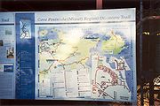
There are three marked coastal walking trails, providing relatively short and pleasant walks. These are Daliwuy to Garanhan (3 km, red trail marker), Garanhan to Ngumuy (2.5 km, yellow trail marker) and Ngumuy to Baringura (1.5 km, black trail marker). Yolngu elders have provided interpretive material along the way so visitors can enjoy and appreciate their rich culture and beliefs.
mine and alumina refinery 15 kilometres away. The town is built on a Special Purpose Lease on Aboriginal land and is now the largest town is East Arnhem Land, the fourth largest town in the Northern Territory
and the administrative centre for the region.
The economy of the Gove Peninsula is centred on the Alcan Gove Mine and Refinery which is located of leasehold land within the boundaries of Aboriginal freehold land.
 The Commonwealth Government carried out mineral explorations in the 1950s and was successful in discovering a bauxite deposit that covered 65 km2 and contained an estimated 250 million tonnes. After initial resistance by the government to mine, in 1964 Nabalco, the former owner of the mine and refinery, was set up and granted a lease with a commitment build a township, port facility and mine. In 1968 The Gove Agreement was negotiated between Nabalco and the Commonwealth Government. This agreement sets out the terms and conditions under which the mine and refinery still operate today and includes the granting of a series of leases to Nabalco and set out obligations and responsibilities, including relations with the local Aboriginal people. Today this agreement stands between Alcan Gove and Commonwealth Government. Royalties are paid on the bauxite exported and refined, with the level of royalties reviewed every seven years. These royalties are paid directly to the Northern Territory Government and an equivalent amount is paid by the Commonwealth Government to the Aboriginal Benefit Trust Account and distributed according to a formula set out in the Commonwealth Land Rights Act.
On the night of the 2001 there were 3,766 people living in the ‘Urban Centre’ of Nhulunbuy. Of these 7.3% were Aboriginal people.
 It is possible to hire four wheel drives, conventional vehicles or bicycles in Nhulunbuy and an airport bus and taxi company service the town.
 The Gove Airport
is located 13 km from the town centre of Nhulunbuy. Qantas and AirNorth have a daily flight to Gove from Cairns and Darwin which then connect to cities around the world. The Cairns – Gove flight is 1 hour and 40 minutes duration and Darwin – Gove is 1 hour and 10 minutes.
and non-Indigenous people travel from around Australia and the world to attend the festival to learn and contribute. Garma is a Yolngu word for ‘two-way learning process’. There is traditional and contemporary music
and dance, art and craft, education, performances and sport. Art and craft is gaining worldwide recognition and is an opportunity for Yolngu to gain economic independence. The Gove Peninsula has three outstanding art centres, Nambara Arts and Crafts near Nhulunbuy, Buku Larrngay Mulka in Yirrkala and Elcho Island Art and Craft. The artists of North East Arnhem continue to paint their sacred designs using ochre
s on bark. This not only reflects the sanctity of their connection with the land they paint but an artistic discipline that is recognised internationally.
, including the Gove Peninsula, is home to what is commonly referred to as the didgeridoo
and Yolngu are master players and craftsmen of the instrument. In this region, therhythms, techniques and compositions endemic to the people are of outstanding musical interest. Characteristic features in the playing styles of north-east Arnhem Land include sharp tongued accents, syncopated overtone rhythms, and variable time metering.
Didgeridoos from north-east Arnhem Land are instruments of the highest cultural integrity. The use of the didgeridoo in this part of Australia continues as an unbroken tradition since time immemorial. In recent times, the Yothu Yindi band and Djalu Gurruwiwi - Mr Didgeridoo himself - has done much to popularise the yidaki around the world. Yidaki are commonly made in north-east Arnhem Land from gadayka - Eucalyptus tetradonta or Stringybark, gungurru - Eucalyptus miniata
or Woolybutt, and badawili - Eucalyptus ferruginea or Rusty Bloodwood.
Sailing
Gove Harbour is a popular stop off point for yachts sailing the northern coast of Australia or heading to the countries to the north of Australia and beyond. Apart from the months of December to April when cyclones can affect the coast line, the waters surrounding the Gove Peninsula provide excellent sailing conditions. The Gove Boat Club is often packed full of visiting yachties from all over the world and the club often holds regattas and other annual events.
Fishing
There are numerous well established fishing tour operators than run full day and extended tours from both Nhulunbuy as well as a number of fishing clubs in the region that organise renowned fishing competitions throughout the year. Anglers have the chance of hooking up one of more than 30 fish species, including red emperor, coral trout and golden snapper, Spanish mackerel, giant trevally and, in the billabongs, the prized barramundi
.
Diving
Diving the colourful and rich coral reefs in the clear waters offshore from Gove is becoming more and more popular. There is drift, deep and multi-level diving available and many reefs and offshore islands to explore. It is recommended to dive in company of an experienced dive charter operator to ensure safety in these remote tropical waters, as saltwater crocodiles are extremely common in this region. There are two reputable dive companies in Nhulunbuy who offer dive tours and short courses.
Arnhem Land
The Arnhem Land Region is one of the five regions of the Northern Territory of Australia. It is located in the north-eastern corner of the territory and is around 500 km from the territory capital Darwin. The region has an area of 97,000 km² which also covers the area of Kakadu National...
in the Northern Territory
Northern Territory
The Northern Territory is a federal territory of Australia, occupying much of the centre of the mainland continent, as well as the central northern regions...
of Australia
Australia
Australia , officially the Commonwealth of Australia, is a country in the Southern Hemisphere comprising the mainland of the Australian continent, the island of Tasmania, and numerous smaller islands in the Indian and Pacific Oceans. It is the world's sixth-largest country by total area...
. The peninsula became strategically important during World War II
World War II
World War II, or the Second World War , was a global conflict lasting from 1939 to 1945, involving most of the world's nations—including all of the great powers—eventually forming two opposing military alliances: the Allies and the Axis...
when an airforce
Royal Australian Air Force
The Royal Australian Air Force is the air force branch of the Australian Defence Force. The RAAF was formed in March 1921. It continues the traditions of the Australian Flying Corps , which was formed on 22 October 1912. The RAAF has taken part in many of the 20th century's major conflicts...
base was constructed at what is now Gove Airport
Gove Airport
All flights are met by a shuttle bus connecting to Nhulunbuy.- Statistics :Gove Airport was ranked 42nd in Australia for the number of revenue passengers served in financial year 2009-2010....
. The peninsula was named after Pilot Officer William Gove, who was killed in action in 1943.
Location
Gulf of Carpentaria
The Gulf of Carpentaria is a large, shallow sea enclosed on three sides by northern Australia and bounded on the north by the Arafura Sea...
within Arnhem Land
Arnhem Land
The Arnhem Land Region is one of the five regions of the Northern Territory of Australia. It is located in the north-eastern corner of the territory and is around 500 km from the territory capital Darwin. The region has an area of 97,000 km² which also covers the area of Kakadu National...
, a vast tract of Aboriginal
Australian Aborigines
Australian Aborigines , also called Aboriginal Australians, from the latin ab originem , are people who are indigenous to most of the Australian continentthat is, to mainland Australia and the island of Tasmania...
owned land on the Northern Territory
Northern Territory
The Northern Territory is a federal territory of Australia, occupying much of the centre of the mainland continent, as well as the central northern regions...
coastline. The township of Nhulunbuy is the main commercial and service centre of the Peninsula and is 600 kilometres east of Darwin
Darwin, Northern Territory
Darwin is the capital city of the Northern Territory, Australia. Situated on the Timor Sea, Darwin has a population of 127,500, making it by far the largest and most populated city in the sparsely populated Northern Territory, but the least populous of all Australia's capital cities...
.
Early
Yolngu have made this country home for at least 50,000 years. Their history is told in their dances, songs, stories and rock artRock art
Rock art is a term used in archaeology for any human-made markings made on natural stone. They can be divided into:*Petroglyphs - carvings into stone surfaces*Pictographs - rock and cave paintings...
. Their stories tell of creation ancestors who had adventures across the country forming the land formations, plants, rocks, oceans, animals, people and law. The law determines every aspect of life, from social obligations and religion to land ownership and responsibility. The earliest record of contact with outsiders was with the Macassan traders from the 16th century on. They were from Eastern Indonesia
Indonesia
Indonesia , officially the Republic of Indonesia , is a country in Southeast Asia and Oceania. Indonesia is an archipelago comprising approximately 13,000 islands. It has 33 provinces with over 238 million people, and is the world's fourth most populous country. Indonesia is a republic, with an...
and visited Arnhem Land
Arnhem Land
The Arnhem Land Region is one of the five regions of the Northern Territory of Australia. It is located in the north-eastern corner of the territory and is around 500 km from the territory capital Darwin. The region has an area of 97,000 km² which also covers the area of Kakadu National...
every wet season
Wet season
The the wet season, or rainy season, is the time of year, covering one or more months, when most of the average annual rainfall in a region occurs. The term green season is also sometimes used as a euphemism by tourist authorities. Areas with wet seasons are dispersed across portions of the...
. For over three hundred years they collected and processed sea slugs for trade with China
China
Chinese civilization may refer to:* China for more general discussion of the country.* Chinese culture* Greater China, the transnational community of ethnic Chinese.* History of China* Sinosphere, the area historically affected by Chinese culture...
. They traded objects such as metal knives, tobacco and cloth with Yolngu any many Yolngu words, songs and dances encompass influence from these Macassan traders.
The first recorded contact with Europeans was in 1623 when William van Colster led an exploratory voyage for the Dutch. He named Cape Arnhem after his ship, which was named Arnhem. Several other explorations took European visitors fleetingly to this region, but it wasn’t until Matthew Flinders
Matthew Flinders
Captain Matthew Flinders RN was one of the most successful navigators and cartographers of his age. In a career that spanned just over twenty years, he sailed with Captain William Bligh, circumnavigated Australia and encouraged the use of that name for the continent, which had previously been...
circumnavigated Australia
Australia
Australia , officially the Commonwealth of Australia, is a country in the Southern Hemisphere comprising the mainland of the Australian continent, the island of Tasmania, and numerous smaller islands in the Indian and Pacific Oceans. It is the world's sixth-largest country by total area...
, that the coast of Arnhem Land
Arnhem Land
The Arnhem Land Region is one of the five regions of the Northern Territory of Australia. It is located in the north-eastern corner of the territory and is around 500 km from the territory capital Darwin. The region has an area of 97,000 km² which also covers the area of Kakadu National...
was detailed on a chart. Flinders recorded coming across a Macassan Fishing Fleet just north-west of the Gove Peninsula on the English Company’s Islands. The start of the 20th Century saw the end to Macassan trade when the South Australian Government refused to allow the trade with the introduction of legislation to protect Australia's "territorial integrity".
Modern
As Europeans started land exploration throughout Australia and subsequently started to settle closer and closer to Yolngu homelands, conflict between Europeans and Yolngu became more frequent. In 1931 ,an area of 96,000 km2 was proclaimed Arnhem LandArnhem Land
The Arnhem Land Region is one of the five regions of the Northern Territory of Australia. It is located in the north-eastern corner of the territory and is around 500 km from the territory capital Darwin. The region has an area of 97,000 km² which also covers the area of Kakadu National...
Aboriginal Reserve. Today the Land Trust holds about 1000,000 km2 as Aboriginal freehold land (with the exception of mining leases).
The Gove Peninsula was heavily involved in the defence of Australia during World War II
World War II
World War II, or the Second World War , was a global conflict lasting from 1939 to 1945, involving most of the world's nations—including all of the great powers—eventually forming two opposing military alliances: the Allies and the Axis...
. There were three operational air squadrons based here as well as an airfield on the site on the present Gove airport and a flying boat base at Drimmie Head. The Peninsula derived its name from a RAAF navigator who died in a mid air collision in the vicinity. There are reminders of this time found throughout the Peninsula and a war memorial in Yirkalla dedicated to the efforts of Yolngu trained to defend against the Japanese.
Demographics
Based on a 2004 NT Government Socio-Economic Snapshot, there is a population of 14,115 within the Gove Peninsula (East Arnhem Region), of which almost 64% are Indigenous people and a population of nearly 4,000 in Nhulunbuy, the majority being non-Indigenous people. Those people not living in Nhulunbuy live in surrounding communities and traditional homelands. It is interesting to note that in the five years to 2004, the population declined in Nhulunbuy and Groote EylandtGroote Eylandt
Groote Eylandt is the largest island in the Gulf of Carpentaria in northeastern Australia. It is the homeland of, and is owned by, the Anindilyakwa people who speak the isolated Anindilyakwa language)....
and increased in the non-urban areas.
Indigenous community
Owned by the traditional Aboriginal owners, the Yolngu people, it is a place rich in culture with YolnguYolngu
The Yolngu or Yolŋu are an Indigenous Australian people inhabiting north-eastern Arnhem Land in the Northern Territory of Australia. Yolngu means “person” in the Yolŋu languages.-Yolŋu law:...
maintaining strong ties with their land, religion and traditions.
Rather than the name of a clan or family group, Yolngu is the word that Aboriginal people from East Arnhem Land, including the Gove Peninsula, use to refer to themselves. The main five clan groups of the region are Gumatj, Rirratjingu, Djapu, Madarrpa and Dhalwangu.
Any non-Yolngu person is called a Balanda (thought to originate from the word 'Hollander' for a white or Dutch person). Aboriginal owned land is private land and holds many sites that are sacred and special to its owners. Therefore visitors need to obtain a permit when going onto Aboriginal owned land. This helps the owners of the land give access to visitors whilst still retaining their privacy and ensuring that their sacred and special sites are not disrupted.
Yolngu enjoy a settled and relatively dense population and Yirrkala is the largest Yolngu community in North-east Arnhem Land with a population of around 800 people. Many other Yolngu live in small family groups on their traditional lands throughout the region. Their culture is strong and most people live a mix between a traditional and modern life. The land is abundant with flora
Flora
Flora is the plant life occurring in a particular region or time, generally the naturally occurring or indigenous—native plant life. The corresponding term for animals is fauna.-Etymology:...
and fauna
Fauna
Fauna or faunæ is all of the animal life of any particular region or time. The corresponding term for plants is flora.Zoologists and paleontologists use fauna to refer to a typical collection of animals found in a specific time or place, e.g. the "Sonoran Desert fauna" or the "Burgess shale fauna"...
that is still part of hunting and gathering today.
Topography and climate
12th parallel south
The 12th parallel south is a circle of latitude that is 12 degrees south of the Earth's equatorial plane. It crosses the Atlantic Ocean, Africa, the Indian Ocean, Australasia, the Pacific Ocean and South America....
of the Equator
Equator
An equator is the intersection of a sphere's surface with the plane perpendicular to the sphere's axis of rotation and containing the sphere's center of mass....
, the Gove Peninsula has a monsoon climate. The non-Aboriginal people of the Northern Territory
Northern Territory
The Northern Territory is a federal territory of Australia, occupying much of the centre of the mainland continent, as well as the central northern regions...
tropics recognise two distinct seasons, the dry season
Dry season
The dry season is a term commonly used when describing the weather in the tropics. The weather in the tropics is dominated by the tropical rain belt, which oscillates from the northern to the southern tropics over the course of the year...
from May to October, and the wet from November to April. During the dry, temperatures range from 15 to 18 degrees Celsius at night to 28 to 30 degrees Celsius during the day. There is virtually no rainfall, clear blue skies and cool ocean breezes. The wet season brings the monsoon weather with hot and humid days ranging from 31 to 35 degrees Celsius and warm nights. Electrical storms are spectacular and there can be cyclonic activity. Humidity
Humidity
Humidity is a term for the amount of water vapor in the air, and can refer to any one of several measurements of humidity. Formally, humid air is not "moist air" but a mixture of water vapor and other constituents of air, and humidity is defined in terms of the water content of this mixture,...
is high and rainfall averages between 100 to 300 milli-metres per month with an annual rainfall around 1100 milli-metres.
Yolngu however recognise eight seasons derived from changing behaviours and patterns apparent in the land, flora and fauna. Yolngu seasons calendar Dhuludur’ (‘the Pre-wet season’, October–November) when the weather is erratic, ‘female’ thunder and lightning storms are frequent, turtles and Threadfin Salmon are hunted, and the ‘male’ thunder shrinks the waterholes. Bärra’mirri (‘the season of Heavy Rain and Growth’, December–January) when there is heavy rains and prolific plant growth, the Magpie Geese arrive and shellfish
Shellfish
Shellfish is a culinary and fisheries term for exoskeleton-bearing aquatic invertebrates used as food, including various species of molluscs, crustaceans, and echinoderms. Although most kinds of shellfish are harvested from saltwater environments, some kinds are found only in freshwater...
are harvested. Mayaltha (‘the Flowering season’, February–March) when there are bright sunny days but little bush tucker, flies arrive and mosquito
Mosquito
Mosquitoes are members of a family of nematocerid flies: the Culicidae . The word Mosquito is from the Spanish and Portuguese for little fly...
larvae are abundant in the pools. Midawarr (‘the Fruiting season’, March–April) when the east wind signals a time of abundant bush foods, including fruits, nuts and barramundi. Ngathangamakulingamirri (‘a two week Harvest season’, April) Dharratharramirri (‘the Early Dry season’, May–July) when the trade winds (south-southeast) arrive, the bush is fired, Magpie Lark flocks arrive and sharks and stingrays give birth. Burrugumirri (‘the time of the Birthing of Sharks and Stingrays’, three weeks in July to August) Rarrandharr (‘the Main Dry season’, August–October) when warm southeast winds blow, the soil is hot, young sharks and stingrays are hunted, and the stringybark flowers. National Oceans Office, 2003, Snapshot of the Northern Planning Area, Hobart.
The Gove Peninsula is barely touched by western development, with the exceptions of Nhulunbuy and the bauxite
Bauxite
Bauxite is an aluminium ore and is the main source of aluminium. This form of rock consists mostly of the minerals gibbsite Al3, boehmite γ-AlO, and diaspore α-AlO, in a mixture with the two iron oxides goethite and hematite, the clay mineral kaolinite, and small amounts of anatase TiO2...
mine and alumina refinery. There are vast tracts of unspoilt land, beaches and ocean. The land is characterised by a mixture of savannah woodland, wetlands and patches of monsoon
Monsoon
Monsoon is traditionally defined as a seasonal reversing wind accompanied by corresponding changes in precipitation, but is now used to describe seasonal changes in atmospheric circulation and precipitation associated with the asymmetric heating of land and sea...
forest and rocky escarpment. The beaches, bays and islands are idyllic with stretches of beautiful white sand and clear blue ocean waters. Some favourite destinations of locals and visitors alike are Nanydjaka (Cape Arnhem), Lurrupukurru (Oyster Beach), Rangura (Caves Beach), Baringura (Little Bondi), Ngumuy (Turtle Beach), Garanhan (Macassan Beach), and Daliwuy (Daliwoi Bay).
There are three marked coastal walking trails, providing relatively short and pleasant walks. These are Daliwuy to Garanhan (3 km, red trail marker), Garanhan to Ngumuy (2.5 km, yellow trail marker) and Ngumuy to Baringura (1.5 km, black trail marker). Yolngu elders have provided interpretive material along the way so visitors can enjoy and appreciate their rich culture and beliefs.
Government
There are 10 local councils in the region which administer the townships of Nhulunbuy and Angurugu and a number of local communities that primarily service Indigenous people. .Economy
Nhulunbuy is a purpose built town developed by the former owner of Alcan Gove, a huge bauxiteBauxite
Bauxite is an aluminium ore and is the main source of aluminium. This form of rock consists mostly of the minerals gibbsite Al3, boehmite γ-AlO, and diaspore α-AlO, in a mixture with the two iron oxides goethite and hematite, the clay mineral kaolinite, and small amounts of anatase TiO2...
mine and alumina refinery 15 kilometres away. The town is built on a Special Purpose Lease on Aboriginal land and is now the largest town is East Arnhem Land, the fourth largest town in the Northern Territory
Northern Territory
The Northern Territory is a federal territory of Australia, occupying much of the centre of the mainland continent, as well as the central northern regions...
and the administrative centre for the region.
The economy of the Gove Peninsula is centred on the Alcan Gove Mine and Refinery which is located of leasehold land within the boundaries of Aboriginal freehold land.
Demographics
On the night of the 2001 Census there were 13,080 people living in the ‘Indigenous region’ of Nhulunbuy, which covers most of the Gove Peninsula. Of these 60.7% were Aboriginal people.| Population | Percentage | |
|---|---|---|
| Total Persons | 13,080 | - |
| Total Indigenous persons | 7,940 | 60.7% |
| Males | 3,905 | 49.2% |
| Females | 4,035 | 50.8% |
On the night of the 2001 there were 3,766 people living in the ‘Urban Centre’ of Nhulunbuy. Of these 7.3% were Aboriginal people.
| Population | Percentage | |
|---|---|---|
| Total Persons | 3,766 | - |
| Total Indigenous persons | 275 | 7.3% |
| Males | 2,135 | 56.7% |
| Females | 1,631 | 43.3% |
Transport
Air
Gove Airport
All flights are met by a shuttle bus connecting to Nhulunbuy.- Statistics :Gove Airport was ranked 42nd in Australia for the number of revenue passengers served in financial year 2009-2010....
is located 13 km from the town centre of Nhulunbuy. Qantas and AirNorth have a daily flight to Gove from Cairns and Darwin which then connect to cities around the world. The Cairns – Gove flight is 1 hour and 40 minutes duration and Darwin – Gove is 1 hour and 10 minutes.
Road
The most direct route to Nhulunbuy from a major Highway is via the Central Arnhem Road which leaves the Stuart Highway 52 km south of Katherine. The first 30 kilometres are sealed and then the rest is a gravel road. A four-wheel-drive vehicle is recommended, particularly for the two major river crossings, the Wilton River near Bulman Aboriginals Community and the Goyder River, about 300 kilometres from Nhulunbuy. Fuel needs to be carried as travellers may not be able to purchase fuel along the way. The Central Arnhem Road is 682 kilometres long, plus the 52 kilometres from Katherine to the turnoff makes a long drive, approximately 8 or 9 hours drive with good conditions. Travellers require a permit as the road runs across many Yolngu Clan lands.Education
Nhulunbuy has one public primary school, which incorporates pre-school, and one public secondary school which provides education to a Year 12 level. There is also a private school, Nhulunbuy Christian School, which provides education from Transition to Year 9. Yirrkala has a school which supports further a field community schools.Society and culture
Yolngu culture and ties to the land are still very strong and sacred. Many people still live mainly a traditional life. Each August, Gulkula near Nhulunbuy, holds the Garma festival. This is a celebration of Yolngu culture is considered one of the most important indigenous festivals in Australia. Around 2,000 IndigenousIndigenous Australians
Indigenous Australians are the original inhabitants of the Australian continent and nearby islands. The Aboriginal Indigenous Australians migrated from the Indian continent around 75,000 to 100,000 years ago....
and non-Indigenous people travel from around Australia and the world to attend the festival to learn and contribute. Garma is a Yolngu word for ‘two-way learning process’. There is traditional and contemporary music
Music
Music is an art form whose medium is sound and silence. Its common elements are pitch , rhythm , dynamics, and the sonic qualities of timbre and texture...
and dance, art and craft, education, performances and sport. Art and craft is gaining worldwide recognition and is an opportunity for Yolngu to gain economic independence. The Gove Peninsula has three outstanding art centres, Nambara Arts and Crafts near Nhulunbuy, Buku Larrngay Mulka in Yirrkala and Elcho Island Art and Craft. The artists of North East Arnhem continue to paint their sacred designs using ochre
Ochre
Ochre is the term for both a golden-yellow or light yellow brown color and for a form of earth pigment which produces the color. The pigment can also be used to create a reddish tint known as "red ochre". The more rarely used terms "purple ochre" and "brown ochre" also exist for variant hues...
s on bark. This not only reflects the sanctity of their connection with the land they paint but an artistic discipline that is recognised internationally.
Music
Arnhem LandArnhem Land
The Arnhem Land Region is one of the five regions of the Northern Territory of Australia. It is located in the north-eastern corner of the territory and is around 500 km from the territory capital Darwin. The region has an area of 97,000 km² which also covers the area of Kakadu National...
, including the Gove Peninsula, is home to what is commonly referred to as the didgeridoo
Didgeridoo
The didgeridoo is a wind instrument developed by Indigenous Australians of northern Australia around 1,500 years ago and still in widespread usage today both in Australia and around the world. It is sometimes described as a natural wooden trumpet or "drone pipe"...
and Yolngu are master players and craftsmen of the instrument. In this region, therhythms, techniques and compositions endemic to the people are of outstanding musical interest. Characteristic features in the playing styles of north-east Arnhem Land include sharp tongued accents, syncopated overtone rhythms, and variable time metering.
Didgeridoos from north-east Arnhem Land are instruments of the highest cultural integrity. The use of the didgeridoo in this part of Australia continues as an unbroken tradition since time immemorial. In recent times, the Yothu Yindi band and Djalu Gurruwiwi - Mr Didgeridoo himself - has done much to popularise the yidaki around the world. Yidaki are commonly made in north-east Arnhem Land from gadayka - Eucalyptus tetradonta or Stringybark, gungurru - Eucalyptus miniata
Eucalyptus miniata
The Darwin woollybutt is a eucalypt which is native to Australia's Top End, found from Cape York in north Queensland across through to the Northern Territory into the Kimberley Region of northern Western Australia. It is a medium-sized tree which can reach 15–25 m in height. The bark is soft and...
or Woolybutt, and badawili - Eucalyptus ferruginea or Rusty Bloodwood.
Sport and recreation
Sport is a big part of the lives of people in Nhulunbuy and there are facilities including a sports ground, golf course, yacht club, swimming pool, fishing club, surf-lifesaving club, speedway and skate park. Along with this many take part in four-wheel driving, fishing, diving, camping and boating.Sailing
Gove Harbour is a popular stop off point for yachts sailing the northern coast of Australia or heading to the countries to the north of Australia and beyond. Apart from the months of December to April when cyclones can affect the coast line, the waters surrounding the Gove Peninsula provide excellent sailing conditions. The Gove Boat Club is often packed full of visiting yachties from all over the world and the club often holds regattas and other annual events.
Fishing
There are numerous well established fishing tour operators than run full day and extended tours from both Nhulunbuy as well as a number of fishing clubs in the region that organise renowned fishing competitions throughout the year. Anglers have the chance of hooking up one of more than 30 fish species, including red emperor, coral trout and golden snapper, Spanish mackerel, giant trevally and, in the billabongs, the prized barramundi
Barramundi
The Barramundi , also known as Asian Seabass, is a species of catadromous fish in family Latidae of order Perciformes. The native species is widely distributed in the Indo-West Pacific region from the Persian Gulf, through Southeast Asia to Papua New Guinea and Northern Australia. Known in Thai...
.
Diving
Diving the colourful and rich coral reefs in the clear waters offshore from Gove is becoming more and more popular. There is drift, deep and multi-level diving available and many reefs and offshore islands to explore. It is recommended to dive in company of an experienced dive charter operator to ensure safety in these remote tropical waters, as saltwater crocodiles are extremely common in this region. There are two reputable dive companies in Nhulunbuy who offer dive tours and short courses.