
Glen Lui
Encyclopedia
Glen Lui from Gleann Laoigh – calves' glen – Gordon (1925) is one of the major glen
s on the Mar Lodge Estate
, in Aberdeenshire
, Scotland.
Its main watercourse
is the Lui Water a tributary
of the River Dee
, which it joins about a half-mile downstream from the Linn of Dee.
created in the 1980s.
Before the Plantation was created the wartime occupation was evident on the ground with concrete blocks on the surface, partially rotted logs 'nailed' together with ½" spikes. In some of the standing Scots Pine
s were mounted insulators for carrying wire – presumably for their telephone system.
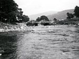
 Near the small beach on the south side of the Canadian Campsite a log-bridge crossed the River Dee and there are still spiked-logs on the north bank and spikes in the rock on the south-bank to show its exact position. The bridge survived into the 1960s – Wyness (1968) shows a photograph of the bridge adding in his notes:
Until the Plantation was created the Canadian Campsite was used as a campsite by campers and caravaners. Hillwalkers camped overnight before heading into the Cairngorms
or continuing their journey to Braemar
. Some of the caravan owners left their caravans at the Canadian Campsite on a semi-permanent basis with 'regulars' maintaining a weekend and holiday community. Mar Lodge Estate more than tolerated the use of this area as a campsite – they managed the 'rubbish problem' on the campsite by maintaining a rubbish pit – covering it over when full, and digging another nearby.
Also on the Canadian Campsite there was a 'big ditch' apparently man-made, that appeared to have been open to the Lui Water. At its deepest and widest point the ditch was over 10 feet deep, and 20 feet wide. There were many 'spiked' logs at regular intervals along the ditch and perpendicular to its axis.
About a hundred and fifty yards from its confluence with the River Dee, the Lui Water is bridged by a public road at the Linn of Lui. This public road leads (roughly E) towards Mar Lodge
and Allanaquoich
, and (roughly W) towards Linn of Dee.
. This route can be followed up Glen Lui following the course of the Lui Water from either the wooden gate at the public road or from the Linn of Dee car park by follow the signposted track through the plantation
. Either way – heading (roughly N) the landrover road leads to the Black Bridge.
In the Lui Water slightly upriver from the bridge are the remains of 'sluices and concrete banks' created by the Canadians in their occupation of the area – Watson (1975).
This part of Glen Lui is a broad glaciated valley dotted with moraines – the remains of the ancient glacial past. Other remains – seen as grassy, roughly rectangular outlines – are those of the townships and farms.
In Gordon (1925) the author laments:
Fortunately for us – in Gordon (1925) and Gordon (1948) the author has done much to record local place-names, and knowledge of the Cairngorms, that would otherwise be lost.
For example – in Gordon (1925) the author gives name to the two moraines of Glen Lui just upriver from Black Bridge – Da Shithean – Two Fairy Mounds.
1:25 000 maps – a footpath leads up the hillside, and through the narrow valley named Clais Fhearniag – The Hollow of the Alder – the track leads through Clais Fhearniag to Glen Quoich. According to Watson (1975) Clais Fhearniag was created as a result of the Ice Age
– the rivers under the ice created by the melting glaciers 'cut the dry cliffed gullies so common in the region' – presumably in some kind of waterfall action.
Rising of 1715 Glen Lui supported many people and the valley floor was dotted with farms and townships. Following the acquisition of the forfeited Mar Estate
by James Erskine, Lord Grange and David Erskine, Lord Dun
in 1724 the 'Farmers of Glen Lui were forcibly evicted in 1726' – Watson (1975).
In Gordon (1948) the author quotes from a letter dated 15 September 1726 from Lord Grange to James Farquharson of Balmoral who was Factor and Forester of the estate at the time, referring to Glen Lui and instructing him to eject those people after their harvest is over. The reason for this clearance appears to have been economic, to make timber extraction from the glen easier. In any case the glen appears to have been resettled by 1732, and finally cleared again by 1777 by which time all the tenancies in Glen Lui had reverted to the landowner – Earl Fife
– Dixon and Green (1995).
Some old maps show place names in the glen, but do not fix locations accurately. To the north of the Lui Water – Roy (1747–1755) shows : Achavadie, Aldvattigally, and Rinton, and to the south : Dalgirmich, and Knockinted – showing that these place names (at least) existed in Glen Lui before 1755. Although these place names appear to be phonetic transcriptions of the Gaelic there is no great difficulty in connecting these phonetic-transcriptions with the actual place names they represent.
Similarly to the north Dixon and Green (1995) shows : Wester Auchavrie, Easter Auchavrie, Croislish, Allt a' Mhadaidh-allaidh, and Ruigh an t-Sidhein, and to the south : Dail Rosaigh, Dail Gainimh, and Cnoc na Teididh.
However – in Gordon (1925) the author gives the name of the burn as Allt a' Mhadaidh Allaidh – the Wolf's Burn, commemorating the killing of the last Wolf in the Forest of Mar. In Watson (1975) the author gives its name as Allt Mhad-allaidh and the pronunciation as like Vat Aalie.
In Gordon (1948) the author suggest the township named Aldvattigally by Roy (1747–1755), and Allt a' Mhadaidh-allaidh by Dixon and Green (1995) should be Allt a' Mhadaidh Allaidh – Burn of the Wild Dog (Wolf), and the township named Achavadie by Roy (1747–1755), and the Wester and Easter Auchavrie by Dixon and Green (1995) should be Ach' a' Mhaidaidh – Field of the Dog.
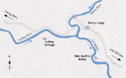 The name Derry Wood (colloquially 'The Derry') is from An Doire – the grove (Watson 1975). Approaching Derry Wood from Linn of Dee – Carn Crom a spur of Derry Cairngorm
is seen directly behind it.
In the Derry Wood is the old Hunting Lodge named Derry Lodge – in spite of the speculation by Dixon and Green (1995) that it ‘was possibly the Head Keeper's house ... A building of one storey and attic, it was suitable for the person second in rank on the estate to the factor’ – local knowledge and existing records (Census records for example) indicate that Ronald McDonald the Head Keeper at the end of the 19th and the start of the 20th centuries lived at Claybokie – and that Derry Lodge was probably intended as temporary accommodation for hunting parties.
The routes through Derry Wood can be confusing – especially when trying to follow a map. Arriving from the direction of Linn Of Dee – the Landrover road leading SW to the Lui Water does not lead to a bridge. Just beyond Derry Lodge another Landrover road leading SW to the Derry Burn does not lead to a bridge either – it once did continuing over the Luibeg Burn towards Luibeg Cottage where Bob Scott
lived for many years.
To continue – straight on – past Derry Lodge crossing Derry Burn by the footbridge and (roughly W) staying close to the North bank of the Luibeg Burn until picking up the Landrover road again.
On the West bank of the Derry Burn – a (roughly N) route leads up Glen Derry to Lairig an Laoigh.
was forfeited in 1716. In Gordon (1925) the author reports that [some] Mackenzie of Dalmore buried his treasure from a raid in Lochaber
beside this tree for a while, before moving it to Cairn Geldie – where it remains to this day.
maps do not show the detour because and earlier bridge spanned the Luibeg Burn here – it was destroyed by a flood, remnants of it can still be seen in the burn near the ford. In Alexander (1928) the author mentions a usable foot bridge being here.
From Preas nam Meirleach the route continues around the base of Carn a' Mhaim
(roughly W) becoming (roughly N) as it approach the junction with the River Dee Route, Corrour Bothy
and the Lairig Ghru
itself.
Glen
A glen is a valley, typically one that is long, deep, and often glacially U-shaped; or one with a watercourse running through such a valley. Whittow defines it as a "Scottish term for a deep valley in the Highlands" that is "narrower than a strath."...
s on the Mar Lodge Estate
Mar Lodge Estate
Mar Lodge Estate is a Scottish Highland estate in Aberdeenshire, owned by the National Trust for Scotland. It is entirely contained within the Cairngorms National Park and important for nature conservation, landscape, recreation and culture.-Geography:...
, in Aberdeenshire
Aberdeenshire
Aberdeenshire is one of the 32 unitary council areas in Scotland and a lieutenancy area.The present day Aberdeenshire council area does not include the City of Aberdeen, now a separate council area, from which its name derives. Together, the modern council area and the city formed historic...
, Scotland.
Its main watercourse
Watercourse
A watercourse is any flowing body of water. These include rivers, streams, anabranches, and so forth.-See also:* physical geography* Environmental flow* Waterway* Hydrology* Wadi-External links:...
is the Lui Water a tributary
Tributary
A tributary or affluent is a stream or river that flows into a main stem river or a lake. A tributary does not flow directly into a sea or ocean...
of the River Dee
River Dee, Aberdeenshire
The River Dee is a river in Aberdeenshire, Scotland. It rises in the Cairngorms and flows through Strathdee to reach the North Sea at Aberdeen...
, which it joins about a half-mile downstream from the Linn of Dee.
Canadian Campsite to Linn of Lui
Known colloquially as the Canadian Campsite – this Lumber Camp was occupied during WWII by Canadian Lumberjacks. The Canadian Campsite covered the corner of land on the East bank of the Lui Water and the North bank of the River Dee and extending northward across the public road – the area is now covered by a PlantationPlantation
A plantation is a long artificially established forest, farm or estate, where crops are grown for sale, often in distant markets rather than for local on-site consumption...
created in the 1980s.
Before the Plantation was created the wartime occupation was evident on the ground with concrete blocks on the surface, partially rotted logs 'nailed' together with ½" spikes. In some of the standing Scots Pine
Scots Pine
Pinus sylvestris, commonly known as the Scots Pine, is a species of pine native to Europe and Asia, ranging from Scotland, Ireland and Portugal in the west, east to eastern Siberia, south to the Caucasus Mountains, and as far north as well inside the Arctic Circle in Scandinavia...
s were mounted insulators for carrying wire – presumably for their telephone system.
Until the Plantation was created the Canadian Campsite was used as a campsite by campers and caravaners. Hillwalkers camped overnight before heading into the Cairngorms
Cairngorms
The Cairngorms are a mountain range in the eastern Highlands of Scotland closely associated with the mountain of the same name - Cairn Gorm.-Name:...
or continuing their journey to Braemar
Braemar
Braemar is a village in Aberdeenshire, Scotland, around west of Aberdeen in the Highlands. It is the closest significantly-sized settlement to the upper course of the River Dee sitting at an altitude of ....
. Some of the caravan owners left their caravans at the Canadian Campsite on a semi-permanent basis with 'regulars' maintaining a weekend and holiday community. Mar Lodge Estate more than tolerated the use of this area as a campsite – they managed the 'rubbish problem' on the campsite by maintaining a rubbish pit – covering it over when full, and digging another nearby.
Also on the Canadian Campsite there was a 'big ditch' apparently man-made, that appeared to have been open to the Lui Water. At its deepest and widest point the ditch was over 10 feet deep, and 20 feet wide. There were many 'spiked' logs at regular intervals along the ditch and perpendicular to its axis.
About a hundred and fifty yards from its confluence with the River Dee, the Lui Water is bridged by a public road at the Linn of Lui. This public road leads (roughly E) towards Mar Lodge
Mar Lodge
Mar Lodge is a sporting lodge, the principal building on the Mar Lodge Estate in Aberdeenshire, Scotland.-Location:Mar Lodge is a sporting lodge built for the use of the Duke and Duchess of Fife...
and Allanaquoich
Allanaquoich
Allanaquoich is a locality on Mar Lodge Estate, Aberdeenshire, Scotland.Allanaquoich is little more than a farm house now although it once could have been described as a hamlet...
, and (roughly W) towards Linn of Dee.
Linn of Lui to Black Bridge
Along the public road (roughly W) one hundred yards or so from the Linn of Lui is a wooden gate across a landrover road that marks the start of one of the main routes from the South to the Lairig GhruLairig Ghru
The Lairig Ghru is one of the mountain passes through the Cairngorms of Scotland.Like many traditional routes the ends of the route through the Lairig Ghru are like the ends of a frayed rope. From the south the Lairig Ghru can be approached from Braemar though Glen Lui, or Glen Dee, and from Blair...
. This route can be followed up Glen Lui following the course of the Lui Water from either the wooden gate at the public road or from the Linn of Dee car park by follow the signposted track through the plantation
Plantation
A plantation is a long artificially established forest, farm or estate, where crops are grown for sale, often in distant markets rather than for local on-site consumption...
. Either way – heading (roughly N) the landrover road leads to the Black Bridge.
In the Lui Water slightly upriver from the bridge are the remains of 'sluices and concrete banks' created by the Canadians in their occupation of the area – Watson (1975).
Black Bridge to Derry Wood
Crossing Black Bridge – turn left (roughly NNW) following the landrover road up Glen Lui and towards The Derry.This part of Glen Lui is a broad glaciated valley dotted with moraines – the remains of the ancient glacial past. Other remains – seen as grassy, roughly rectangular outlines – are those of the townships and farms.
In Gordon (1925) the author laments:
Fortunately for us – in Gordon (1925) and Gordon (1948) the author has done much to record local place-names, and knowledge of the Cairngorms, that would otherwise be lost.
For example – in Gordon (1925) the author gives name to the two moraines of Glen Lui just upriver from Black Bridge – Da Shithean – Two Fairy Mounds.
Clais Fhearniag
A little more than half-a-mile above Black Bridge – just before the burn named Allt a' Mhadaidh on the Ordnance SurveyOrdnance Survey
Ordnance Survey , an executive agency and non-ministerial government department of the Government of the United Kingdom, is the national mapping agency for Great Britain, producing maps of Great Britain , and one of the world's largest producers of maps.The name reflects its creation together with...
1:25 000 maps – a footpath leads up the hillside, and through the narrow valley named Clais Fhearniag – The Hollow of the Alder – the track leads through Clais Fhearniag to Glen Quoich. According to Watson (1975) Clais Fhearniag was created as a result of the Ice Age
Ice age
An ice age or, more precisely, glacial age, is a generic geological period of long-term reduction in the temperature of the Earth's surface and atmosphere, resulting in the presence or expansion of continental ice sheets, polar ice sheets and alpine glaciers...
– the rivers under the ice created by the melting glaciers 'cut the dry cliffed gullies so common in the region' – presumably in some kind of waterfall action.
The Townships
Before the JacobiteJacobite rising
The Jacobite Risings were a series of uprisings, rebellions, and wars in Great Britain and Ireland occurring between 1688 and 1746. The uprisings were aimed at returning James VII of Scotland and II of England, and later his descendants of the House of Stuart, to the throne after he was deposed by...
Rising of 1715 Glen Lui supported many people and the valley floor was dotted with farms and townships. Following the acquisition of the forfeited Mar Estate
Mar Lodge Estate
Mar Lodge Estate is a Scottish Highland estate in Aberdeenshire, owned by the National Trust for Scotland. It is entirely contained within the Cairngorms National Park and important for nature conservation, landscape, recreation and culture.-Geography:...
by James Erskine, Lord Grange and David Erskine, Lord Dun
David Erskine, Lord Dun
David Erskine, Lord Dun , was a Scottish judge and MP.Erskine, son of David Erskine of Dun, near Montrose, Forfarshire, studied at the universities of St. Andrews and of Paris. He became a member of the Scottish bar on 19 November 1698, and soon rose to eminence...
in 1724 the 'Farmers of Glen Lui were forcibly evicted in 1726' – Watson (1975).
In Gordon (1948) the author quotes from a letter dated 15 September 1726 from Lord Grange to James Farquharson of Balmoral who was Factor and Forester of the estate at the time, referring to Glen Lui and instructing him to eject those people after their harvest is over. The reason for this clearance appears to have been economic, to make timber extraction from the glen easier. In any case the glen appears to have been resettled by 1732, and finally cleared again by 1777 by which time all the tenancies in Glen Lui had reverted to the landowner – Earl Fife
James Duff, 2nd Earl Fife
James Duff, 2nd Earl Fife was a Scottish Earl, Baron and Minister of Parliament.-Heritage:James Duff was second son of William Duff, 1st Earl Fife, and Jean Grant , his fathers second wife. His father, son of William Duff of Dipple, co. Banff, was M.P...
– Dixon and Green (1995).
Some old maps show place names in the glen, but do not fix locations accurately. To the north of the Lui Water – Roy (1747–1755) shows : Achavadie, Aldvattigally, and Rinton, and to the south : Dalgirmich, and Knockinted – showing that these place names (at least) existed in Glen Lui before 1755. Although these place names appear to be phonetic transcriptions of the Gaelic there is no great difficulty in connecting these phonetic-transcriptions with the actual place names they represent.
Similarly to the north Dixon and Green (1995) shows : Wester Auchavrie, Easter Auchavrie, Croislish, Allt a' Mhadaidh-allaidh, and Ruigh an t-Sidhein, and to the south : Dail Rosaigh, Dail Gainimh, and Cnoc na Teididh.
However – in Gordon (1925) the author gives the name of the burn as Allt a' Mhadaidh Allaidh – the Wolf's Burn, commemorating the killing of the last Wolf in the Forest of Mar. In Watson (1975) the author gives its name as Allt Mhad-allaidh and the pronunciation as like Vat Aalie.
In Gordon (1948) the author suggest the township named Aldvattigally by Roy (1747–1755), and Allt a' Mhadaidh-allaidh by Dixon and Green (1995) should be Allt a' Mhadaidh Allaidh – Burn of the Wild Dog (Wolf), and the township named Achavadie by Roy (1747–1755), and the Wester and Easter Auchavrie by Dixon and Green (1995) should be Ach' a' Mhaidaidh – Field of the Dog.
Derry Wood
Derry Cairngorm
Derry Cairngorm is a Scottish mountain in the Cairngorms range, 14 kilometres north west of Braemar in the county of Aberdeenshire.- Overview :...
is seen directly behind it.
In the Derry Wood is the old Hunting Lodge named Derry Lodge – in spite of the speculation by Dixon and Green (1995) that it ‘was possibly the Head Keeper's house ... A building of one storey and attic, it was suitable for the person second in rank on the estate to the factor’ – local knowledge and existing records (Census records for example) indicate that Ronald McDonald the Head Keeper at the end of the 19th and the start of the 20th centuries lived at Claybokie – and that Derry Lodge was probably intended as temporary accommodation for hunting parties.
The routes through Derry Wood can be confusing – especially when trying to follow a map. Arriving from the direction of Linn Of Dee – the Landrover road leading SW to the Lui Water does not lead to a bridge. Just beyond Derry Lodge another Landrover road leading SW to the Derry Burn does not lead to a bridge either – it once did continuing over the Luibeg Burn towards Luibeg Cottage where Bob Scott
Robert Scott (Deer Stalker)
Robert 'Bob' Lane Scott was probably the best known deer stalker on Mar Lodge Estate, in Aberdeenshire, Scotland.The son of Donald Scott and his wife Elizabeth Birnie , Bob was born in Linn of Dee Cottage, attended the school at Inverey, and worked as a Deer Stalker, all on Mar Lodge Estate.In...
lived for many years.
To continue – straight on – past Derry Lodge crossing Derry Burn by the footbridge and (roughly W) staying close to the North bank of the Luibeg Burn until picking up the Landrover road again.
On the West bank of the Derry Burn – a (roughly N) route leads up Glen Derry to Lairig an Laoigh.
Glen Luibeg
Glen Luibeg starts – perhaps – at the confluence of Derry Burn with Lui Water. If so – Luibeg Burn starts at this point too. From here the route is in Glen Luibeg along the northern bank of Luibeg Burn. The landrover road used to cross the bridge at Derry Lodge pass Luibeg Cottage then crossing Luibeg Burn and leading all the way to Preas nam Meirleach – Robber's Copse : Watson (1975). The route from Luibeg has recently been improved and narrowed, and is no longer regularly driven over by vehicles.Coire Craobh an Oir
Just west of Luibeg on the south facing slope of Carn Crom is the shallow corrie named Coire Craobh an Oir – corrie of the tree of gold : Watson (1975). The legend attached to the name reported in (among others) Gordon (1925) and Watson (1975) relates to one of the Mackenzies who held Dalmore – the name of the building and locality where the present Mar Lodge stands. Generations of Mackenzies were feudal-holders of Dalmore under the Earls of Mar until Mar Lodge EstateMar Lodge Estate
Mar Lodge Estate is a Scottish Highland estate in Aberdeenshire, owned by the National Trust for Scotland. It is entirely contained within the Cairngorms National Park and important for nature conservation, landscape, recreation and culture.-Geography:...
was forfeited in 1716. In Gordon (1925) the author reports that [some] Mackenzie of Dalmore buried his treasure from a raid in Lochaber
Lochaber
District of Lochaber 1975 to 1996Highland council area shown as one of the council areas of ScotlandLochaber is one of the 16 ward management areas of the Highland Council of Scotland and one of eight former local government districts of the two-tier Highland region...
beside this tree for a while, before moving it to Cairn Geldie – where it remains to this day.
Preas nam Meirleach
At Preas nam Meirleach the Luibeg Burn cuts across the footpath forcing a fording or detour upstream to the Luibeg Bridge. The older 7th series Ordnance SurveyOrdnance Survey
Ordnance Survey , an executive agency and non-ministerial government department of the Government of the United Kingdom, is the national mapping agency for Great Britain, producing maps of Great Britain , and one of the world's largest producers of maps.The name reflects its creation together with...
maps do not show the detour because and earlier bridge spanned the Luibeg Burn here – it was destroyed by a flood, remnants of it can still be seen in the burn near the ford. In Alexander (1928) the author mentions a usable foot bridge being here.
From Preas nam Meirleach the route continues around the base of Carn a' Mhaim
Càrn a' Mhàim
Càrn a' Mhàim is a Scottish mountain situated in the inner part of the Cairngorms range, some 15 kilometres west of Braemar in the county of Aberdeenshire.- Overview :...
(roughly W) becoming (roughly N) as it approach the junction with the River Dee Route, Corrour Bothy
Corrour Bothy
Corrour Bothy is a simple stone building on Mar Lodge Estate, Aberdeenshire, Scotland.It is located below Coire Odhar between The Devil's Point and Cairn Toul on the western side of the River Dee in the Lairig Ghru....
and the Lairig Ghru
Lairig Ghru
The Lairig Ghru is one of the mountain passes through the Cairngorms of Scotland.Like many traditional routes the ends of the route through the Lairig Ghru are like the ends of a frayed rope. From the south the Lairig Ghru can be approached from Braemar though Glen Lui, or Glen Dee, and from Blair...
itself.