

Lairig Ghru
Encyclopedia
Mountain pass
A mountain pass is a route through a mountain range or over a ridge. If following the lowest possible route, a pass is locally the highest point on that route...
es through the Cairngorms
Cairngorms
The Cairngorms are a mountain range in the eastern Highlands of Scotland closely associated with the mountain of the same name - Cairn Gorm.-Name:...
of Scotland
Scotland
Scotland is a country that is part of the United Kingdom. Occupying the northern third of the island of Great Britain, it shares a border with England to the south and is bounded by the North Sea to the east, the Atlantic Ocean to the north and west, and the North Channel and Irish Sea to the...
.
Like many traditional routes the ends of the route through the Lairig Ghru are like the ends of a frayed rope. From the south the Lairig Ghru can be approached from Braemar
Braemar
Braemar is a village in Aberdeenshire, Scotland, around west of Aberdeen in the Highlands. It is the closest significantly-sized settlement to the upper course of the River Dee sitting at an altitude of ....
though Glen Lui
Glen Lui
Glen Lui from Gleann Laoigh – calves' glen – Gordon is one of the major glens on the Mar Lodge Estate, in Aberdeenshire, Scotland.Its main watercourse is the Lui Water a tributary of the River Dee, which it joins about a half-mile downstream from the Linn of Dee.-Canadian Campsite to Linn of...
, or Glen Dee, and from Blair Atholl
Blair Atholl
Blair Atholl is a small town in Perthshire, Scotland, built about the confluence of the Rivers Tilt and Garry in one of the few areas of flat land in the midst of the Grampian Mountains. The Gaelic place-name Blair, from blàr, 'field, plain', refers to this location...
through Glen Tilt
Glen Tilt
Glen Tilt is a glen in the extreme north of Perthshire, Scotland. Beginning at the confines of Aberdeenshire, it follows a South-westerly direction excepting for the last 4 miles, when it runs due south to Blair Atholl...
. From the north the Lairig Ghru can be approached from Glen More through the Chalamain Gap, and from Aviemore
Aviemore
Aviemore is a town and tourist resort, situated within the Cairngorms National Park in the Highlands of Scotland. It is in the Badenoch and Strathspey committee area, within the Highland council area. The town is popular for skiing and other winter sports, and for hill-walking in the Cairngorm...
through the Rothiemurchus Forest
Rothiemurchus Forest
Rothiemurchus Forest is a remnant of the Caledonian Forest at near Aviemore, Badenoch and Strathspey, Highland, Scotland.The forest is popular for recreation, but contains some of the most important wildlife in Europe, including the osprey, Scottish crossbill, capercaillie, crested tit and wild...
by way of the Crossroads above Allt Druidh.
Name
In Watson (1975) the author plausibly explains the derivation of Lairig Ghru as a place-name. He gives Lairig Dhru with the local pronunciation of Laarig Groo and the meaning pass of Dhru or Druie suggesting the ‘probable’ derivation from Drudhadh meaning oozing. Any visitor to the summit of the Lairig Ghru would accept that as a possible derivation because two watercourses - one on each side of the summit - actually appear to ooze from the valley floor.However - in Gordon (1948) the author is much less certain about the derivation of the place-name - writing:
The weight of suggestion is - therefore - that Lairig Ghru is certainly the hill pass (of something) and that something is probably related to the water flowing from the floor of the valley close to the summit.
Many gaelic place names have lost their original spelling and meaning through translation into English. The prolific and late Dundonian mountaineer, Syd Scroggie felt that the name Lairig Ghru was such a case and suggested in his book, "The Cairngorms Unseen" that the Lairig Ghru, was actually in fact the Lairig Ruadh (Red Pass). This fits with the original name of the mountain range Am Monadh Ruadh, (The Red Mountains).
History
Historically the Lairig Ghru has been used simply as a route between Deeside and StrathspeyStrathspey, Scotland
Strathspey is the area around the strath of the River Spey, Scotland, in both the Moray council area and the Badenoch and Strathspey committee area of Highland....
by anyone needing to make that journey. It is often referred to as a Drove Road, and while it's not wrong to do so, it is arguably an overemphasisation of one specific use to do so. The Lairig Ghru has been a route used by many different people, for many different purposes as made clear in Haldane (1952), and was in regular use long before the height of the droving trade in the more peaceful times after the middle of the 18th century:
The Lairig Ghru was used as a droving-route as late as 1873 - Haldane (1952) - to Braemar and farther south. Until approximately the 1870's men from Rothiemurchus annually, in the spring, cleared the track of rocks that had fallen on to it during the winter.
Modern road traffic now travels over the Drumochter Pass via the A9 or The Lecht on the A939
A939 road
The A939 'Lecht Road' connects the A96 at Nairn on the Moray Coast with the A95 Grantown on Spey, then it continues to the A93 at Ballater by way of the Grampian Mountains, passing Tomintoul and the Lecht Ski Centre.This road passes over four summits:...
, and the Lairig Ghru is left to walkers
Hillwalking
In the British Isles, the terms hillwalking or fellwalking are commonly used to describe the recreational outdoor activity of walking on hills and mountains, often with the intention of visiting their summits...
.
The full route from Aviemore
Aviemore
Aviemore is a town and tourist resort, situated within the Cairngorms National Park in the Highlands of Scotland. It is in the Badenoch and Strathspey committee area, within the Highland council area. The town is popular for skiing and other winter sports, and for hill-walking in the Cairngorm...
to Braemar
Braemar
Braemar is a village in Aberdeenshire, Scotland, around west of Aberdeen in the Highlands. It is the closest significantly-sized settlement to the upper course of the River Dee sitting at an altitude of ....
is about 43 km, though many walkers cut the walk short by starting or finishing at Linn of Dee, the 8 km from there to Braemar being along a tarmaced
Tarmac
Tarmac is a type of road surface. Tarmac refers to a material patented by Edgar Purnell Hooley in 1901...
road.
Recreational use
Although the Lairig Ghru has long been used by ‘travellers‘ to get between Strathspey and Deeside, it has also been used recreationally since at least the early twentieth century Anderson (1911) writes:An even earlier recreational mention CCJ 17, July 1901 is a report on the snow conditions in the Lairig Ghru by C. G. Cash in April of that year - he writes:
This snow report by C. G. Cash implies a familiarity with the Lairig Ghru - both his own, and his readers.
Way Points (from the south)
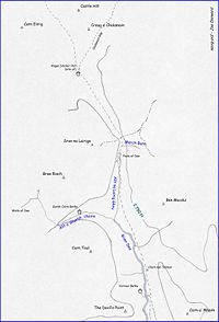
There is no objective measure of where the ends of the Lairig Ghru are. In Gordon (1948) the author defines Lairig as meaning a Hill Pass - in that case - the landscape is arguable too open for the ‘ends’ of the Lairig's track to extend much beyond the imaginary lines drawn between the summits of Carn a' Mhaim
Càrn a' Mhàim
Càrn a' Mhàim is a Scottish mountain situated in the inner part of the Cairngorms range, some 15 kilometres west of Braemar in the county of Aberdeenshire.- Overview :...
and The Devil's Point
The Devil's Point
The Devil's Point is a mountain in the Cairngorms of Scotland, lying to the west of the Lairig Ghru pass. The name is derived from Gaelic, meaning "Penis of the Demon". The English name is a result of a visit to the area by Queen Victoria...
at the southern end - and Carn Eilrig and Castle Hill at the northern end.
From the south - the two main approaches to the Lairig Ghru follow the Glen Lui Route
Glen Lui
Glen Lui from Gleann Laoigh – calves' glen – Gordon is one of the major glens on the Mar Lodge Estate, in Aberdeenshire, Scotland.Its main watercourse is the Lui Water a tributary of the River Dee, which it joins about a half-mile downstream from the Linn of Dee.-Canadian Campsite to Linn of...
or the Glen Dee Route - these two routes come together soon after crossing the imaginary line between Carn a' Mhaim
Càrn a' Mhàim
Càrn a' Mhàim is a Scottish mountain situated in the inner part of the Cairngorms range, some 15 kilometres west of Braemar in the county of Aberdeenshire.- Overview :...
and The Devil's Point
The Devil's Point
The Devil's Point is a mountain in the Cairngorms of Scotland, lying to the west of the Lairig Ghru pass. The name is derived from Gaelic, meaning "Penis of the Demon". The English name is a result of a visit to the area by Queen Victoria...
creating the first way-point. Soon after this coming together - the track splits again with the left-hand (roughly NW) branch leading to the Cairngorm Club footbridge across the River Dee towards Corrour Bothy and the mountains to the west of the Lairig Ghru.
Corrour Bothy
A Mountain Refuge maintained by the Mountain Bothy Association - see independent article Corrour BothyCorrour Bothy
Corrour Bothy is a simple stone building on Mar Lodge Estate, Aberdeenshire, Scotland.It is located below Coire Odhar between The Devil's Point and Cairn Toul on the western side of the River Dee in the Lairig Ghru....
.
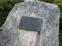
Clach nan Taillear
Literally - stone of the tailors - Watson (1975) is a large ribbed stone by the side of the Lairig Ghru track close to where the Allt Coire an t-Saighdeir joins the River Dee.In Gordon (1948) the author gives the story of how this stone got its name - writing:
River Dee
Although all the rain that falls on the slopes at either side of the Lairig Ghru eventually drains into the River Dee - and the ‘official’ sourceSource (river or stream)
The source or headwaters of a river or stream is the place from which the water in the river or stream originates.-Definition:There is no universally agreed upon definition for determining a stream's source...
of the River Dee - the Wells of Dee - are high on Braeriach
Braeriach
Braeriach is the third highest mountain in Great Britain, surpassed only by Ben Nevis and Ben Macdui. It is the highest point in the western massif of the Cairngorms, separated from the central section by the pass of the Lairig Ghru. The summit has a crescent shape, with several corries...
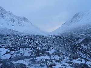
; the River Dee - as a named watercourse on maps - starts at the confluence of Allt a' Gharbh choirie and Allt na Lairig Ghru near the head of Glen Dee. At this point - the main valley turns roughly west towards An Garbh Choire, and the Lairig Ghru track continues northward into the hanging valley as shown in the photograph in the gallery.
The Duke's Path
Only shown on the 1:25 000 scale maps - The Duke's Path is a made-path on the western side of the Lairig Ghru following the course of the burn draining Coire Ruadh, and leading to the bealach between Braeriach and Sron na Lairige.During the nineteenth century - what was then Mar Estate was a private hunting estate owned by the Duke of Fife
Alexander Duff, 1st Duke of Fife
Alexander William George Duff, 1st Duke of Fife KG, KT, GCVO, PC, VD , styled Viscount Macduff between 1857 and 1879 and known as The Earl Fife between 1879 and 1889, was a British Peer who married Princess Louise of Wales, the third child and eldest daughter of King Edward VII and Alexandra of...
(created Duke in 1889, and dying in 1912). In Gordon (1925) the author describes using this path on an ascent of Braeriach - continuing:
Pools of Dee
A series of pools on the Mar side of the summit that the Lairig Ghru track winds around - thought by many (incorrectly) to be the source of the River Dee - understandable when in Watson (1975) the author explains that The Pools of Dee are an invention rather than a pure Anglicisation of the old name of Lochan Dubh na Lairige - black tarn of the Lairig.At least one of these pools is reputed to contain trout in spite of these pools having no obvious outflow, nor inflow. Slightly to the south of the largest pool - the burn named Allt na Lairig Ghru flows from the floor of the valley flowing south to join with the burn named Allt a' Gharbh choirie to create the River Dee proper.
March Burn
The March Burn is a burn on the Mar side of the summit of the Lairig Ghru draining the eastern-slope above it and disappearing below the rocks before it reaches the floor of the valley. In Gordon (1925) the author describes it as falling in a white spray to the Lairig from the northern spur of Ben Mac Dhui.This use of March has nothing to do with the month of the year, but refers to the old use of the word meaning boundary. The summit of the Lairig Ghru marks the boundary between Deeside (Aberdeenshire) and Strathspey (Inverness-shire). In Watson (1975) the author gives the old name of Allt na Criche - the burn of the boundary giving the local pronunciation as Creech.
Summit
In Watson (1975) the author gives the summit as about 835 metres, and the Cairngorm Tourist Map (1975) gives a spot-height of 2,733 feet.Angus Sinclair Memorial Hut (site of)
Cairn Gorm
Cairn Gorm is a mountain in the Scottish Highlands overlooking Strathspey and the town of Aviemore. At 1245 metres it is the sixth highest mountain in the United Kingdom...
on December 21, 1954. Like many other man-made shelters in the mountains of Scotland that were very accessible from public roads, it was demolished and removed in about 1991.
The refuge was located near the cross-roads where the tracks from Sron na Lairige and the Chalamain Gap cross the Lairig Ghru.
Chalamain Gap
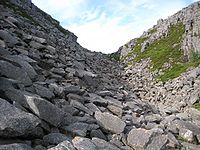
Ravine
A ravine is a landform narrower than a canyon and is often the product of streamcutting erosion. Ravines are typically classified as larger in scale than gullies, although smaller than valleys. A ravine is generally a fluvial slope landform of relatively steep sides, on the order of twenty to...
used as a route between the Lairig Ghru and Glen More.
Evidently the name Chalamain Gap has been applied relatively recently to this ravine, since in Alexander (1928) the author does not name the gap, but describes it - writing:
In Watson (1975) the author does not name the ravine Chalamain Gap either, but referring to it in the context of the location of the Sinclair Hut - writes:
More recently - Diack (2006) gives the name as Eag Coire na Comhdhalack - The Ravine of the Corrie of the Assembly.