

Gleeson, Arizona
Encyclopedia
Gleeson is a ghost town
in Cochise County
in the southeastern section of the U.S. state
of Arizona
. The town was first settled as Turquoise around 1890 in what was then the Arizona Territory
, then later re-established as Gleeson in 1900.
 The area was initially settled as a mining camp called Turquoise
after the mineral which had been mined by Native Americans
in the area. The Turquoise post office was established on October 22, 1890, and lasted only a few years until September 17, 1894. When local miner John Gleeson registered a copper claim and opened the Copper Belle Mine, the town of Gleeson was created just downhill from the old site of Turquoise. Silver Bill, Pejon and Defiance were some of the other mines that followed in the surrounding areas.
The Gleeson post office, established on October 15, 1900, supported a town of about 500 people engaged primarily in copper
mining, including veins of lead
, silver
and zinc
.
In 1912 a fire consumed 28 buildings and the town was rebuilt.
Copper production boomed to supply demand World War I
. The mines played out by the 1930s and eventually the Gleeson post office closed on March 31, 1939.
, with the only commercial venture appearing to be a rattlesnake products store. Visitors can find the ruins of a hospital, a saloon, a jail, the foundation of the village school and evidence of the extensive mining in the surrounding hills near town. The Gleeson cemetery is west of the town on the road to Tombstone
.
on the southern slopes of the Dragoon Mountains
at 31°44′02"N 109°49′47"W (31.7339802, -109.8297941).
Ghost town
A ghost town is an abandoned town or city. A town often becomes a ghost town because the economic activity that supported it has failed, or due to natural or human-caused disasters such as floods, government actions, uncontrolled lawlessness, war, or nuclear disasters...
in Cochise County
Cochise County, Arizona
-2010:Whereas according to the 2010 U.S. Census Bureau:*78.5% White*4.2% Black*1.2% Native American*1.9% Asian*0.3% Native Hawaiian or Pacific Islander*4.0% Two or more races*9.6% Other races*32.4% Hispanic or Latino -2000:...
in the southeastern section of the U.S. state
U.S. state
A U.S. state is any one of the 50 federated states of the United States of America that share sovereignty with the federal government. Because of this shared sovereignty, an American is a citizen both of the federal entity and of his or her state of domicile. Four states use the official title of...
of Arizona
Arizona
Arizona ; is a state located in the southwestern region of the United States. It is also part of the western United States and the mountain west. The capital and largest city is Phoenix...
. The town was first settled as Turquoise around 1890 in what was then the Arizona Territory
Arizona Territory
The Territory of Arizona was an organized incorporated territory of the United States that existed from February 24, 1863 until February 14, 1912, when it was admitted to the Union as the 48th state....
, then later re-established as Gleeson in 1900.
History
Turquoise
Turquoise is an opaque, blue-to-green mineral that is a hydrous phosphate of copper and aluminium, with the chemical formula CuAl648·4. It is rare and valuable in finer grades and has been prized as a gem and ornamental stone for thousands of years owing to its unique hue...
after the mineral which had been mined by Native Americans
Indigenous peoples of the Americas
The indigenous peoples of the Americas are the pre-Columbian inhabitants of North and South America, their descendants and other ethnic groups who are identified with those peoples. Indigenous peoples are known in Canada as Aboriginal peoples, and in the United States as Native Americans...
in the area. The Turquoise post office was established on October 22, 1890, and lasted only a few years until September 17, 1894. When local miner John Gleeson registered a copper claim and opened the Copper Belle Mine, the town of Gleeson was created just downhill from the old site of Turquoise. Silver Bill, Pejon and Defiance were some of the other mines that followed in the surrounding areas.
The Gleeson post office, established on October 15, 1900, supported a town of about 500 people engaged primarily in copper
Copper
Copper is a chemical element with the symbol Cu and atomic number 29. It is a ductile metal with very high thermal and electrical conductivity. Pure copper is soft and malleable; an exposed surface has a reddish-orange tarnish...
mining, including veins of lead
Lead
Lead is a main-group element in the carbon group with the symbol Pb and atomic number 82. Lead is a soft, malleable poor metal. It is also counted as one of the heavy metals. Metallic lead has a bluish-white color after being freshly cut, but it soon tarnishes to a dull grayish color when exposed...
, silver
Silver
Silver is a metallic chemical element with the chemical symbol Ag and atomic number 47. A soft, white, lustrous transition metal, it has the highest electrical conductivity of any element and the highest thermal conductivity of any metal...
and zinc
Zinc
Zinc , or spelter , is a metallic chemical element; it has the symbol Zn and atomic number 30. It is the first element in group 12 of the periodic table. Zinc is, in some respects, chemically similar to magnesium, because its ion is of similar size and its only common oxidation state is +2...
.
In 1912 a fire consumed 28 buildings and the town was rebuilt.
Copper production boomed to supply demand World War I
World War I
World War I , which was predominantly called the World War or the Great War from its occurrence until 1939, and the First World War or World War I thereafter, was a major war centred in Europe that began on 28 July 1914 and lasted until 11 November 1918...
. The mines played out by the 1930s and eventually the Gleeson post office closed on March 31, 1939.
Remnants
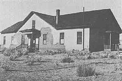
Though several families still live on the site, Gleeson is, by all measures, a ghost townGhost town
A ghost town is an abandoned town or city. A town often becomes a ghost town because the economic activity that supported it has failed, or due to natural or human-caused disasters such as floods, government actions, uncontrolled lawlessness, war, or nuclear disasters...
, with the only commercial venture appearing to be a rattlesnake products store. Visitors can find the ruins of a hospital, a saloon, a jail, the foundation of the village school and evidence of the extensive mining in the surrounding hills near town. The Gleeson cemetery is west of the town on the road to Tombstone
Tombstone, Arizona
Tombstone is a city in Cochise County, Arizona, United States, founded in 1879 by Ed Schieffelin in what was then Pima County, Arizona Territory. It was one of the last wide-open frontier boomtowns in the American Old West. From about 1877 to 1890, the town's mines produced USD $40 to $85 million...
.
Geography
Gleeson is located 16 miles (25.7 km) east of TombstoneTombstone, Arizona
Tombstone is a city in Cochise County, Arizona, United States, founded in 1879 by Ed Schieffelin in what was then Pima County, Arizona Territory. It was one of the last wide-open frontier boomtowns in the American Old West. From about 1877 to 1890, the town's mines produced USD $40 to $85 million...
on the southern slopes of the Dragoon Mountains
Dragoon Mountains
Dragoon Mountains are a range of mountains located in Cochise County, Arizona. The range is about 25 mi long, running on an axis extending south-south east through Willcox.- Geography :...
at 31°44′02"N 109°49′47"W (31.7339802, -109.8297941).
External links
- Arizona Ghost Town Trails entry for Gleeson.
- Ghost Town Gallery with images of Gleeson, AZ. as well as other ghost towns throughout the American west.
- Ghost Town of the Month entry for Gleeson: recent photos and visitor information.
- Ghosttown.com entry for Gleeson.
- http://www.GleesonArizona.com/index.html Site dedicated to Gleeson information and history.