
Georgia State Route 47
Encyclopedia
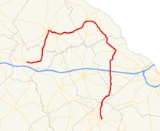
State Route 47 is a bizarre, arc-shaped state route located in the eastern part of the U.S. state
of Georgia
. The route travels from U.S. Route 278
/State Route 12 in Crawfordville
to U.S. Route 1
/State Route 4 in Wrens
.
, where it makes a drastic turn to the north. The route continues north to Washington
, where it briefly cosigns
with U.S. Route 78 Business east, then becomes cosigned with U.S. Route 378
east to Lincolnton
. The route departs Lincolnton to the southeast, and crosses a long causeway and bridge over an arm of Strom Thurmond Lake before entering Columbia County
. At Pollards Corner, State Route 47 becomes cosigned with U.S. Route 221
. The two routes travel south through Appling
, meet Interstate 20
south of Appling, and continue south, skirting the western edge of Fort Gordon
before arriving in Wrens. In Wrens, State Route 47 meets its clockwise terminus at U.S. Route 1/State Route 4, while U.S. Route 221 continues south, cosigned with U.S. Route 1.
State Route 47 serves mostly to connect county seats in eastern Georgia, rather than to serve as a long-distance through route. As such, it sees an Average Annual Daily Traffic of less than 5,000 vehicles except for a small segment in downtown Washington.
.
U.S. state
A U.S. state is any one of the 50 federated states of the United States of America that share sovereignty with the federal government. Because of this shared sovereignty, an American is a citizen both of the federal entity and of his or her state of domicile. Four states use the official title of...
of Georgia
Georgia (U.S. state)
Georgia is a state located in the southeastern United States. It was established in 1732, the last of the original Thirteen Colonies. The state is named after King George II of Great Britain. Georgia was the fourth state to ratify the United States Constitution, on January 2, 1788...
. The route travels from U.S. Route 278
U.S. Route 278
U.S. Route 278 is a parallel route of U.S. Route 78. It currently runs for 1,074 miles from Hilton Head Island, South Carolina to Wickes, Arkansas at U.S. Highway 71/U.S. Highway 59. It might be notable that it is longer than its parent highway, US Hwy-78. US Hwy-278 passes through the states of...
/State Route 12 in Crawfordville
Crawfordville, Georgia
Crawfordville is a city in Taliaferro County, Georgia, United States. The population was 572 at the 2000 census. The city is the county seat of Taliaferro County.-Geography:Crawfordville is located at ....
to U.S. Route 1
U.S. Route 1
U.S. Route 1 is a major north–south U.S. Highway that serves the East Coast of the United States. It runs 2,377 miles from Fort Kent, Maine at the Canadian border south to Key West, Florida. U.S. 1 generally parallels Interstate 95, though it is significantly farther west between...
/State Route 4 in Wrens
Wrens, Georgia
Wrens is a city in Jefferson County, Georgia, United States. The population was 2,187 at the 2010 census.-Geography:Wrens is located at .According to the United States Census Bureau, the city has a total area of , of which, of it is land and 0.33% is water.-Demographics:As of the census of 2000,...
.
Route description
From its counterclockwise terminus at U.S. Route 278/State Route 12 in Crawfordville, State Route 47 travels east to SharonSharon, Georgia
Sharon is a city in Taliaferro County, Georgia, United States. The population was 105 at the 2000 census.-History:The community of Sharon is visible on maps as early as 1865. Its residents incorporated as a city in 1884...
, where it makes a drastic turn to the north. The route continues north to Washington
Washington, Georgia
Washington is a city in Wilkes County, Georgia, United States. The population was 4,295 at the 2000 census. The city is the county seat of Wilkes County...
, where it briefly cosigns
Concurrency (road)
A concurrency, overlap, or coincidence in a road network is an instance of one physical road bearing two or more different highway, motorway, or other route numbers...
with U.S. Route 78 Business east, then becomes cosigned with U.S. Route 378
U.S. Route 378
U.S. Route 378 is a spur of U.S. Route 78. It currently runs for 234 miles from Conway, South Carolina at U.S. Route 501 to Washington, Georgia at U.S. Route 78.-Route description:...
east to Lincolnton
Lincolnton, Georgia
Lincolnton is a city in and the county seat of Lincoln County, Georgia, United States. The population was 1,595 at the 2000 census. It is the location for the historical site, Elijah Clark State Park, and contains numerous houses and historic districts listed on the National Register of Historic...
. The route departs Lincolnton to the southeast, and crosses a long causeway and bridge over an arm of Strom Thurmond Lake before entering Columbia County
Columbia County, Georgia
Columbia County is a county located in the US state of Georgia along the Savannah River. As of 2010 the population was 124,054 a growth of 39% from the 2000 census figure of 89,288. The de jure county seat is Appling. Appling is an unincorporated area, making Columbia one of only three counties...
. At Pollards Corner, State Route 47 becomes cosigned with U.S. Route 221
U.S. Route 221
U.S. Route 221 is a spur of U.S. Route 21. It runs for 734 miles from Perry, Florida at US Routes 19/98/ALT 27 to Lynchburg, Virginia at U.S. Route 29 . It passes through the states of Florida, Georgia, South Carolina, North Carolina, and Virginia...
. The two routes travel south through Appling
Appling, Georgia
Appling is an unincorporated community in and the county seat of Columbia County, Georgia, United States. It is part of the Augusta, Georgia metropolitan area....
, meet Interstate 20
Interstate 20 in Georgia
In Georgia, Interstate 20 runs from the Alabama border to the Savannah River, which the Georgia-South Carolina border straddles. It passes through the heavily congested Atlanta metropolitan area and exits the state at Augusta...
south of Appling, and continue south, skirting the western edge of Fort Gordon
Fort Gordon
Fort Gordon, formerly known as Camp Gordon, is a United States Army installation established in 1917. It is the current home of the United States Army Signal Corps and Signal Center and was once the home of "The Provost Marshal General School" . The fort is located in Richmond, Jefferson, McDuffie,...
before arriving in Wrens. In Wrens, State Route 47 meets its clockwise terminus at U.S. Route 1/State Route 4, while U.S. Route 221 continues south, cosigned with U.S. Route 1.
State Route 47 serves mostly to connect county seats in eastern Georgia, rather than to serve as a long-distance through route. As such, it sees an Average Annual Daily Traffic of less than 5,000 vehicles except for a small segment in downtown Washington.
Related route
State Route 47 Connector is a very short connector route in Wilkes CountyWilkes County, Georgia
Wilkes County is a county located in the U.S. state of Georgia. As of 2000, the population was 10,687. The 2007 Census estimate shows a population of 10,262. The county seat is the city of Washington. Referred to as "Washington-Wilkes", the county seat and county are commonly treated as a...
.