
Georgia State Route 29
Encyclopedia
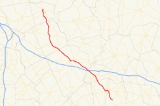
State Route 29 is a north–south state route located in the central part of the U.S. state
of Georgia
. The route travels from US 1
/SR 4 south of Lyons
northwest to SR 24
north of Milledgeville
.
with SR 15 to Vidalia
. After heading west, briefly cosigned with US 280
/SR 30, State Routes 29 and 15 continue northwest to Soperton
. SR 29 splits from SR 15, and continues northwest from Soperton, and meets Interstate 16
northwest of the city at exit 67. Continuing northwest, the route becomes cosigned with State Route 86 to US 80
/SR 26, where SR 86 meets its northern terminus. SR 29, however, becomes cosigned with US 80/SR 26, and eventually, US 319
/SR 31, west to Dublin
. In Dublin, SR 29 departs the other routes and travels northwest, cosigned with US 441
. North of Milledgeville, SR 24 intersects the route, and continues north cosigned with US 441, while SR 29 meets its northern terminus.
State Route 29 runs mostly in rural areas, and sees minor traffic, except around Vidalia, Soperton, Dublin and Milledgeville.
U.S. state
A U.S. state is any one of the 50 federated states of the United States of America that share sovereignty with the federal government. Because of this shared sovereignty, an American is a citizen both of the federal entity and of his or her state of domicile. Four states use the official title of...
of Georgia
Georgia (U.S. state)
Georgia is a state located in the southeastern United States. It was established in 1732, the last of the original Thirteen Colonies. The state is named after King George II of Great Britain. Georgia was the fourth state to ratify the United States Constitution, on January 2, 1788...
. The route travels from US 1
U.S. Route 1
U.S. Route 1 is a major north–south U.S. Highway that serves the East Coast of the United States. It runs 2,377 miles from Fort Kent, Maine at the Canadian border south to Key West, Florida. U.S. 1 generally parallels Interstate 95, though it is significantly farther west between...
/SR 4 south of Lyons
Lyons, Georgia
Lyons is a city in Toombs County, Georgia, United States. The population was 4,169 at the 2000 census. The city is the county seat of Toombs County.Lyons is part of the Vidalia Micropolitan Statistical Area.-Geography:...
northwest to SR 24
State Route 24 (Georgia)
State Route 24 is a state highway in the U.S. state of Georgia. It runs from State Route 15 north of Watkinsville south to Milledgeville along U.S. Highway 441, east to Waynesboro, and southeast and southwest to end at State Route 26/U.S. Highway 80 in Statesboro.Initially SR 24 ran from...
north of Milledgeville
Milledgeville, Georgia
Milledgeville is a city in and the county seat of Baldwin County in the U.S. state of Georgia. It is northeast of Macon, located just before Eatonton on the way to Athens along U.S. Highway 441, and it is located on the Oconee River. The relatively rapid current of the Oconee here made this an...
.
Route description
From its southern terminus at US 1/SR 4 south of Lyons, State Route 29 travels northwest cosignedConcurrency (road)
A concurrency, overlap, or coincidence in a road network is an instance of one physical road bearing two or more different highway, motorway, or other route numbers...
with SR 15 to Vidalia
Vidalia, Georgia
Vidalia, is a city in Toombs and very slightly into Montgomery counties in the U.S. state of Georgia. As of the 2000 census, the city population was 10,491. It is the largest city in Toombs, but is not the county seat...
. After heading west, briefly cosigned with US 280
U.S. Route 280
U.S. Route 280 is a spur of U.S. Highway 80. It currently runs for 392 miles from Blichton, Georgia at U.S. Highway 80 to Birmingham, Alabama at I-20/I-59. For much of its route, U.S. 280 travels through rural areas and smaller cities in southern Georgia and east central Alabama. Once the...
/SR 30, State Routes 29 and 15 continue northwest to Soperton
Soperton, Georgia
Soperton is a city in Treutlen County, Georgia, United States. The population was 2,824 at the 2000 census. The city is the county seat of Treutlen County.-Geography:Soperton is located at ....
. SR 29 splits from SR 15, and continues northwest from Soperton, and meets Interstate 16
Interstate 16
Interstate 16 , also known as Jim Gillis Historic Savannah Parkway or State Route 404 , is an intrastate Interstate Highway located entirely within the state of Georgia, United States...
northwest of the city at exit 67. Continuing northwest, the route becomes cosigned with State Route 86 to US 80
U.S. Route 80
U.S. Route 80 is an east–west United States highway, much of which was once part of the early auto trail known as the Dixie Overland Highway. As the "0" in the route number indicates, it was originally a cross-country route, from the Atlantic to the Pacific...
/SR 26, where SR 86 meets its northern terminus. SR 29, however, becomes cosigned with US 80/SR 26, and eventually, US 319
U.S. Route 319
U.S. Highway 319 is a spur of U.S. Route 19. It runs for 318 miles from US 1 /State Route 4 in Wadley, Georgia to the John Gorrie Bridge at Apalachicola, Florida. The sections of US 319 in Medart, Florida and from just east of Carrabelle, Florida to its terminus in Apalachicola are jointly...
/SR 31, west to Dublin
Dublin, Georgia
Dublin is a city in Laurens County, Georgia, United States. As of the 2010 census, the city had a population of 16,201. The city is the county seat of Laurens County.-History:The original settlement was named after the city Dublin, Ireland....
. In Dublin, SR 29 departs the other routes and travels northwest, cosigned with US 441
U.S. Route 441
U.S. Route 441 is a spur route of U.S. Route 41. It currently runs for 939 miles from U.S. Route 41 in Miami, Florida to U.S. Route 25W in Lake City, Tennessee. Between its termini, US 441 passes through the states of Florida, Georgia, North Carolina, and Tennessee...
. North of Milledgeville, SR 24 intersects the route, and continues north cosigned with US 441, while SR 29 meets its northern terminus.
State Route 29 runs mostly in rural areas, and sees minor traffic, except around Vidalia, Soperton, Dublin and Milledgeville.