
Georef
Encyclopedia
Earth
Earth is the third planet from the Sun, and the densest and fifth-largest of the eight planets in the Solar System. It is also the largest of the Solar System's four terrestrial planets...
. Georef is essentially based on the geographic system of latitude
Latitude
In geography, the latitude of a location on the Earth is the angular distance of that location south or north of the Equator. The latitude is an angle, and is usually measured in degrees . The equator has a latitude of 0°, the North pole has a latitude of 90° north , and the South pole has a...
and longitude
Longitude
Longitude is a geographic coordinate that specifies the east-west position of a point on the Earth's surface. It is an angular measurement, usually expressed in degrees, minutes and seconds, and denoted by the Greek letter lambda ....
, but using a simpler and more flexible notation
Notation
-Written communication:* Phonographic writing systems, by definition, use symbols to represent components of auditory language, i.e. speech, which in turn refers to things or ideas. The two main kinds of phonographic notational system are the alphabet and syllabary...
. Georef was used primarily for air navigation, particularly in military or inter-service applications, but it is rarely seen today. However, Georef can be used with any map or chart that has latitude and longitude printed on it.
Operation
Georef is based on the standard system of latitudeLatitude
In geography, the latitude of a location on the Earth is the angular distance of that location south or north of the Equator. The latitude is an angle, and is usually measured in degrees . The equator has a latitude of 0°, the North pole has a latitude of 90° north , and the South pole has a...
and longitude
Longitude
Longitude is a geographic coordinate that specifies the east-west position of a point on the Earth's surface. It is an angular measurement, usually expressed in degrees, minutes and seconds, and denoted by the Greek letter lambda ....
, but uses a simpler and more concise notation. Georef divides the Earth's surface into successively smaller quadrangles, with a notation system used to identify each quadrangle within its parent. Unlike latitude / longitude, Georef runs in one direction horizontally, east from the 180° meridian
Meridian (geography)
A meridian is an imaginary line on the Earth's surface from the North Pole to the South Pole that connects all locations along it with a given longitude. The position of a point along the meridian is given by its latitude. Each meridian is perpendicular to all circles of latitude...
; and one direction vertically, north from the South Pole
South Pole
The South Pole, also known as the Geographic South Pole or Terrestrial South Pole, is one of the two points where the Earth's axis of rotation intersects its surface. It is the southernmost point on the surface of the Earth and lies on the opposite side of the Earth from the North Pole...
. Georef can easily be adapted to give co-ordinates with varying degrees of precision, using a 2-12 character geocode
Geocode
GEOCODE is a standardized all-natural number representation format specification for geospatial coordinate measurements that provide details of the exact location of geospatial point at, below, or above the surface of the earth at a specified moment of time.Geocode is patented under US Patents...
.
Georef co-ordinates are defined by successive divisions of the Earth's surface, as follows:
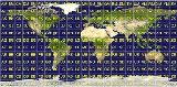
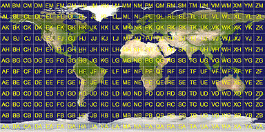
- The first level of Georef divides the world into quadrangles each measuring 15 degrees of longitude by 15 degrees of latitude; this results in 24 zones of longitude and 12 bands of latitude. A longitude zone is identified by a letter from A to Z (omitting I and O) starting at 180 degrees and progressing eastward through the full 360 degrees of longitude; a latitude band is identified by a letter from A through M (omitting I) northward from the south pole. Hence, any 15 degree quadrangle can be identified by two letters; the easting (longitude) is given first, followed by the northing (latitude). These two letters are the first two characters of a full Georef coordinate.
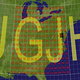
- Each 15-degree quadrangle is further divided into smaller quadrangles, measuring 1 degree of longitude by 1 degree of latitude. These quadrangles are lettered A to Q (omitting I and O), running from west to east for longitude; and A to Q (omitting I and O), running south to north for latitude. These letters form the third and fourth characters of a full Georef coordinate. Four letters thus identify any 1-degree quadrangle in the world.
- Each of the 1-degree quadrangles is further subdivided into 60 1-minute longitude zones, numbered 00 through 59 from west to east, and 60 1-minute latitude bands, numbered 00 to 59 from south to north. These numbers are always written as two digits, with a leading zero if necessary, and the easting is always followed by the northing. Thus, 4 letters and 4 digits give the position of any 1-minute quadrangle.
- Each of the 1-minute quadrangles may be further divided into 10 or 100 smaller divisions both north-south and east-west, permitting the identification of 0.1-minute or 0.01-minute quadrangles. The Georef coordinate for any 0.1-minute quadrangle consists of four letters and six numbers; the Georef coordinate for any 0.01-minute quadrangle consists of four letters and eight numbers.
The initial two letters of a Georef reference, designating the 15 degree quadrangle, can be omitted, if it is clear which 15 degree quadrangle the reference applies to (e.g., when working within a restricted geographical area).
Example
Naval Air Station Patuxent River
"Pax River" redirects here. For the river, see Patuxent River.Naval Air Station Patuxent River , also known as NAS Pax River, is a United States Naval Air Station located in St. Mary's County, Maryland on the Chesapeake Bay near the mouth of the Patuxent River. It is home to the U.S...
is located (to the nearest minute) at position GJPJ3716.
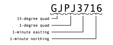
To locate the position from the coordinates, proceed as follows:
- Right from 180° longitude to longitude zone G
- Up from the South Pole to latitude zone J
- Right in zone GJ to the lettered 1° column P
- Up in zone GJ to the lettered 1° row J
- Right in the 1° horizontal zone to 37 minutes
- Up in the 1° vertical zone to 16 minutes
The same co-ordinate shown in 6-digit (1/10 minute) format is GJPJ370160 and in 8-digit (1/100 minute) format is GJPJ37001600.
Designation of area
Extensions to the above notation allow the Georef system to be used to designate an area around a reference point. This is achieved by adding an area designation to a base Georef co-ordinate. The area designation can be the letter S, to specify the sides of a rectangle (separated by the letter X); or the letter R, to specify the radius of a circle. In both cases the units are nautical miles. In addition, the letter H can be added, followed by an altitude in thousands of feet.For example, the reference GJQJ0207S6X8 designates a rectangle centered around Deal Island (GJQJ0207), running 6 nautical miles (11 km) east-west and 8 nautical miles (15 km) north-south. Designation GJPJ4103R5 means a circle around Point Lookout (GJPJ4103) with a radius of 5 nautical miles (9 km). Designation GJPJ3716H17 means a height of 17,000 feet over GJPJ3716.