

Geography of Stockholm
Encyclopedia
Stockholm
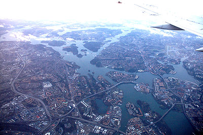
Stockholm is the capital and the largest city of Sweden and constitutes the most populated urban area in Scandinavia. Stockholm is the most populous city in Sweden, with a population of 851,155 in the municipality , 1.37 million in the urban area , and around 2.1 million in the metropolitan area...
is situated on fourteen islands and on the banks to the archipelago where Lake Mälaren
Mälaren
Lake Mälaren is the third-largest lake in Sweden, after Lakes Vänern and Vättern. Its area is 1,140 km² and its greatest depth is 64 m. Mälaren spans 120 kilometers from east to west...
meets the Baltic Sea
Baltic Sea
The Baltic Sea is a brackish mediterranean sea located in Northern Europe, from 53°N to 66°N latitude and from 20°E to 26°E longitude. It is bounded by the Scandinavian Peninsula, the mainland of Europe, and the Danish islands. It drains into the Kattegat by way of the Øresund, the Great Belt and...
. The city centre is virtually situated on the water.
Islands and islets
|
Historical islands and islets:
|
Lakes and watercourses
| Watercourse | Value - (μg/g) |
|---|---|
| Lead - top sediments | |
| Beckholmen Beckholmen Beckholmen is a small island in central Stockholm, Sweden.Having served the city's shipping industry for centuries, Beckholmen is now regarded as a historical monument of national interest, and, by its location just south of Djurgården in the vicinity of other similar localities it also... - Djurgården |
5,700 |
| Riddarfjärden Riddarfjärden Riddarfjärden, literally the Knight Firth, is a bay of Lake Mälaren in central Stockholm. Stockholm was founded in 1252 on an island in the stream where Lake Mälaren drains into the Baltic Sea . The island is today called Stadsholmen and constitutes Stockholm's Old Town... |
940 |
| Liljeholmsviken | 610 |
| Lead - deep sediments | |
| Liljeholmsviken - Reimersholme Reimersholme Reimersholme is a small island in central Stockholm, lying to the west of Södermalm and to the south of the neighbouring island Långholmen. As of 2006 Reimersholme is inhabited by 2,324 people, living in 1,527 dwellings, and with an average annual income of SEK 306,500. 12 percent of the... |
3,400 |
| Bällstaån Bällstaån Bällstaån or Spångaån is a small stream in northern Stockholm. Flowing through the municipalities of Järfälla, Stockholm, Sundbyberg, and Solna, it empties in the bay Bällstaviken, the innermost part of Ulvsundasjön.... - Bällstaviken |
1,900 |
| Riddarfjärden Riddarfjärden Riddarfjärden, literally the Knight Firth, is a bay of Lake Mälaren in central Stockholm. Stockholm was founded in 1252 on an island in the stream where Lake Mälaren drains into the Baltic Sea . The island is today called Stadsholmen and constitutes Stockholm's Old Town... - south of Långholmen Långholmen Långholmen is an island in central Stockholm, between Södermalm and Kungsholmen.Långholmen is a green oasis in the city, and a popular spot for walks, picnics and swimming. The small beaches, located right outside the former prison, are usually crowded in summer. However, up until 1975, Långholmen... |
1,700 |
| Cadmium - top sediments | |
| Brunnsviken - Bergianska trädgården Bergianska trädgården The Bergianska trädgården, the Bergian Garden or Hortus Bergianus, is a botanical garden located in the Frescati area on the outskirts of Stockholm, close to the Swedish Museum of Natural History and the main campus of Stockholm University... |
15 |
| Saltsjön Saltsjön Saltsjön is a bay of the Baltic Sea that extends from Stockholm archipelago to the inner city of Stockholm. Its innermost part reaches the eastern shore of Gamla stan at Skeppsbrokajen. It is navigable for large craft and the major ferry lines to and from Stockholm pass through it... - Beckholmen Beckholmen Beckholmen is a small island in central Stockholm, Sweden.Having served the city's shipping industry for centuries, Beckholmen is now regarded as a historical monument of national interest, and, by its location just south of Djurgården in the vicinity of other similar localities it also... |
10 |
| Brunnsviken - Haga Södra | 8,6 |
| Cadmium - deep sediments | |
| Sicklasjön Sicklasjön Sicklasjön is a lake in eastern central Stockholm, Sweden. It is bordering the municipalities of Stockholm and Nacka and is named for the vicinity to the urban district Sickla.... |
110 |
| Brunnsviken - southern part | 50 |
| Brunnsviken - northern part | 37 |
| Copper - top sediments | |
| Bällstaviken - Ulvsundasjön | 4,590 |
| Saltsjön Saltsjön Saltsjön is a bay of the Baltic Sea that extends from Stockholm archipelago to the inner city of Stockholm. Its innermost part reaches the eastern shore of Gamla stan at Skeppsbrokajen. It is navigable for large craft and the major ferry lines to and from Stockholm pass through it... - south of Djurgården |
1,400 |
| Råcksta träsk Råcksta Träsk Råcksta Träsk is a small lake in the western suburbs of Stockholm, Sweden. Notwithstanding its location in the vicinity of the Swedish capital and high levels of lead and copper, the lake is considered as an important breeding ground for frogs, of moderate interest to pleasure fishing, and of... |
1,200 |
| Copper - deep sediments | |
| Bällstaån Bällstaån Bällstaån or Spångaån is a small stream in northern Stockholm. Flowing through the municipalities of Järfälla, Stockholm, Sundbyberg, and Solna, it empties in the bay Bällstaviken, the innermost part of Ulvsundasjön.... , outlet |
17,000 |
| Lake Mälaren Mälaren Lake Mälaren is the third-largest lake in Sweden, after Lakes Vänern and Vättern. Its area is 1,140 km² and its greatest depth is 64 m. Mälaren spans 120 kilometers from east to west... , north - of Stora Essingen Stora Essingen Stora Essingen is an island and a district in the Kungsholmen borough in Stockholm, Sweden. The Essingeleden motorway, part of European route E4, passes along a section of the eastern shore... |
11,000 |
| Mercury - top sediments | |
| Saltsjön Saltsjön Saltsjön is a bay of the Baltic Sea that extends from Stockholm archipelago to the inner city of Stockholm. Its innermost part reaches the eastern shore of Gamla stan at Skeppsbrokajen. It is navigable for large craft and the major ferry lines to and from Stockholm pass through it... - Beckholmen Beckholmen Beckholmen is a small island in central Stockholm, Sweden.Having served the city's shipping industry for centuries, Beckholmen is now regarded as a historical monument of national interest, and, by its location just south of Djurgården in the vicinity of other similar localities it also... |
38 |
| Liljeholmsviken | 22 |
| Saltsjön Saltsjön Saltsjön is a bay of the Baltic Sea that extends from Stockholm archipelago to the inner city of Stockholm. Its innermost part reaches the eastern shore of Gamla stan at Skeppsbrokajen. It is navigable for large craft and the major ferry lines to and from Stockholm pass through it... - Beckholmssundet |
14 |
| Mercury - deep sediments | |
| Bällstanån - outlet | 100 |
| Liljeholmsviken | 28 |
| Klara sjö Klara Sjö Klara Sjö is a canal in central Stockholm, Sweden.Separating the island Kungsholmen from the northern city district Norrmalm, the canal connects Barnhusviken to Riddarfjärden... |
17 |
The access to fresh water is excellent in Stockholm today, in contrast to the historically horrible state of things, when lakes and watercourses were used as refuse dumps and latrine
Latrine
A latrine is a communal facility containing one or more commonly many toilets which may be simple pit toilets or in the case of the United States Armed Forces any toilet including modern flush toilets...
s, causing epidemic cholera
Cholera
Cholera is an infection of the small intestine that is caused by the bacterium Vibrio cholerae. The main symptoms are profuse watery diarrhea and vomiting. Transmission occurs primarily by drinking or eating water or food that has been contaminated by the diarrhea of an infected person or the feces...
and many other diseases. By the 1860s things changed, as water fetched from Årstaviken, the waters south of Södermalm
Södermalm
Södermalm, often shortened to "Söder", is a district in central Stockholm. It covers the large island formerly called "Åsön". With a population of 99,685, it is one of the most densely populated districts of Scandinavia...
, was treated in the first water-purifying plant
Water purification
Water purification is the process of removing undesirable chemicals, materials, and biological contaminants from contaminated water. The goal is to produce water fit for a specific purpose...
at Skanstull
Skanstull
Skanstull is an area in Södermalm in Stockholm. Skanstull connects the traffic between the inner city and the south parts of Stockholm and its suburbs. Skanstull was originally the city’s southern toll station, but the toll station was removed in 1857....
and from there distributed through water mains.
In modern times the city gets its water from Lake Mälaren
Mälaren
Lake Mälaren is the third-largest lake in Sweden, after Lakes Vänern and Vättern. Its area is 1,140 km² and its greatest depth is 64 m. Mälaren spans 120 kilometers from east to west...
purified by plants at Norsborg
Norsborg
Norsborg is a part of Botkyrka Municipality in Stockholm County, Sweden. Norsborg and Hallunda are continuous suburbs.Norsborg has the south-western terminus of the Stockholm metro system's red line. It was opened in 1975 and is the westernmost of all Stockholm metro stations.The largest fresh...
and Lovön
Lovön
Lovön is an island located in the Swedish Lake Mälaren in Ekerö Municipality of Stockholm County. It was a municipality of its own until 1952, when it was joined with Ekerö Municipality. Lovön's greatest attraction is Drottningholm Palace and its many public gardens, which were built on the island...
, together producing 350,000 m³ per day, which mean Stockholmers are consuming 200 litres per day in average. Water is purified at three plants at Bromma, Henriksdal and Loudden, together filtering some 400,000 m³ sewage per day from pollution, including nitrogen
Nitrogen
Nitrogen is a chemical element that has the symbol N, atomic number of 7 and atomic mass 14.00674 u. Elemental nitrogen is a colorless, odorless, tasteless, and mostly inert diatomic gas at standard conditions, constituting 78.08% by volume of Earth's atmosphere...
and phosphorus
Phosphorus
Phosphorus is the chemical element that has the symbol P and atomic number 15. A multivalent nonmetal of the nitrogen group, phosphorus as a mineral is almost always present in its maximally oxidized state, as inorganic phosphate rocks...
, before discharging it into the Baltic Sea
Baltic Sea
The Baltic Sea is a brackish mediterranean sea located in Northern Europe, from 53°N to 66°N latitude and from 20°E to 26°E longitude. It is bounded by the Scandinavian Peninsula, the mainland of Europe, and the Danish islands. It drains into the Kattegat by way of the Øresund, the Great Belt and...
.
Levels of several pollutants in lakes in the central parts of the city, especially on the western side, are far above average, including substances such as cadmium
Cadmium
Cadmium is a chemical element with the symbol Cd and atomic number 48. This soft, bluish-white metal is chemically similar to the two other stable metals in group 12, zinc and mercury. Similar to zinc, it prefers oxidation state +2 in most of its compounds and similar to mercury it shows a low...
, copper
Copper
Copper is a chemical element with the symbol Cu and atomic number 29. It is a ductile metal with very high thermal and electrical conductivity. Pure copper is soft and malleable; an exposed surface has a reddish-orange tarnish...
, mercury
Mercury (element)
Mercury is a chemical element with the symbol Hg and atomic number 80. It is also known as quicksilver or hydrargyrum...
, and lead
Lead
Lead is a main-group element in the carbon group with the symbol Pb and atomic number 82. Lead is a soft, malleable poor metal. It is also counted as one of the heavy metals. Metallic lead has a bluish-white color after being freshly cut, but it soon tarnishes to a dull grayish color when exposed...
. Decreasing usage of several of these substances have reduced these levels in the upper sediments of the lakes.
The Stockholm area used to contain a lot more lakes and watercourses than it does today, much due to land elevation, but also because of lake reclaims for settlements and health. Historical lakes, such as Fatburssjön on Södermalm
Södermalm
Södermalm, often shortened to "Söder", is a district in central Stockholm. It covers the large island formerly called "Åsön". With a population of 99,685, it is one of the most densely populated districts of Scandinavia...
and Träsket on Norrmalm, were filthy, stinking, and associated with the high mortality in Stockholm until the late 19th century. Other historical lakes, like Packartorgsviken and its interior part Katthavet, were filled with mud and equally stinky. Other lakes still present today were once much larger – such as Magelungen, Drevviken, Judarn
Judarn
Judarn is the name of a small lake in Bromma, a western suburb in Stockholm, Sweden. Surrounded by the forest and nature reserve Judarskogen, it stretches between Åkeshov and Södra Ängby. Three other lakes are found nearby: Kyrksjön, Lillsjön, and Råcksta Träsk...
, and Råstasjön
Råstasjön
Råstasjön is a lake near the Råsunda Stadium in Solna north of Stockholm, Sweden. On the lake, the 1912 final of the Swedish championship in Bandy took place. A promenade of 2.1 km length leads around the lake....
– while some bays of today once were proper lakes – Brunnsviken and Hammarby sjö
Hammarby Sjö
Hammarby Sjö is a watercourse in central Stockholm, Sweden. Separating Stockholm City Centre from South Stockholm, or, more locally, Norra Hammarbyhamnen on eastern Södermalm from Södra Hammarbyhamnen, it connects Saltsjön to Årstasjön.Covering a surface of 34 hectare and having an average depth...
.
Like in many other urban areas, the lakes of Stockholm are directly affected by the city's sewer system and pollution from settlements, traffic, and industry. Sewers often reduces the catchment areas of smaller lakes by redirecting surface water to Lake Mälaren
Mälaren
Lake Mälaren is the third-largest lake in Sweden, after Lakes Vänern and Vättern. Its area is 1,140 km² and its greatest depth is 64 m. Mälaren spans 120 kilometers from east to west...
or Lake Saltsjön
Saltsjön
Saltsjön is a bay of the Baltic Sea that extends from Stockholm archipelago to the inner city of Stockholm. Its innermost part reaches the eastern shore of Gamla stan at Skeppsbrokajen. It is navigable for large craft and the major ferry lines to and from Stockholm pass through it...
. While nutritious substances such as phosphorus
Phosphorus
Phosphorus is the chemical element that has the symbol P and atomic number 15. A multivalent nonmetal of the nitrogen group, phosphorus as a mineral is almost always present in its maximally oxidized state, as inorganic phosphate rocks...
and nitrogen
Nitrogen
Nitrogen is a chemical element that has the symbol N, atomic number of 7 and atomic mass 14.00674 u. Elemental nitrogen is a colorless, odorless, tasteless, and mostly inert diatomic gas at standard conditions, constituting 78.08% by volume of Earth's atmosphere...
are mostly derived from agriculture, urban areas produce high amounts of metal
Metal
A metal , is an element, compound, or alloy that is a good conductor of both electricity and heat. Metals are usually malleable and shiny, that is they reflect most of incident light...
s and organic compound
Organic compound
An organic compound is any member of a large class of gaseous, liquid, or solid chemical compounds whose molecules contain carbon. For historical reasons discussed below, a few types of carbon-containing compounds such as carbides, carbonates, simple oxides of carbon, and cyanides, as well as the...
s. In Stockholm, this mostly applies to central bays – such as Klara sjö
Klara Sjö
Klara Sjö is a canal in central Stockholm, Sweden.Separating the island Kungsholmen from the northern city district Norrmalm, the canal connects Barnhusviken to Riddarfjärden...
, Årstaviken, Ulvsundasjön, Riddarfjärden
Riddarfjärden
Riddarfjärden, literally the Knight Firth, is a bay of Lake Mälaren in central Stockholm. Stockholm was founded in 1252 on an island in the stream where Lake Mälaren drains into the Baltic Sea . The island is today called Stadsholmen and constitutes Stockholm's Old Town...
, and Hammarby Sjö
Hammarby Sjö
Hammarby Sjö is a watercourse in central Stockholm, Sweden. Separating Stockholm City Centre from South Stockholm, or, more locally, Norra Hammarbyhamnen on eastern Södermalm from Södra Hammarbyhamnen, it connects Saltsjön to Årstasjön.Covering a surface of 34 hectare and having an average depth...
- but also waters surrounded by bungalows and villas – like Långsjön
Långsjön
Långsjön is a lake in southern Stockholm, Sweden.The lake is situated in an old residential neighbourhood located between the municipalities of Stockholm and Huddinge and most of the shoreline is private property. Water level is controlled by a sluice in the north-western end of the lake where...
in Älvsjö
Älvsjö
Älvsjö is a district of the city of Stockholm Municipality in Sweden. Located in Söderort and a district in the borough Älvsjö. It has the biggest rentable facility in northern Europe called Stockholm International Fairs. In 2008, total population was 956 inhabitants....
.
Lakes
Watercourses
|
Bays and canals
|
Bridges and viaducts
Gamla stan
Gamla stan , until 1980 officially Staden mellan broarna , is the old town of Stockholm, Sweden. Gamla stan consists primarily of the island Stadsholmen. The surrounding islets Riddarholmen, Helgeandsholmen, and Strömsborg are officially part of, but not colloquially included in, Gamla stan...
was "The city between the bridges" (Staden mellan broarna), a name which is still used for the entire city which spans over numerous islands, islets, and hills. During the course of centuries, the city has seen many bridges relieve each other.
In a urban code dated 1350, King Magnus IV
Magnus IV of Sweden
Magnus Eriksson as Magnus IV was king of Sweden , including Finland, as Magnus VII King of Norway , including Iceland and Greenland, and also ruled Scania . He has also vindictively been called Magnus Smek...
(1316-1377) prescribed the bridges leading over Norrström
Norrström
Norrström in central Stockholm connects Lake Mälaren with the Baltic Sea. It runs from Riddarfjärden, north of Gamla stan, to Saltsjön. Two islands lie within it, Strömsborg and Helgeandsholmen. It is one of two natural waterways between Mälaren and the Baltic sea, the other being Söderström south...
and Söderström to be built and maintained by the city of Stockholm together with six other cities surrounding Lake Mälaren
Mälaren
Lake Mälaren is the third-largest lake in Sweden, after Lakes Vänern and Vättern. Its area is 1,140 km² and its greatest depth is 64 m. Mälaren spans 120 kilometers from east to west...
, as they were the only land passage between the provinces Uppland
Uppland
Uppland is a historical province or landskap on the eastern coast of Sweden, just north of Stockholm, the capital. It borders Södermanland, Västmanland and Gästrikland. It is also bounded by lake Mälaren and the Baltic sea...
and Södermanland
Södermanland
', sometimes referred to under its Latin form Sudermannia or Sudermania, is a historical province or landskap on the south eastern coast of Sweden. It borders Östergötland, Närke, Västmanland and Uppland. It is also bounded by lake Mälaren and the Baltic sea.In Swedish, the province name is...
, north and south of the city respectively. Apparently, in the view of the king, the city, a hundred years after its foundation, still couldn't afford to maintain its own bridges.
Still, these first bridges were in no sense technically complicated or physically impressive, but rather simple wooden bridges, either floating bridge
Pontoon bridge
A pontoon bridge or floating bridge is a bridge that floats on water and in which barge- or boat-like pontoons support the bridge deck and its dynamic loads. While pontoon bridges are usually temporary structures, some are used for long periods of time...
s or beam bridge
Beam bridge
Beam bridges are the most simple of structural forms being supported by an abutment at each end of the deck. No moments are transferred through the support hence their structural type is known as simply supported....
s resting on poles or stone caisson
Caisson (engineering)
In geotechnical engineering, a caisson is a retaining, watertight structure used, for example, to work on the foundations of a bridge pier, for the construction of a concrete dam, or for the repair of ships. These are constructed such that the water can be pumped out, keeping the working...
s, in either case with spans of no more than a few metres. The width probably corresponded to the directions for public roads, eight ell
Ell
An ell , is a unit of measurement, approximating the length of a man's arm.Several national forms existed, with different lengths, includingthe Scottish ell ,the Flemish ell ,the French ell...
or 4,8 metres, which was probably more than enough for many centuries. The long and narrow bridges were easily demolish in case of siege, which besides the drawbridge
Drawbridge
A drawbridge is a type of movable bridge typically associated with the entrance of a castle surrounded by a moat. The term is often used to describe all different types of movable bridges, like bascule bridges and lift bridges.-Castle drawbridges:...
s, also necessary for the passing of ships, was an important defensive strategy. As the accounts of the city tells, spring floods and ice break-ups resulted in the frequent destruction of the bridges.
By the mid 17th century, the population of the city had resulted in settlements north and south of Gamla stan
Gamla stan
Gamla stan , until 1980 officially Staden mellan broarna , is the old town of Stockholm, Sweden. Gamla stan consists primarily of the island Stadsholmen. The surrounding islets Riddarholmen, Helgeandsholmen, and Strömsborg are officially part of, but not colloquially included in, Gamla stan...
, on Norrmalm and Södermalm
Södermalm
Södermalm, often shortened to "Söder", is a district in central Stockholm. It covers the large island formerly called "Åsön". With a population of 99,685, it is one of the most densely populated districts of Scandinavia...
, and the number of bridges had grown considerably, if not their dimensions or quality. In a map dated 1640, three bridges connects Stadsholmen
Stadsholmen
Stadsholmen is the historical name of an island in the centre of Stockholm, Sweden. Together with the small islands Riddarholmen and Helgeandsholmen it forms the Old town of Stockholm....
to Norrmalm passing over Helgeandsholmen
Helgeandsholmen
Helgeandsholmen is a small island in central Stockholm, Sweden. It is located north of Stadsholmen, and east of Strömsborg, with which, together with Riddarholmen, it forms Gamla stan, the old town of Stockholm...
, at the time still a group of islets; while two bridges close to each other lead over to Riddarholmen
Riddarholmen
Riddarholmen is a small islet in central Stockholm, Sweden. The island forms part of Gamla Stan, the old town, and houses a number of private palaces dating from the 17th century...
. Several new bridges of considerable length connected Norrmalm to the islets west and east of it; Blasieholmen, at the time still an islet, was connected to the mainland by a bridge called Näckenströms bro, and northward to present day Strandvägen
Strandvägen
Strandvägen is a boulevard on Östermalm in central Stockholm, Sweden. Completed just in time for the Stockholm World's Fair 1897, it quickly became known as one of the most prestigious addresses in town....
by Stora Ladugårdslandsbron, a 190 metres long bridge on poles; and to the west a bridge connected Norrmalm to Kungsholmen
Kungsholmen
Kungsholmen is an island in Lake Mälaren in Sweden, part of Stockholm City. It is situated north of Riddarfjärden and considered part of the historical province Uppland....
over Blekholmen, a now non-existent islet. By the end of the 17th century, population growth resulted in an additional bridge north of Stadsholmen.
One of the oldest bridges was located where today Stallbron
Stallbron
Stallbron is an arch bridge located in Gamla stan, the old town in central Stockholm, Sweden. Stretching some 20 meters over Stallkanalen it connects Riksgatan passing through the Parliament Building on Helgeandsholmen to the square Mynttorget on Stadsholmen from where Västerlånggatan extends it...
is found, immediately south of the Parliament Building
Parliament of Sweden
The Riksdag is the national legislative assembly of Sweden. The riksdag is a unicameral assembly with 349 members , who are elected on a proportional basis to serve fixed terms of four years...
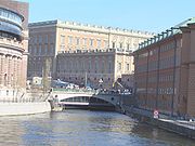
. The first stone bridge, Norrbro
Norrbro
Norrbro is an arch bridge over Norrström in central Stockholm. It extends north from the northern front of the Stockholm Palace passing over Helgeandsholmen in front of the parliament building, Riksdagen, and from there over to Gustaf Adolfs torg...
, was built in front of the Royal Palace
Stockholm Palace
The Stockholm Palace is the official residence and major royal palace of the Swedish monarch. . Stockholm Palace is located on Stadsholmen , in Gamla Stan in the capital, Stockholm...
under Gustav III
Gustav III of Sweden
Gustav III was King of Sweden from 1771 until his death. He was the eldest son of King Adolph Frederick and Queen Louise Ulrica of Sweden, she a sister of Frederick the Great of Prussia....
.
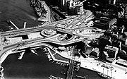
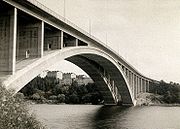
Not until the 20th century, Stockholm was able to surpass the straits and bays surrounding the city. Half of the about 30 bridges in central Stockholm were built 1920–50, most of them during the 1930s. This development was due to increasing traffic loads caused by a fivefold increase of vehicles in the 1920s. At Slussen
Slussen
Slussen is an area of central Stockholm, connecting Södermalm and Gamla stan. The area is named after the locks between Lake Mälaren and the Baltic Sea. The locks themselves allow passage between these two bodies of water...
, passing ships caused stationary rows of trams several hundreds metres long. The situation was solved when a traffic committee in 1930 could present the so-called "clover-leaf solution" of engineer Gösta Lundborg and architect Tage William-Olsson
Tage William-Olsson
Tage William-Olsson , Swedish architect and Chief town planning architect of Gothenburg. William-Olsson was the creator of the important infrastructure-project, the traffic-roundabout Slussen in Stockholm....
inaugurated in 1935. The modernity of the solution put Stockholm in a state of rapture and impressed even Le Corbusier
Le Corbusier
Charles-Édouard Jeanneret, better known as Le Corbusier , was a Swiss-born French architect, designer, urbanist, writer and painter, famous for being one of the pioneers of what now is called modern architecture. He was born in Switzerland and became a French citizen in 1930...
, who praised the scale of the construction and invited the world to follow the example of Stockholm.
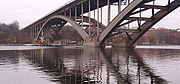
Meanwhile, across the Riddarfjärden
Riddarfjärden
Riddarfjärden, literally the Knight Firth, is a bay of Lake Mälaren in central Stockholm. Stockholm was founded in 1252 on an island in the stream where Lake Mälaren drains into the Baltic Sea . The island is today called Stadsholmen and constitutes Stockholm's Old Town...
bay, construction works had started on Västerbron
Västerbron
Västerbron is an arch bridge in central Stockholm, Sweden. With a total length exceeding 600 m, 340 m of which stretches over water, it is one of the major bridges in Stockholm, offering one of the most panoramic views of the central part of the city centering on Gamla stan, the old town...
, the large bridge offering a north-south passage west of the historical city centre. Designed by architects David Dahl and Paul Hedqvist
Paul Hedqvist
Paul Hedqvist was a Swedish modernist architect with many official commissions in Sweden through the 1930s, including housing projects, major bridges, many schools, and urban planning work. His practice evolved into designing office towers and at least one major stadium in the postwar 1950s...
and engineered by Ernst Nilsson
Ernst Nilsson
Ernst Hilding Waldemar Nilsson was a Swedish wrestler who competed in the 1912 Summer Olympics, in the 1920 Summer Olympics, and in the 1924 Summer Olympics....
and Salomon Kasarnowski, Västerbron became the first large bridge designed by this quartet. Tranebergsbron
Tranebergsbron
Tranebergsbron is a double arch bridge in central Stockholm, Sweden. Stretching over the strait Tranebergssund it connects the major island Kungsholmen to the western suburb Bromma...
was inaugurated in 1934, with its span of 200 m, for a few years the world's longest span. These large-scale bridges not only tied various parts of the city together, but their mere size changed the cityscape permanently. Considerably smaller but during the decade equally praised was the small Riksbron
Riksbron
Riksbron is an arch bridge in central Stockholm, Sweden leading from Drottninggatan on Norrmalm 44 metres over to Riksgatan on Helgeandsholmen....
designed by Ragnar Östberg
Ragnar Östberg
Ragnar Östberg was a Swedish architect who is most famous for designing Stockholm City Hall. He is the most famous architect within the so-called "national romanticist" movement in Sweden...
.
National parks and nature reserves
The nature reserveNature reserve
A nature reserve is a protected area of importance for wildlife, flora, fauna or features of geological or other special interest, which is reserved and managed for conservation and to provide special opportunities for study or research...
s in Stockholm involves regulations affecting both landowners and the general public by regulating usage of insecticide
Insecticide
An insecticide is a pesticide used against insects. They include ovicides and larvicides used against the eggs and larvae of insects respectively. Insecticides are used in agriculture, medicine, industry and the household. The use of insecticides is believed to be one of the major factors behind...
s and fertilizer
Fertilizer
Fertilizer is any organic or inorganic material of natural or synthetic origin that is added to a soil to supply one or more plant nutrients essential to the growth of plants. A recent assessment found that about 40 to 60% of crop yields are attributable to commercial fertilizer use...
s, construction of bridges, lighting of fires, camping, anchoring, and keeping unleashed dogs. A plan for the care and development of a nature reserve often means the city as well as private landowners are obliged to guarantee the maintenance of the area.
There is one national urban park, Kungliga Nationalstadsparken, and three major nature reserves in Stockholm, Kyrksjölöten, Judarskogen and Grimstaskogen while Hansta is likely to become one soon. Transforming the other areas listed below into nature reserves is being investigated, as they all are regarded to be of great recreational and biological value.
- Judarskogen
- Kyrksjölöten
- Hansta
- Järvafältet
- Kyrkhamn-Lövsta
- Grimstaskogen (Grimsta Nature Reserve)
- Sätraskogen
- Årstaskogen and Årsta holmar
- Älvsjöskogen
- FlatenFlatenFlaten is a lake in southern Stockholm, Sweden, located just north of Lake Drevviken. The name is also used for the surrounding area and the nature reserve created there in 2007....
- Hammarbyskogen and Nacka Open-Air Area
- Fagersjöskogen and Farstanäset
- Rågsved Open-Air Area
Places
- RiddarfjärdenRiddarfjärdenRiddarfjärden, literally the Knight Firth, is a bay of Lake Mälaren in central Stockholm. Stockholm was founded in 1252 on an island in the stream where Lake Mälaren drains into the Baltic Sea . The island is today called Stadsholmen and constitutes Stockholm's Old Town...
, RiddarholmskyrkanRiddarholmskyrkanThe Riddarholmen Church is the burial church of the Swedish monarchs. It is located on the island of Riddarholmen, close to the Royal Palace in Stockholm, Sweden. The congregation was dissolved in 1807 and today the church is used only for burial and commemorative purposes. Swedish monarchs from... - Stockholms strömStockholms strömStockholms ström, also known as Strömmen, in Stockholm is the innermost part of Saltsjön, a bay of the Baltic Sea. It continues into Lake Mälaren through Norrström.-See also:*Geography of Stockholm*Rivers of Sweden...
- Gamla StanGamla stanGamla stan , until 1980 officially Staden mellan broarna , is the old town of Stockholm, Sweden. Gamla stan consists primarily of the island Stadsholmen. The surrounding islets Riddarholmen, Helgeandsholmen, and Strömsborg are officially part of, but not colloquially included in, Gamla stan...
- NorrmalmstorgNorrmalmstorgNorrmalmstorg is a square in central Stockholm. The square connects shopping streets Hamngatan and Biblioteksgatan and is the starting point for tram travellers with the Djurgården line...
- Sergels TorgSergels TorgSergels torg is the most central public square in Stockholm, Sweden, named after 18th century sculptor Johan Tobias Sergel, whose workshop was once located north of the square.- Overview :...
- Djurgården, Gröna LundGröna LundTivoli Gröna Lund or Grönan is an amusement park in Stockholm, Sweden. It is located on the seaward side of the Djurgården island and is relatively small compared to other amusement parks, mainly due to its central location, which limits expansion. Gröna Lund is a popular venue for concerts during...
- Norrmalm
- Östermalm
- SödermalmSödermalmSödermalm, often shortened to "Söder", is a district in central Stockholm. It covers the large island formerly called "Åsön". With a population of 99,685, it is one of the most densely populated districts of Scandinavia...
- SlussenSlussenSlussen is an area of central Stockholm, connecting Södermalm and Gamla stan. The area is named after the locks between Lake Mälaren and the Baltic Sea. The locks themselves allow passage between these two bodies of water...
- RiddarholmskyrkanRiddarholmskyrkanThe Riddarholmen Church is the burial church of the Swedish monarchs. It is located on the island of Riddarholmen, close to the Royal Palace in Stockholm, Sweden. The congregation was dissolved in 1807 and today the church is used only for burial and commemorative purposes. Swedish monarchs from...
- Sager HouseSager HouseThe Sager House or Sager Palace is the official residence of the Prime Minister of Sweden at Strömgatan 18 in Sweden's capital Stockholm.- Location and Environment :...
, RosenbadRosenbadRosenbad is a building in central Stockholm, precinct of Norrmalm, designed by Art Nouveau architect Ferdinand Boberg and completed in 1902. It is located on Strömgatan on the North side of the river Norrström... - Stockholm City HallStockholm City HallStockholm City Hall is the building of the Municipal Council for the City of Stockholm in Sweden. It stands on the eastern tip of Kungsholmen island, next to Riddarfjärden's northern shore and facing the islands of Riddarholmen and Södermalm. It houses offices and conference rooms as well as...
- Royal Palace in Stockholm
Divisions
The city is divided into 18 boroughs as regulated by the City Council. In looser terms, the city is also divided into three major parts:- Stockholm City CentreStockholm City CentreStockholm City Centre is the city centre of Stockholm in Sweden. The entire city of Stockholm is also the centre of the Stockholm Metropolitan Area....
(Innerstaden) - South StockholmSouth StockholmSöderort is the southern suburban part of Stockholm Municipality, Sweden...
(Söderort) - West StockholmWest StockholmVästerort is the western part of Stockholm Municipality in Stockholm County, Sweden. It also forms part of Stockholm urban area and of Stockholm Metropolitan Area...
(Västerort)
Surrounding the city is the Stockholm Metropolitan Area.
See also
- Stockholm MetroStockholm MetroThe Stockholm Metro is a metro system in Stockholm, Sweden. The first line opened in 1950, and today the system has 100 stations in use, of which 47 are underground and 53 above ground. There are seven lines numbered from 10 to 19, in three groups identified by a color: the Green, Red and Blue lines...
- Stockholm ArchipelagoStockholm archipelagoThe Stockholm archipelago is the largest archipelago of Sweden, and one of the largest archipelagos of the Baltic Sea.-Geography:The archipelago extends from Stockholm roughly 60 kilometers to the east...
- List of islands of Sweden