.gif)
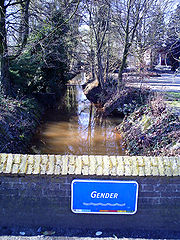
Gender (creek)
Encyclopedia
Stream
A stream is a body of water with a current, confined within a bed and stream banks. Depending on its locale or certain characteristics, a stream may be referred to as a branch, brook, beck, burn, creek, "crick", gill , kill, lick, rill, river, syke, bayou, rivulet, streamage, wash, run or...
in the Dutch
Netherlands
The Netherlands is a constituent country of the Kingdom of the Netherlands, located mainly in North-West Europe and with several islands in the Caribbean. Mainland Netherlands borders the North Sea to the north and west, Belgium to the south, and Germany to the east, and shares maritime borders...
province
Province
A province is a territorial unit, almost always an administrative division, within a country or state.-Etymology:The English word "province" is attested since about 1330 and derives from the 13th-century Old French "province," which itself comes from the Latin word "provincia," which referred to...
of Noord-Brabant. It originates in originally marsh
Marsh
In geography, a marsh, or morass, is a type of wetland that is subject to frequent or continuous flood. Typically the water is shallow and features grasses, rushes, reeds, typhas, sedges, other herbaceous plants, and moss....
y flatlands near Steensel
Steensel
Steensel is a village on the Gender stream in the municipality of Eersel, North Brabant, the Netherlands. Steensel is part of the Acht Zaligheden , along with Eersel, Knegsel, Duizel, Wintelre, Netersel, Hulsel en Reusel...
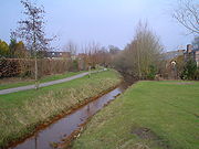
and flows through Veldhoven
Veldhoven
Veldhoven is a municipality and a town on the Gender stream in the southern Netherlands, located just south-west of Eindhoven.- Population centres :...
and its eastern district Meerveldhoven in a general east-northeast direction towards Eindhoven.
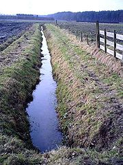
The Gender is one of many small stream
Stream
A stream is a body of water with a current, confined within a bed and stream banks. Depending on its locale or certain characteristics, a stream may be referred to as a branch, brook, beck, burn, creek, "crick", gill , kill, lick, rill, river, syke, bayou, rivulet, streamage, wash, run or...
s that drain what once was the marshy heath
Heath (habitat)
A heath or heathland is a dwarf-shrub habitat found on mainly low quality acidic soils, characterised by open, low growing woody vegetation, often dominated by plants of the Ericaceae. There are some clear differences between heath and moorland...
and moorland
Moorland
Moorland or moor is a type of habitat, in the temperate grasslands, savannas, and shrublands biome, found in upland areas, characterised by low-growing vegetation on acidic soils and heavy fog...
of eastern Noord-Brabant and the Kempen plateau
Plateau
In geology and earth science, a plateau , also called a high plain or tableland, is an area of highland, usually consisting of relatively flat terrain. A highly eroded plateau is called a dissected plateau...
. Similar streams include the Dommel
Dommel
The Dommel is a creek in Belgium and the Netherlands, left tributary of the Dieze. It rises in north-eastern Belgium near Peer and flows into the southern part of the Netherlands. The Dommel takes in water from the Keersop, Tongelreep, Run, Gender and Kleine Dommel streams and merges at...
, Kleine Dommel, Keersop, Tongelreep, Aa
Aa River (Meuse)
The Aa is a small river in The Netherlands. It rises near Meijel in the southeastern province of Limburg, in the Peel region. It flows northwest through the province of North Brabant towards 's-Hertogenbosch, roughly along the Zuid-Willemsvaart canal. In 's-Hertogenbosch, at the confluence of the...
, Binnen-Dieze and Run
Run (stream)
The Run is a stream in the Dutch province of Noord-Brabant. It is a left tributary of the Dommel and part of the Meuse River basin.The Run originates near the town of Weebosch and flows in a general northeast direction towards Veldhoven....
. All of these streams at one point or other merge to finally form River Dieze
Dieze
The Dieze is a short river in North Brabant, The Netherlands, tributary of the Meuse. It is formed by the confluence of the rivers Aa and Dommel in 's-Hertogenbosch. The part of the Dieze in the centre of 's-Hertogenbosch is called "Binnendieze": a partly covered network of canals...
in Den Bosch, which in turn flows into River Maas.
Near Eindhoven, the Gender originally flowed just north of the medieval city walls to end in confluence with the Dommel
Dommel
The Dommel is a creek in Belgium and the Netherlands, left tributary of the Dieze. It rises in north-eastern Belgium near Peer and flows into the southern part of the Netherlands. The Dommel takes in water from the Keersop, Tongelreep, Run, Gender and Kleine Dommel streams and merges at...
stream, but during the Middle Ages
Middle Ages
The Middle Ages is a periodization of European history from the 5th century to the 15th century. The Middle Ages follows the fall of the Western Roman Empire in 476 and precedes the Early Modern Era. It is the middle period of a three-period division of Western history: Classic, Medieval and Modern...
its course was diverted southward through the city centre, to provide the city with freshwater supplies and fire-extinguishing means. By the nineteenth century, the stretch within the old city had been filled in and the Gender now ended in De Vest, the city moat
Moat
A moat is a deep, broad ditch, either dry or filled with water, that surrounds a castle, other building or town, historically to provide it with a preliminary line of defence. In some places moats evolved into more extensive water defences, including natural or artificial lakes, dams and sluices...
(which itself was connected to the Dommel).
Drainage basin
A drainage basin is an extent or an area of land where surface water from rain and melting snow or ice converges to a single point, usually the exit of the basin, where the waters join another waterbody, such as a river, lake, reservoir, estuary, wetland, sea, or ocean...
have seen the last stretch before the city centre cut off. In order to regulate water levels of the Dommel and Gender streams, which occasionally threatened to flood Eindhoven's inner city area, a regulation canal (Afwateringskanaal) was dug in the late 1930s
1930s
File:1930s decade montage.png|From left, clockwise: Dorothea Lange's photo of the homeless Florence Thompson show the effects of the Great Depression; Due to the economic collapse, the farms become dry and the Dust Bowl spreads through America; The Battle of Wuhan during the Second Sino-Japanese...
to connect the Dommel to the newly-constructed Beatrix Canal
Beatrix Canal
The Beatrix Canal is a 8.4 km long canal in the Dutch province of North Brabant. It was constructed to provide the city of Eindhoven with access to the Wilhelmina Canal....
. Into this regulation canal the Gender now discharges. A further downstream section of the Gender between the regulation canal and the Engelsbergen pond remains, but receives little to no water of the original stream. Two districts of Eindhoven that are situated on its banks were named after the Gender stream: Genderdal ('Gender Dale') and Genderbeemd ('Gender Meadows').