
Geelong Bypass
Encyclopedia
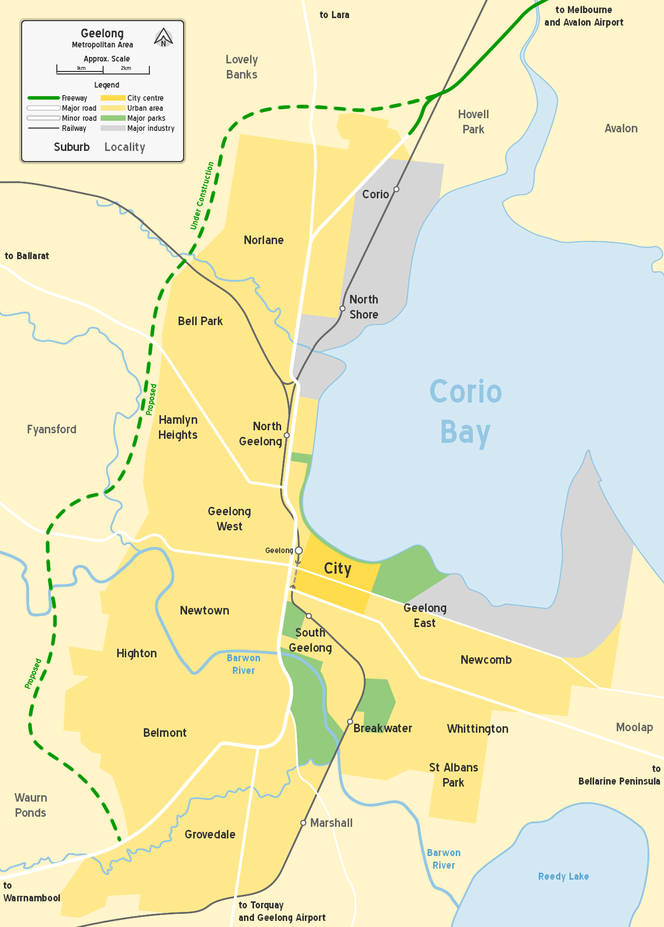
The Geelong Ring Road is a freeway ring road in Australia that extends for 25 km (15.5 mi) beside Geelong's western suburbs from the Princes Freeway
at Corio
to the Princes Highway
at Waurn Ponds
. It also connects to the Midland Highway towards Ballarat
, and the Hamilton Highway
. Sections one and two were officially opened 14 December 2008, with section three on 14 June 2009. Section four is currently under construction to avoid traffic lights at the southern end of the road.
In 1972 saw a number of proposals made, one for a freeway though Geelong West, and another for Aberdeen Street to be upgraded into a major road with the acquisition of 99 houses. Both of these proposals were dropped after residents objections. 1979 saw a Melbourne firm carry out acoustic testing at Wandana Heights to test the impact of a freeway. The alignment was finalised in 1979 and appeared as a proposed freeway in the Melway
street directory for a number of years.
Growing traffic led to Latrobe Terrace being upgraded into a major highway in early 1989, along with the construction of the James Harrison Bridge.
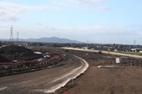
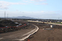
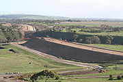
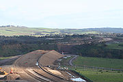
Construction on the Geelong Ring Road began in early 2006 with the freeway section to Waurn Ponds scheduled for completion in 2009. A total of $384 million from the Victorian and Federal Governments was committed initially to fund the first three sections of the project.
The Geelong Ring Road (freeway type) is to be constructed in three sections as follows; with all three under construction:
There was much local debate on the proposed route for Section 3. The final decision was made on 7 July 2006, while construction commenced in September 2007. There will be no toll when the Geelong Ring Road opens to traffic.
In October 2007, during the 2007 Federal election campaign the Labor party promised $107.5 million for the fourth stage of the road. It was made up of $45 million for stage 4B, on top of their promise made in September for $62.5 million towards Stage 4A. In May 2008 stages 4A and 4B were given the go ahead, with State Premier John Brumby announcing $65 million in funding for stage 4B, in addition to earlier State Government funding of $63 million for stage 4A. Running from the Princes Highway at Waurn Ponds
; it will run from Anglesea Road near Hams Road, through the Blue Circle Quarry to the Princes Highway, near Draytons Road.
On 17 December 2008 a $62 million contract was awarded to Fulton Hogan to design and build section 4A of the ring road to Anglesea Road.
The State and Federal Governments have also each committed $110 million to duplicate the Princes Highway to Winchelsea
. An extra stage connecting the road to the Surf Coast Highway is also being investigated, but the Government has not put a timeframe on when a final decision will be made.
A shared bicycle and pedestrian pathway will be also be built along the freeway from Broderick Road, Corio to Church Street, Hamlyn Heights. Built at a cost of $4 million, the trail will not connect into the Geelong bicycle network, due to a short missing link between Church Street and the Fyansford Common.
 Sections 1 and 2
The design and construction contract for the 10.5 km long section 1 was awarded to Abigroup Contractors in November 2005 for $134.8 million. Construction work commenced on 17 February 2006.
Section 2 was delivered via two separate design and construction contracts. The contract for 4.5 km of freeway was awarded to Cut and Fill Pty Ltd for $31.7 million, while FRH (now Fulton Hogan) won the $15.5 million contract for the Moorabool River bridges. Construction work on section two commenced on 27 September 2006.
The Creamery Road overpass in Bell Post Hill was the first major element of the project to be opened in January 2007 (a number of minor access road deviations had been completed earlier). The Broderick Road overpass was opened in November 2007. The 200m long bridges over the Moorabool River
, the largest on the project, had the final span installed on 6 March 2008. The bridges contain 70 beams and have 12 piers.
In 2007 VicRoads said that section one was to be completed by February 2008, but by that time completion had been pushed out to the middle of 2008. By this time earth works were completed on stage two, with 700,000 cubic metres of earth moved, and installation of noise walls had started along with landscaping.
By May 2008 completion of stages one and two of the road has been delayed until November, with VicRoads staying that "wet and cold weather in recent weeks had prevented sealing the road surface". At this time the Victorian Government permitted the filming of a plane crash scene from the Nicolas Cage
film Knowing
on the incomplete road at Corio
.
Local police expressed concerns about a staged opening of the road, with drivers using temporary shortcuts not suited to heavy traffic and large vehicles.
Construction on sections 1 and 2 reached practical completion when the road opened to traffic on 14 December 2008.
Section 3
The $108.3 million design and construction contract for section 3 was awarded on 25 July 2007 to Abigroup Contractors. Section three works include 7.5 kilometres of freeway, the transportation of 4.7 million cubic metres of earth, and twin 110 metre long bridges over the Barwon River
. Construction of section 3 commenced on 14 September 2007.
By February 2008 550,000 cubic metres of earth had been moved to the north and south of Barrabool Road, and the foundation works for the arch structure over Wandana Drive were complete. Section three was originally scheduled for completion in the second half of 2009 however it was announced in early June 2009 that section three would open 6 months early on 14 June 2009.
Section 4A
The design and construction contract for section 4A was awarded to Fulton Hogan on 16 December 2008 for $61.7 million. Construction began in March 2009 and is expected to be completed by the end of 2010.
, who announced the naming of the feature bridge on stage two of the road as the "Lewis Bandt Bridge
", in honour of the Ford Australia
engineer who is credited as the inventor of the Utility vehicle
, in Geelong.
Section 3 opened on 14 June 2009.
The completion of the Geelong Ring Road is expected to bring large economic benefits to the region. Approximately 582 hectares of land west of the road has been identified for use as new industrial land, however resistance from nearby residents in the Lovely Banks
area to two proposed service station developments has cast some cloud over future development.
region".
More likely however is that the overall difference would not be significant, as traffic that would previously have travelled through the centre of Geelong via the main Melbourne Road/Latrobe Terrace/James Harrison Bridge/Settlement Road/High Street/Princes Highway
West corridor, would now travel via the Geelong Ring Road, improving the environmental condition for the majority of Geelong residents, by removing that traffic from the most heavily populated areas of the city. There has been no environmental study that shows that the construction of the Geelong Ring Road would adversely affect the environment.
The loss of amenity experienced by residents in the immediate vicinity of the freeway corridor due to the severing of a number of local roads was also a source of criticism, but most of these roads have been reconnected via upgraded existing roads, or the addition of new roads.
The main opposition to this project had nothing to do with environmental issues. In 1991 VicRoads undertook its own study and decided to abandon plans to utilise the Section 3 route in favour of a bypass from Avalon Road across Corio Bay to Point Henry and then along the Barwon River valley to the Surf Coast Highway, Anglesea Road and Princes Highway West.
As a result of VicRoads decision the freeway reservation south of Princes Highway West to the Anglesea Road was abandoned and was developed as residential allotments with the approval of VicRoads and South Barwon Council.
Over the next 11 years many people built houses along the route especially from Wandana Drive to the Princes Highway West. Then in 2001 the Victorian Government initiated a project to investigate options for a Geelong Bypass. It involved a steering committee, technical committee and Community consultation committee. After 18 months the expectations based on information provided to participants was that the VicRoads preferred route would be recommended. To the surprise of almost all Westconnect - the route to the west of Geelong including the abandoned Section 3 was recommended. Much later it was found that someone had re-costed the eastern route as a full 2 lanes each way freeway construction - even though such a construction was not warranted - and that re-costing made the eastern route uneconomic.
Immediately opposition was generated by those who had built close to the Ring Road reservation. VicRoads proposes 4 alternate routes with the result that further opposition was generated from people located close to Options 2 and 3.
In May 2005 during negotiations between Planning Panels Victoria and VicRoads over an environmental Effects process, Planning Panels requested VicRoads minimise the Options to be considered. VicRoads obliged by reducing the Options to 1 and 2, even though Option 3 was the best Option. As a result during the EES process a huge amount of pressure was put on the Planning Panel in respect of consideration of Option 3 but they only agreed to consider it if neither 1 or 2 satisfied the criteria being considered.
In its recommendation, in spite of neither Option 1 or 2 satisfying the criteria. Planning Panels recommended Option 1 plus an urgent need to consider further work to overcome the problems with Option 1 including the fact it ended in the middle of a commercial area with nowhere to go to connect to Anglesea Road et cetera.
As a result the estimated cost of the route to Anglesea Road and then around to Princes Highway West is $618 nillion - about $200 nillion more than Option 3 plus a connection to Anglesea Road would have cost. In addition the fact that the route is 3 km longer than Option 1, that most freight traffic comes from the west, and the route requires trucks to negotiate slopes down into the Waurn Ponds Valley and then back out again means the additional cost to users is around $10 million per annum. Finally around 360 households are located within 160 metres of the Ring Road and subject to noise and diesel engine particulate matter pollution whereas with the Option 3 route only 10 houses would have been within 160 metres.
Princes Freeway
The Princes Freeway is a , 2 section freeway, which links Melbourne to Geelong on the west and Morwell on the east . It continues beyond these extremities as the Princes Highway towards Adelaide to the west and Sydney to the east...
at Corio
Corio, Victoria
Corio is a residential, industrial and one of the largest suburbs of Geelong, Victoria, Australia, located approximately 9 km north of the Geelong central business district...
to the Princes Highway
Princes Highway
The Princes Highway extends from Sydney to Port Augusta via the coast through the states of New South Wales, Victoria and South Australia, a distance of 1941 km or 1898 km via the former alignments of the highway ....
at Waurn Ponds
Waurn Ponds, Victoria
Waurn Ponds is a mainly residential southern suburb of Geelong, Victoria, Australia.The suburb is bounded by Rossack Drive, Princes Highway, the Geelong to Warnambool railway, Reservoir Road, Draytons Road, Pigdons Road, Deakin University and Honeys Road....
. It also connects to the Midland Highway towards Ballarat
Ballarat, Victoria
Ballarat is a city in the state of Victoria, Australia, approximately west-north-west of the state capital Melbourne situated on the lower plains of the Great Dividing Range and the Yarrowee River catchment. It is the largest inland centre and third most populous city in the state and the fifth...
, and the Hamilton Highway
Hamilton Highway
The Hamilton Highway in western Victoria, Australia runs from the Princes Highway in Geelong west to the town of Hamilton through the towns of Inverleigh, Cressy, Lismore, Derrinallum, Darlington, Mortlake, and Penshurst....
. Sections one and two were officially opened 14 December 2008, with section three on 14 June 2009. Section four is currently under construction to avoid traffic lights at the southern end of the road.
History
One of the first plans for a ring road of Geelong dates back to 7 March 1969, when a report was released by the Geelong Regional Commission. It said that the ring road could be delayed for up to 15 years.In 1972 saw a number of proposals made, one for a freeway though Geelong West, and another for Aberdeen Street to be upgraded into a major road with the acquisition of 99 houses. Both of these proposals were dropped after residents objections. 1979 saw a Melbourne firm carry out acoustic testing at Wandana Heights to test the impact of a freeway. The alignment was finalised in 1979 and appeared as a proposed freeway in the Melway
Melway
Melway is an almost ubiquitous street directory for Melbourne, Australia and its immediate surrounds, including the city of Geelong. It is currently in its 39th edition—the 2012 edition—which was released in July 2011.-History:Melway was conceived by Merv Godfrey and Iven Mackay in the 1950s...
street directory for a number of years.
Growing traffic led to Latrobe Terrace being upgraded into a major highway in early 1989, along with the construction of the James Harrison Bridge.
Sections
The project was renamed the Geelong Ring Road on 20 February 2007.Construction on the Geelong Ring Road began in early 2006 with the freeway section to Waurn Ponds scheduled for completion in 2009. A total of $384 million from the Victorian and Federal Governments was committed initially to fund the first three sections of the project.
The Geelong Ring Road (freeway type) is to be constructed in three sections as follows; with all three under construction:
- Section 1: Princes Freeway, CorioCorio, VictoriaCorio is a residential, industrial and one of the largest suburbs of Geelong, Victoria, Australia, located approximately 9 km north of the Geelong central business district...
to Midland Highway, Bell Post HillBell Post Hill, VictoriaBell Post Hill is a residential suburb of Geelong, Victoria, Australia. The origin of the suburb's name is thought to be from a lookout or warning bell on a post situated on the hill overlooking Corio Bay... - Section 2: Midland Highway, Hamlyn HeightsHamlyn Heights, VictoriaHamlyn Heights is a residential suburb of Geelong, Victoria, Australia. It located to the west of the city on hills that overlook Corio Bay.The suburb boundaries are Church St, Ballarat Rd, Moorabool River and two unmarked boundaries extending between Church St to Moorabool River and between...
to Hamilton Highway, FyansfordFyansford, VictoriaFyansford is a township on the western edge of Geelong, Victoria, Australia, named after Captain Foster Fyans who came to Geelong as a Police magistrate in October, 1837. It is located at the junction of the Barwon and Moorabool rivers.... - Section 3: Hamilton Highway, FyansfordFyansford, VictoriaFyansford is a township on the western edge of Geelong, Victoria, Australia, named after Captain Foster Fyans who came to Geelong as a Police magistrate in October, 1837. It is located at the junction of the Barwon and Moorabool rivers....
to Princes Highway, Waurn PondsWaurn Ponds, VictoriaWaurn Ponds is a mainly residential southern suburb of Geelong, Victoria, Australia.The suburb is bounded by Rossack Drive, Princes Highway, the Geelong to Warnambool railway, Reservoir Road, Draytons Road, Pigdons Road, Deakin University and Honeys Road....
There was much local debate on the proposed route for Section 3. The final decision was made on 7 July 2006, while construction commenced in September 2007. There will be no toll when the Geelong Ring Road opens to traffic.
- Section 4: split into three sub-sections; with planning underway:
- Stage 4A (Connection from Geelong Ring Road to Anglesea Road)
- Stage 4B (Connection from Anglesea Road - Princes Highway West)
- Stage 4C (Surf Coast Highway connection)
In October 2007, during the 2007 Federal election campaign the Labor party promised $107.5 million for the fourth stage of the road. It was made up of $45 million for stage 4B, on top of their promise made in September for $62.5 million towards Stage 4A. In May 2008 stages 4A and 4B were given the go ahead, with State Premier John Brumby announcing $65 million in funding for stage 4B, in addition to earlier State Government funding of $63 million for stage 4A. Running from the Princes Highway at Waurn Ponds
Waurn Ponds, Victoria
Waurn Ponds is a mainly residential southern suburb of Geelong, Victoria, Australia.The suburb is bounded by Rossack Drive, Princes Highway, the Geelong to Warnambool railway, Reservoir Road, Draytons Road, Pigdons Road, Deakin University and Honeys Road....
; it will run from Anglesea Road near Hams Road, through the Blue Circle Quarry to the Princes Highway, near Draytons Road.
On 17 December 2008 a $62 million contract was awarded to Fulton Hogan to design and build section 4A of the ring road to Anglesea Road.
The State and Federal Governments have also each committed $110 million to duplicate the Princes Highway to Winchelsea
Winchelsea, Victoria
Winchelsea is a town in Victoria, Australia. It is in the Surf Coast Shire local government area and located on the Barwon River 115 km south-west of Melbourne and close to Geelong .- History :...
. An extra stage connecting the road to the Surf Coast Highway is also being investigated, but the Government has not put a timeframe on when a final decision will be made.
A shared bicycle and pedestrian pathway will be also be built along the freeway from Broderick Road, Corio to Church Street, Hamlyn Heights. Built at a cost of $4 million, the trail will not connect into the Geelong bicycle network, due to a short missing link between Church Street and the Fyansford Common.
Construction
The design and construction contract for the 10.5 km long section 1 was awarded to Abigroup Contractors in November 2005 for $134.8 million. Construction work commenced on 17 February 2006.
Section 2 was delivered via two separate design and construction contracts. The contract for 4.5 km of freeway was awarded to Cut and Fill Pty Ltd for $31.7 million, while FRH (now Fulton Hogan) won the $15.5 million contract for the Moorabool River bridges. Construction work on section two commenced on 27 September 2006.
The Creamery Road overpass in Bell Post Hill was the first major element of the project to be opened in January 2007 (a number of minor access road deviations had been completed earlier). The Broderick Road overpass was opened in November 2007. The 200m long bridges over the Moorabool River
Moorabool River
The Moorabool River is a river in Victoria, Australia that runs past several small towns and areas such as Meredith, Anakie, and Staughton Vale...
, the largest on the project, had the final span installed on 6 March 2008. The bridges contain 70 beams and have 12 piers.
In 2007 VicRoads said that section one was to be completed by February 2008, but by that time completion had been pushed out to the middle of 2008. By this time earth works were completed on stage two, with 700,000 cubic metres of earth moved, and installation of noise walls had started along with landscaping.
By May 2008 completion of stages one and two of the road has been delayed until November, with VicRoads staying that "wet and cold weather in recent weeks had prevented sealing the road surface". At this time the Victorian Government permitted the filming of a plane crash scene from the Nicolas Cage
Nicolas Cage
Nicolas Cage is an American actor, producer and director, having appeared in over 60 films including Raising Arizona , The Rock , Face/Off , Gone in 60 Seconds , Adaptation , National Treasure , Ghost Rider , Bad Lieutenant: Port of Call New Orleans , and...
film Knowing
Knowing (film)
Knowing is a 2009 American-British science fiction film directed by Alex Proyas and starring Nicolas Cage. The project was originally attached to a number of directors under Columbia Pictures, but it was placed in turnaround and eventually picked up by Escape Artists. Production was financially...
on the incomplete road at Corio
Corio, Victoria
Corio is a residential, industrial and one of the largest suburbs of Geelong, Victoria, Australia, located approximately 9 km north of the Geelong central business district...
.
Local police expressed concerns about a staged opening of the road, with drivers using temporary shortcuts not suited to heavy traffic and large vehicles.
Construction on sections 1 and 2 reached practical completion when the road opened to traffic on 14 December 2008.
Section 3
The $108.3 million design and construction contract for section 3 was awarded on 25 July 2007 to Abigroup Contractors. Section three works include 7.5 kilometres of freeway, the transportation of 4.7 million cubic metres of earth, and twin 110 metre long bridges over the Barwon River
Barwon River (Victoria)
The Barwon River rises in the Otway Ranges of Victoria, Australia, runs through Winchelsea and the city of Geelong, where it is joined by the Moorabool River, and enters the sea at Barwon Heads after passing through Lake Connewarre on the Bellarine Peninsula...
. Construction of section 3 commenced on 14 September 2007.
By February 2008 550,000 cubic metres of earth had been moved to the north and south of Barrabool Road, and the foundation works for the arch structure over Wandana Drive were complete. Section three was originally scheduled for completion in the second half of 2009 however it was announced in early June 2009 that section three would open 6 months early on 14 June 2009.
Section 4A
The design and construction contract for section 4A was awarded to Fulton Hogan on 16 December 2008 for $61.7 million. Construction began in March 2009 and is expected to be completed by the end of 2010.
Opening
Section one from Corio to the Midland Highway at Bell Post Hill, and section two from the Midland Highway to the Hamilton Highway at Fyansford were officially opened on Sunday, 14 December 2008. Two days of torrential rain beforehand threatened to disrupt the opening, however it went ahead as planned after a cessation of the storm. Section three, from the Hamilton Highway to the Princes Highway at Waurn Ponds is expected to open in December 2009. These first two sections were opened by Victorian Premier John BrumbyJohn Brumby
John Mansfield Brumby , is an Australian Labor Party politician who was Premier of Victoria from 2007 to 2010. He became Premier after the resignation of Steve Bracks. He also served as the Minister for Veterans' Affairs and the Minister for Multicultural Affairs. He contested his first election...
, who announced the naming of the feature bridge on stage two of the road as the "Lewis Bandt Bridge
Lewis Bandt Bridge
The Lewis Bandt Bridge is an Australian feature bridge over the Moorabool River, close to the southern end of Stage 2 of the Geelong Ring Road....
", in honour of the Ford Australia
Ford Australia
Ford Australia is the Australian subsidiary of Ford Motor Company and was founded in Geelong, Victoria, in 1925 as an outpost of Ford Motor Company of Canada, Limited. At that time, Ford Canada was a separate company from Ford USA...
engineer who is credited as the inventor of the Utility vehicle
Utility vehicle
Utility vehicle is used to describe a vehicle, generally motorized, that is designed for a specific task.-Sport utility vehicle:Vehicles similar to a station wagon but built on a light-truck chassis, usually with off-road capability....
, in Geelong.
Section 3 opened on 14 June 2009.
Economic benefits
The freeway will save fuel and travel time for commuters and cargo trucks.The completion of the Geelong Ring Road is expected to bring large economic benefits to the region. Approximately 582 hectares of land west of the road has been identified for use as new industrial land, however resistance from nearby residents in the Lovely Banks
Lovely Banks, Victoria
Lovely Banks is a northern suburb of Geelong, Victoria, Australia. Once an agricultural and rural area, the suburb is quickly developing into a residential area adjoining the Geelong suburbs of Bell Park, Corio and Norlane....
area to two proposed service station developments has cast some cloud over future development.
Criticism
Some opponents of the construction of the Geelong Ring Road feared that the inclusion of the road in the local Geelong roads ecosystem would have adversely affected the environmental conditions in the Geelong area. One point made was that it would "generate millions of tons of carbon dioxide and carbon monoxide pollution in the Geelong and Corio BayCorio Bay
Corio Bay is one of numerous bays in the southwest corner of Australia's Port Phillip, and is the bay on which abuts the City of Geelong. The nearby suburb of Corio takes its name from Corio Bay.-Name:...
region".
More likely however is that the overall difference would not be significant, as traffic that would previously have travelled through the centre of Geelong via the main Melbourne Road/Latrobe Terrace/James Harrison Bridge/Settlement Road/High Street/Princes Highway
Princes Highway, Geelong
The Princes Highway route through Geelong, Victoria, Australia, runs along former alignments with which originally Highway 1 now runs along the Geelong Ring Road....
West corridor, would now travel via the Geelong Ring Road, improving the environmental condition for the majority of Geelong residents, by removing that traffic from the most heavily populated areas of the city. There has been no environmental study that shows that the construction of the Geelong Ring Road would adversely affect the environment.
The loss of amenity experienced by residents in the immediate vicinity of the freeway corridor due to the severing of a number of local roads was also a source of criticism, but most of these roads have been reconnected via upgraded existing roads, or the addition of new roads.
The main opposition to this project had nothing to do with environmental issues. In 1991 VicRoads undertook its own study and decided to abandon plans to utilise the Section 3 route in favour of a bypass from Avalon Road across Corio Bay to Point Henry and then along the Barwon River valley to the Surf Coast Highway, Anglesea Road and Princes Highway West.
As a result of VicRoads decision the freeway reservation south of Princes Highway West to the Anglesea Road was abandoned and was developed as residential allotments with the approval of VicRoads and South Barwon Council.
Over the next 11 years many people built houses along the route especially from Wandana Drive to the Princes Highway West. Then in 2001 the Victorian Government initiated a project to investigate options for a Geelong Bypass. It involved a steering committee, technical committee and Community consultation committee. After 18 months the expectations based on information provided to participants was that the VicRoads preferred route would be recommended. To the surprise of almost all Westconnect - the route to the west of Geelong including the abandoned Section 3 was recommended. Much later it was found that someone had re-costed the eastern route as a full 2 lanes each way freeway construction - even though such a construction was not warranted - and that re-costing made the eastern route uneconomic.
Immediately opposition was generated by those who had built close to the Ring Road reservation. VicRoads proposes 4 alternate routes with the result that further opposition was generated from people located close to Options 2 and 3.
In May 2005 during negotiations between Planning Panels Victoria and VicRoads over an environmental Effects process, Planning Panels requested VicRoads minimise the Options to be considered. VicRoads obliged by reducing the Options to 1 and 2, even though Option 3 was the best Option. As a result during the EES process a huge amount of pressure was put on the Planning Panel in respect of consideration of Option 3 but they only agreed to consider it if neither 1 or 2 satisfied the criteria being considered.
In its recommendation, in spite of neither Option 1 or 2 satisfying the criteria. Planning Panels recommended Option 1 plus an urgent need to consider further work to overcome the problems with Option 1 including the fact it ended in the middle of a commercial area with nowhere to go to connect to Anglesea Road et cetera.
As a result the estimated cost of the route to Anglesea Road and then around to Princes Highway West is $618 nillion - about $200 nillion more than Option 3 plus a connection to Anglesea Road would have cost. In addition the fact that the route is 3 km longer than Option 1, that most freight traffic comes from the west, and the route requires trucks to negotiate slopes down into the Waurn Ponds Valley and then back out again means the additional cost to users is around $10 million per annum. Finally around 360 households are located within 160 metres of the Ring Road and subject to noise and diesel engine particulate matter pollution whereas with the Option 3 route only 10 houses would have been within 160 metres.
Exits and interchanges
Geelong Ring Road  |
|||
| Northbound exits | Distance to Melbourne (km) |
Distance to Colac (km) |
Southbound exits |
| End Geelong Ring Road continues as Princes Freeway West Princes Freeway The Princes Freeway is a , 2 section freeway, which links Melbourne to Geelong on the west and Morwell on the east . It continues beyond these extremities as the Princes Highway towards Adelaide to the west and Sydney to the east... to Melbourne Melbourne Melbourne is the capital and most populous city in the state of Victoria, and the second most populous city in Australia. The Melbourne City Centre is the hub of the greater metropolitan area and the Census statistical division—of which "Melbourne" is the common name. As of June 2009, the greater...  |
64 | 92 | Start Geelong Ring Road from Princes Freeway West Princes Freeway The Princes Freeway is a , 2 section freeway, which links Melbourne to Geelong on the west and Morwell on the east . It continues beyond these extremities as the Princes Highway towards Adelaide to the west and Sydney to the east... |
| Bacchus Marsh Bacchus Marsh, Victoria Bacchus Marsh is an urban centre and suburban locality in Victoria, Australia located approximately west of Melbourne and west of Melton. The population of the urban area is estimated at over 17,000 people, while the central locality is home to 5,566 people... , Corio Corio, Victoria Corio is a residential, industrial and one of the largest suburbs of Geelong, Victoria, Australia, located approximately 9 km north of the Geelong central business district... Bacchus Marsh Road  |
66 | 90 | Corio Corio, Victoria Corio is a residential, industrial and one of the largest suburbs of Geelong, Victoria, Australia, located approximately 9 km north of the Geelong central business district... , Bacchus Marsh Bacchus Marsh, Victoria Bacchus Marsh is an urban centre and suburban locality in Victoria, Australia located approximately west of Melbourne and west of Melton. The population of the urban area is estimated at over 17,000 people, while the central locality is home to 5,566 people... Bacchus Marsh Road |
| Anakie Anakie, Victoria Anakie is a rural township between Geelong, Victoria, and Bacchus Marsh, Victoria, Australia. At the 2006 census, Anakie and the surrounding area had a population of 674. The name is believed to be derived from 'Anakie Youang', an expression in one of the local Australian Aboriginal languages,... , Norlane Norlane, Victoria Norlane is a northern suburb of Geelong, Victoria, Australia. Norlane is located approximately 7 km from the Geelong central business district and approximately 70 km from the state capital, Melbourne... Anakie Road |
70 | 86 | Norlane Norlane, Victoria Norlane is a northern suburb of Geelong, Victoria, Australia. Norlane is located approximately 7 km from the Geelong central business district and approximately 70 km from the state capital, Melbourne... , Anakie Anakie, Victoria Anakie is a rural township between Geelong, Victoria, and Bacchus Marsh, Victoria, Australia. At the 2006 census, Anakie and the surrounding area had a population of 674. The name is believed to be derived from 'Anakie Youang', an expression in one of the local Australian Aboriginal languages,... Anakie Road |
| WESTERN INTERSTATE RAIL LINE Western standard gauge line The Western standard gauge is a railway line in western Victoria, Australia. Opened in 1995, it forms part of the Melbourne-Adelaide railway and serves as the principal interstate rail link between Victorian and the western states... |
72 | 84 | WESTERN INTERSTATE RAIL LINE Western standard gauge line The Western standard gauge is a railway line in western Victoria, Australia. Opened in 1995, it forms part of the Melbourne-Adelaide railway and serves as the principal interstate rail link between Victorian and the western states... |
| Ballarat, Geelong Midland Highway  |
74 | 82 | Geelong, Ballarat Midland Highway |
| Hamilton Hamilton, Victoria Hamilton is a city in western Victoria, Australia. It is located at the intersection of the Glenelg Highway and the Henty Highway... , Geelong Hamilton Highway Hamilton Highway The Hamilton Highway in western Victoria, Australia runs from the Princes Highway in Geelong west to the town of Hamilton through the towns of Inverleigh, Cressy, Lismore, Derrinallum, Darlington, Mortlake, and Penshurst....  |
79 | 77 | Geelong, Hamilton Hamilton, Victoria Hamilton is a city in western Victoria, Australia. It is located at the intersection of the Glenelg Highway and the Henty Highway... Hamilton Highway Hamilton Highway The Hamilton Highway in western Victoria, Australia runs from the Princes Highway in Geelong west to the town of Hamilton through the towns of Inverleigh, Cressy, Lismore, Derrinallum, Darlington, Mortlake, and Penshurst.... |
| Ceres Ceres, Victoria Ceres is a locality of Geelong, Victoria, Australia. As one of the highest points in Geelong, Ceres has a lookout which overlooks the city.-External links:** images on Flickr... , Belmont Belmont, Victoria Belmont is a southern suburb of Geelong, Victoria, Australia. The name means "beautiful hill". Belmont is geographically separated from the Geelong central business district by the Barwon River. The suburb is primarily residential, with some light industry along Barwon Heads Road... Barrabool Road  |
82 | 74 | Belmont Belmont, Victoria Belmont is a southern suburb of Geelong, Victoria, Australia. The name means "beautiful hill". Belmont is geographically separated from the Geelong central business district by the Barwon River. The suburb is primarily residential, with some light industry along Barwon Heads Road... , Ceres Ceres, Victoria Ceres is a locality of Geelong, Victoria, Australia. As one of the highest points in Geelong, Ceres has a lookout which overlooks the city.-External links:** images on Flickr... Barrabool Road |
| Start Geelong Ring Road |
89 | 67 | End Geelong Ring Road |
.svg.png)  Traffic Lights (clockwise from freeway) Traffic Lights (clockwise from freeway) Princes Highway Princes Highway, Geelong The Princes Highway route through Geelong, Victoria, Australia, runs along former alignments with which originally Highway 1 now runs along the Geelong Ring Road....  to Geelong (8 km) and to Geelong (8 km) and  Great Ocean Road Great Ocean RoadGreat Ocean Road The Great Ocean Road is a stretch of road along the south-eastern coast of Australia between the Victorian cities of Torquay and Warrnambool. The road was built by returned soldiers between 1919 and 1932, and is the world's largest war memorial; dedicated to casualties of World War I... (19 km) via Torquay Torquay, Victoria Torquay is a township in Victoria, Australia, which faces Bass Strait, 21 km. south of Geelong and is the gateway to the Great Ocean Road. It is bordered on the west by Spring Creek and its coastal features include Point Danger and Zeally Bay... (17 km) Rossack Drive Princes Highway Princes Highway, Geelong The Princes Highway route through Geelong, Victoria, Australia, runs along former alignments with which originally Highway 1 now runs along the Geelong Ring Road....  to Great Ocean Road to Great Ocean RoadGreat Ocean Road The Great Ocean Road is a stretch of road along the south-eastern coast of Australia between the Victorian cities of Torquay and Warrnambool. The road was built by returned soldiers between 1919 and 1932, and is the world's largest war memorial; dedicated to casualties of World War I... (19 km) via Anglesea Anglesea, Victoria Anglesea is a town in Victoria, Australia. It is located on the Great Ocean Road in the Surf Coast Shire local government area. At the 2006 census, Anglesea had a population of 2,290.... (29 km); Colac Colac, Victoria Colac is a small city located in the Western District of Victoria, Australia, situated approximately 150 kilometres south-west of Melbourne on the southern shore of Lake Colac and the surrounding volcanic plains, approximately 40 km inland from Bass Strait. Colac is the largest city in and... (67 km), Warrnambool Warrnambool, Victoria -Cityscape:The original City of Warrnambool was a 4x8 grid, with boundaries of Lava Street , Japan Street , Merri Street and Henna Street . In the nineteenth century, it was intended that Fairy Street – with its proximity to the Warrnambool Railway Station – would be the main street of... (181 km) |
|||
External links
- Vicroads - Information on Section 1
- Vicroads - Information on Section 2
- Vicroads - Information on Section 3
- VicRoads Geelong Ring Road Project Information
- Geelong Ring Road - Section 1, Abigroup
- Geelong Ring Road - Section 2, Cut & Fill Pty Ltd
- Geelong Ring Road - Section 3, Abigroup
- YouTube Video of Opening - "Geelong Ring Road: Open To The Public
See also
- Freeways in AustraliaFreeways in AustraliaThis is a list of freeways and motorways in Australia, sorted by states and territories and their corresponding routes. This list includes toll roads such as the CityLink freeway system in Melbourne. This list has over 70 entries...
- Freeways in Victoria
- Knowing (film)Knowing (film)Knowing is a 2009 American-British science fiction film directed by Alex Proyas and starring Nicolas Cage. The project was originally attached to a number of directors under Columbia Pictures, but it was placed in turnaround and eventually picked up by Escape Artists. Production was financially...