
Fruitland, Idaho
Encyclopedia
Fruitland is a city in Payette County
, Idaho
, United States
. It lies along U.S. Route 95
in the Treasure Valley
of southwest Idaho, about 50 miles west of Boise
and near the border with Oregon
. Fruitland is named after the apple orchards that surround the community, and its slogan is "The Big Apple of Idaho."
As of the 2000 census
, the city had a total population of 3,805. It is part of the Ontario
, OR
–ID Micropolitan Statistical Area
.
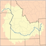
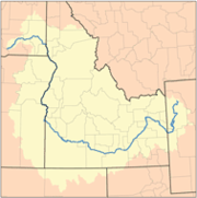 Fruitland is located at 44°0′58"N 116°55′17"W (44.016035, -116.921450), within the Snake River
watershed
.
According to the United States Census Bureau
, the city has a total area of 1.5 square miles (3.9 km²), all land.
of 2000, there were 3,805 people, 1,378 households, and 1,044 families residing in the city. The population density
was 2,512.2 people per square mile (972.9/km²). There were 1,518 housing units at an average density of 1,002.2 per square mile (388.1/km²). The racial makeup of the city was 87.70% White, 0.89% Asian, 0.60% Native American, 0.05% African American, 0.03% Pacific Islander, 8.02% from other races, and 2.71% from two or more races. Hispanic or Latino of any race were 17.92% of the population.
There were 1,378 households out of which 40.6% had children under the age of 18 living with them, 58.1% were married couples
living together, 13.1% had a female householder with no husband present, and 24.2% were non-families. 21.4% of all households were made up of individuals and 10.6% had someone living alone who wais 65 years of age or older. The average household size was 2.76 and the average family size was 3.20.
In the city the population was spread out with 31.9% under the age of 18, 9.0% from 18 to 24, 27.6% from 25 to 44, 18.6% from 45 to 64, and 12.9% who were 65 years of age or older. The median age was 31 years. For every 100 females there were 93.8 males. For every 100 females age 18 and over, there were 87.3 males.
The median income for a household in the city was $32,469, and the median income for a family was $36,614. Males had a median income of $31,419 versus $22,000 for females. The per capita income
for the city was $14,488. About 8.3% of families and 11.9% of the population were below the poverty line, including 15.6% of those under the age of 18 and 14.0% of those 65 and older.
Payette County, Idaho
Payette County is a county located in the U.S. state of Idaho. The county was established in 1917, and at the 2000 Census the county had a population of 20,578 . The county seat is Payette....
, Idaho
Idaho
Idaho is a state in the Rocky Mountain area of the United States. The state's largest city and capital is Boise. Residents are called "Idahoans". Idaho was admitted to the Union on July 3, 1890, as the 43rd state....
, United States
United States
The United States of America is a federal constitutional republic comprising fifty states and a federal district...
. It lies along U.S. Route 95
U.S. Route 95
U.S. Route 95 is a north–south U.S. highway in the western United States. Unlike many other US highways, it has not seen deletion or replacement on most of its length by an encroaching Interstate highway corridor, due to its mostly rural course...
in the Treasure Valley
Treasure Valley
The Treasure Valley is the area of the Western United States where the Payette, Boise, Weiser, Malheur, Owyhee, and Burnt rivers drain into the Snake River. Treasure Valley includes all the lowland areas from Vale, Oregon on the west to Boise, Idaho on the east. Formerly, the valley had been known...
of southwest Idaho, about 50 miles west of Boise
Boise, Idaho
Boise is the capital and most populous city of the U.S. state of Idaho, as well as the county seat of Ada County. Located on the Boise River, it anchors the Boise City-Nampa metropolitan area and is the largest city between Salt Lake City, Utah and Portland, Oregon.As of the 2010 Census Bureau,...
and near the border with Oregon
Oregon
Oregon is a state in the Pacific Northwest region of the United States. It is located on the Pacific coast, with Washington to the north, California to the south, Nevada on the southeast and Idaho to the east. The Columbia and Snake rivers delineate much of Oregon's northern and eastern...
. Fruitland is named after the apple orchards that surround the community, and its slogan is "The Big Apple of Idaho."
As of the 2000 census
United States Census, 2000
The Twenty-second United States Census, known as Census 2000 and conducted by the Census Bureau, determined the resident population of the United States on April 1, 2000, to be 281,421,906, an increase of 13.2% over the 248,709,873 persons enumerated during the 1990 Census...
, the city had a total population of 3,805. It is part of the Ontario
Ontario, Oregon
Ontario is the largest city in Malheur County, Oregon, United States. It lies along the Snake River at the Idaho border. The population was 10,985 at the 2000 census, with an estimated population of 11,245 in 2006...
, OR
Oregon
Oregon is a state in the Pacific Northwest region of the United States. It is located on the Pacific coast, with Washington to the north, California to the south, Nevada on the southeast and Idaho to the east. The Columbia and Snake rivers delineate much of Oregon's northern and eastern...
–ID Micropolitan Statistical Area
Ontario micropolitan area
The Ontario Micropolitan Statistical Area, as defined by the United States Census Bureau, is an area consisting of two counties – one in southeastern Oregon and one in southwestern Idaho, anchored by the city of Ontario....
.
Geography
Snake River
The Snake is a major river of the greater Pacific Northwest in the United States. At long, it is the largest tributary of the Columbia River, the largest North American river that empties into the Pacific Ocean...
watershed
Drainage basin
A drainage basin is an extent or an area of land where surface water from rain and melting snow or ice converges to a single point, usually the exit of the basin, where the waters join another waterbody, such as a river, lake, reservoir, estuary, wetland, sea, or ocean...
.
According to the United States Census Bureau
United States Census Bureau
The United States Census Bureau is the government agency that is responsible for the United States Census. It also gathers other national demographic and economic data...
, the city has a total area of 1.5 square miles (3.9 km²), all land.
Demographics
As of the censusCensus
A census is the procedure of systematically acquiring and recording information about the members of a given population. It is a regularly occurring and official count of a particular population. The term is used mostly in connection with national population and housing censuses; other common...
of 2000, there were 3,805 people, 1,378 households, and 1,044 families residing in the city. The population density
Population density
Population density is a measurement of population per unit area or unit volume. It is frequently applied to living organisms, and particularly to humans...
was 2,512.2 people per square mile (972.9/km²). There were 1,518 housing units at an average density of 1,002.2 per square mile (388.1/km²). The racial makeup of the city was 87.70% White, 0.89% Asian, 0.60% Native American, 0.05% African American, 0.03% Pacific Islander, 8.02% from other races, and 2.71% from two or more races. Hispanic or Latino of any race were 17.92% of the population.
There were 1,378 households out of which 40.6% had children under the age of 18 living with them, 58.1% were married couples
Marriage
Marriage is a social union or legal contract between people that creates kinship. It is an institution in which interpersonal relationships, usually intimate and sexual, are acknowledged in a variety of ways, depending on the culture or subculture in which it is found...
living together, 13.1% had a female householder with no husband present, and 24.2% were non-families. 21.4% of all households were made up of individuals and 10.6% had someone living alone who wais 65 years of age or older. The average household size was 2.76 and the average family size was 3.20.
In the city the population was spread out with 31.9% under the age of 18, 9.0% from 18 to 24, 27.6% from 25 to 44, 18.6% from 45 to 64, and 12.9% who were 65 years of age or older. The median age was 31 years. For every 100 females there were 93.8 males. For every 100 females age 18 and over, there were 87.3 males.
The median income for a household in the city was $32,469, and the median income for a family was $36,614. Males had a median income of $31,419 versus $22,000 for females. The per capita income
Per capita income
Per capita income or income per person is a measure of mean income within an economic aggregate, such as a country or city. It is calculated by taking a measure of all sources of income in the aggregate and dividing it by the total population...
for the city was $14,488. About 8.3% of families and 11.9% of the population were below the poverty line, including 15.6% of those under the age of 18 and 14.0% of those 65 and older.