
Frome Vale
Encyclopedia
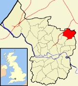
Frome Vale is one of thirty-five city council wards
in Bristol
, England
, and is named after the River Frome
. It contains the suburbs of Broomhill (not to be confused with the Broomhill in the Brislington
ward) and Fishponds, as well as a small part of Frenchay
. The northern and eastern boundaries of the ward border the South Gloucestershire
areas of Downend
and Frenchay.
Notable places in the ward include Snuff Mills
, and the Glenside
and St Matthias
campuses of the University of the West of England
.
, between Stapleton
and Frenchay
. The area is home to the clubhouse of DRG Stapleton Football Club, who play in the Gloucestershire County League
, however the pitch lies across the border in South Gloucestershire
.
 Fishponds is an outer urban area to the east of the English city of Bristol
. It is approximately three miles from the City centre. It has two large Victorian era
park
s; Eastville
Park and Vassell's Park (formerly the Vassell's Family estate). The River Frome
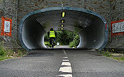
runs through both parks, with the Frome Valley Walkway
running alongside it. A restored mill can be found at Snuff Mills
near the Vassells Park end of the river. It has retained its original waterwheel which can still be seen and heard turning today.
of Bristol that lies partially in the Frome Vale ward, however the vast majority of it, including Frenchay Hospital
is in South Gloucestershire
.
Wards of the United Kingdom
A ward in the United Kingdom is an electoral district at sub-national level represented by one or more councillors. It is the primary unit of British administrative and electoral geography .-England:...
in Bristol
Bristol
Bristol is a city, unitary authority area and ceremonial county in South West England, with an estimated population of 433,100 for the unitary authority in 2009, and a surrounding Larger Urban Zone with an estimated 1,070,000 residents in 2007...
, England
England
England is a country that is part of the United Kingdom. It shares land borders with Scotland to the north and Wales to the west; the Irish Sea is to the north west, the Celtic Sea to the south west, with the North Sea to the east and the English Channel to the south separating it from continental...
, and is named after the River Frome
River Frome, Bristol
The River Frome is a river, approximately long, which rises in Dodington Park, South Gloucestershire, and flows in a south westerly direction through Bristol, joining the former course of the river Avon in Bristol's Floating Harbour. The mean flow at Frenchay is The name Frome is shared with...
. It contains the suburbs of Broomhill (not to be confused with the Broomhill in the Brislington
Brislington
Brislington is an area in the south east of the city of Bristol, England. It is on the edge of Bristol and from Bath. The Brislington Brook runs through the area in the woodlands of Nightingale Valley...
ward) and Fishponds, as well as a small part of Frenchay
Frenchay
Frenchay is a suburb of Bristol, England, to the north east of the city, but located mainly in South Gloucestershire and the Civil Parish of Winterbourne....
. The northern and eastern boundaries of the ward border the South Gloucestershire
South Gloucestershire
South Gloucestershire is a unitary district in the ceremonial county of Gloucestershire, in South West England.-History:The district was created in 1996, when the county of Avon was abolished, by the merger of former area of the districts of Kingswood and Northavon...
areas of Downend
Downend, South Gloucestershire
Downend is a suburb of Bristol in South Gloucestershire, England. It is located to the North East of Bristol and bordered by the Bristol City suburb of Fishponds to its south west and the South Gloucestershire suburbs of Staple Hill to the south, Frenchay to the west and Mangotsfield to the East...
and Frenchay.
Notable places in the ward include Snuff Mills
Snuff Mills
Snuff Mills is a park in the Stapleton area of north Bristol, also known as Whitwood Mill.There are pleasant walks along the steep wooded banks of the River Frome, for example to Oldbury Court...
, and the Glenside
Glenside, Bristol
Glenside campus is the home of the School of Health and Social Care at the University of the West of England , Bristol. It is located on Blackberry Hill in the suburb of Fishponds...
and St Matthias
St Matthias, Bristol
St Matthias is one of the campuses belonging to the University of the West of England. The campus is located in the suburb of Fishponds in Bristol.-History:...
campuses of the University of the West of England
University of the West of England
The University of the West of England is a university based in the English city of Bristol. Its main campus is at Frenchay, about five miles north of the city centre...
.
Broomhill
Broomhill is an area of Bristol that lies to the south of the M32 motorwayM32 motorway
The M32 is a motorway in South Gloucestershire and Bristol, England. It provides a link from Bristol city centre to the M4 and is part of the Bristol Parkway. At about , it is one of Britain's shortest motorways...
, between Stapleton
Stapleton, Bristol
Stapleton is an area in the north-eastern suburbs of the city of Bristol, England. The name is colloquially used today to describe the ribbon village along Bell Hill and Park Road in the Frome Valley. It borders Eastville to the South and Begbrook and Frenchay to the North...
and Frenchay
Frenchay
Frenchay is a suburb of Bristol, England, to the north east of the city, but located mainly in South Gloucestershire and the Civil Parish of Winterbourne....
. The area is home to the clubhouse of DRG Stapleton Football Club, who play in the Gloucestershire County League
Gloucestershire County League
The Gloucestershire County League is a football league in England, founded in 1968. The league is affiliated to the Gloucestershire County FA....
, however the pitch lies across the border in South Gloucestershire
South Gloucestershire
South Gloucestershire is a unitary district in the ceremonial county of Gloucestershire, in South West England.-History:The district was created in 1996, when the county of Avon was abolished, by the merger of former area of the districts of Kingswood and Northavon...
.
Fishponds
Bristol
Bristol is a city, unitary authority area and ceremonial county in South West England, with an estimated population of 433,100 for the unitary authority in 2009, and a surrounding Larger Urban Zone with an estimated 1,070,000 residents in 2007...
. It is approximately three miles from the City centre. It has two large Victorian era
Victorian era
The Victorian era of British history was the period of Queen Victoria's reign from 20 June 1837 until her death on 22 January 1901. It was a long period of peace, prosperity, refined sensibilities and national self-confidence...
park
Park
A park is a protected area, in its natural or semi-natural state, or planted, and set aside for human recreation and enjoyment, or for the protection of wildlife or natural habitats. It may consist of rocks, soil, water, flora and fauna and grass areas. Many parks are legally protected by...
s; Eastville
Eastville, Bristol
Eastville is the name of both a council ward in the city of Bristol in the United Kingdom and a suburb of the city that lies within that ward. The Eastville ward covers the areas of Eastville, Crofts End , Stapleton and part of Fishponds...
Park and Vassell's Park (formerly the Vassell's Family estate). The River Frome
River Frome, Bristol
The River Frome is a river, approximately long, which rises in Dodington Park, South Gloucestershire, and flows in a south westerly direction through Bristol, joining the former course of the river Avon in Bristol's Floating Harbour. The mean flow at Frenchay is The name Frome is shared with...
runs through both parks, with the Frome Valley Walkway
Frome Valley Walkway
The Frome Valley Walkway is an 18 mile footpath which follows the River Frome from the River Avon in the centre of Bristol to the Cotswold Hills in South Gloucestershire...
running alongside it. A restored mill can be found at Snuff Mills
Snuff Mills
Snuff Mills is a park in the Stapleton area of north Bristol, also known as Whitwood Mill.There are pleasant walks along the steep wooded banks of the River Frome, for example to Oldbury Court...
near the Vassells Park end of the river. It has retained its original waterwheel which can still be seen and heard turning today.
Frenchay
Frenchay is a suburbSuburb
The word suburb mostly refers to a residential area, either existing as part of a city or as a separate residential community within commuting distance of a city . Some suburbs have a degree of administrative autonomy, and most have lower population density than inner city neighborhoods...
of Bristol that lies partially in the Frome Vale ward, however the vast majority of it, including Frenchay Hospital
Frenchay Hospital
Frenchay Hospital is a large hospital situated in Frenchay, South Gloucestershire, on the outskirts of Bristol, England, part of the North Bristol NHS Trust....
is in South Gloucestershire
South Gloucestershire
South Gloucestershire is a unitary district in the ceremonial county of Gloucestershire, in South West England.-History:The district was created in 1996, when the county of Avon was abolished, by the merger of former area of the districts of Kingswood and Northavon...
.